Lewis Fork Wilderness

Log in to your account

AroundUs is a community-driven map of interesting places, built by curious explorers like you. It grows with every review, story, and photo you share.
Connect to save your favorite spots, contribute locations, and create personalized routes.
Continue with Google
Continue with Apple
Continue with X
Continue with Facebook
Continue with email
By continuing, you accept our Terms and Conditions and our Privacy Policy
Create an account
Add to collection
Map
Suggest a change
Share

Lewis Fork Wilderness, Protected wilderness area in Mount Rogers National Recreation Area, Virginia.

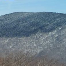
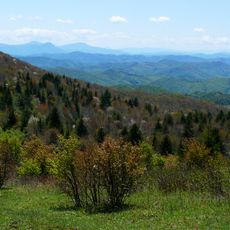
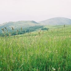
Lewis Fork Wilderness is a protected forest area within the Mount Rogers National Recreation Area that features dense woodland and varying elevations throughout its landscape. The terrain transitions from broadleaf trees in lower sections to evergreen forests where the land rises.

Congress designated this area as protected wilderness in 1984 through the Virginia Wilderness Act, establishing formal protection for its natural resources. This decision reflected growing efforts to preserve wild lands in the Appalachian region.

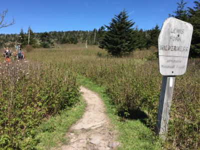
The Appalachian National Scenic Trail crosses through the northeast and southern boundaries of Lewis Fork Wilderness for approximately 5.5 miles of hiking paths.

Visitors should prepare for unmarked trails and travel without motorized equipment to protect the environment. The area requires good planning since there is little infrastructure or trail marking.

The area supports native trout populations in streams like Lewis Fork and provides habitat for species specialized to higher elevations. These waters are part of a complex ecosystem that few visitors actually encounter and understand.

GPS coordinates: 36.65972,-81.54472

Latest update: December 13, 2025 17:06

Photos
Around this place
Mount Rogers
United States of America

Mount Rogers

20 m
Grayson Highlands State Park
United States of America

Grayson Highlands State Park

4.3 km
Hungry Mother State Park
United States of America

Hungry Mother State Park

24.7 km
United States of America

North Carolina–Tennessee–Virginia Corners

14.3 km
Whitetop Mountain
United States of America

Whitetop Mountain

5.9 km
Lincoln Theatre
United States of America

Lincoln Theatre

19.5 km
Preston House
United States of America

Preston House

17.5 km
Abijah Thomas House
United States of America

Abijah Thomas House

12.9 km
Ripshin Farm
United States of America

Ripshin Farm

13 km
United States of America

Mount Rogers Cluster

40 m
United States of America

Whitetop Mountain

5.9 km
United States of America

Whitetop Laurel

14.8 km
Mount Rogers Crest Zone
United States of America

Mount Rogers Crest Zone

3.9 km
Brook Hall
United States of America

Brook Hall

25.7 km
Konnarock Training School
United States of America

Konnarock Training School

6.1 km
Henderson Building
United States of America

Henderson Building

19.5 km
Ashe Metamorphic Suite
United States of America

Ashe Metamorphic Suite

24.5 km
Marion Historic District (Marion, Virginia)
United States of America

Marion Historic District (Marion, Virginia)

19.2 km
A.C. Beatie House
United States of America

A.C. Beatie House

19.9 km
Worth's Chapel
United States of America

Worth's Chapel

22.7 km
H.L. Bonham House
United States of America

H.L. Bonham House

19.4 km
William Waddell House
United States of America

William Waddell House

13.9 km
Marion Male Academy
United States of America

Marion Male Academy

19.1 km
Downtown Chilhowie Historic District
United States of America

Downtown Chilhowie Historic District

19.7 km
John W. Tucker House
United States of America

John W. Tucker House

15.4 km
John M. Pierce House
United States of America

John M. Pierce House

22.6 km
Miller Homestead
United States of America

Miller Homestead

18.7 km
Glade Spring Commercial Historic District
United States of America

Glade Spring Commercial Historic District

25 km
Show the full map
Reviews

Visited this place? Tap the stars to rate it and share your experience / photos with the community! Try now! You can cancel it anytime.

« Lewis Fork Wilderness - Protected wilderness area in Mount Rogers National Recreation Area, Virginia » is provided by Around Us (aroundus.com). Images and texts are derived from Wikimedia project under a Creative Commons license. You are allowed to copy, distribute, and modify copies of this page, under the conditions set by the license, as long as this note is clearly visible.

Discover hidden gems everywhere you go!

From secret cafés to breathtaking viewpoints, skip the crowded tourist spots and find places that match your style. Our app makes it easy with voice search, smart filtering, route optimization, and insider tips from travelers worldwide. Download now for the complete mobile experience.

Around Us App Screenshot

A unique approach to discovering new places

Le Figaro

All the places worth exploring

France Info

A tailor-made excursion in just a few clicks

20 Minutes