Enable Location

We need your location to show you interesting places around you

Discover nearby places

Find interesting locations and hidden gems around you

Precise directions

Get accurate directions and distances to places

Your location is never shared with other users. It's only used when you tap the location button.

Grayson Highlands State Park

Log in to your account

Start exploring — it's free

Trusted by 62,557 travelers worldwide

Continue with Google
Continue with Apple
or

We will send you a code to connect

By continuing, you accept our Terms and Conditions and our Privacy Policy

Check your inbox

We've sent a pincode in your inbox. Please enter the code below.

Grayson Highlands State Park, Mountain state park in Virginia, United States

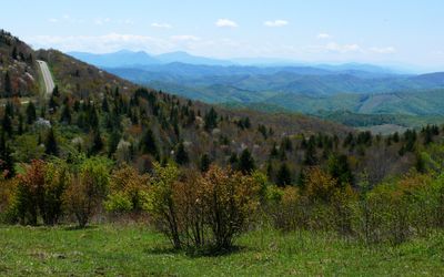
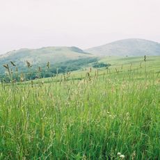
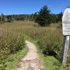
Grayson Highlands State Park is a protected area at 1,100 meters elevation in the mountains of Virginia with several peaks, rock faces and wide-ranging trails. The terrain shifts between open meadows and wooded slopes, threaded with paths that extend across the entire area.

The Virginia administration opened this protected area in 1965 to preserve the mountain landscape near Mount Rogers. Since then, the area has been managed as part of the regional recreation zone and connected to the Appalachian Trail.

The trail system passes through highland meadows where semi-wild ponies roam freely as part of the landscape for decades. These animals move between rocky outcrops and graze on the high plateaus where visitors often observe them at close range.

The trails remain accessible from spring through autumn, while winter weather occasionally brings temporary restrictions. Camping sites and horse trails are available, and visitors should prepare for rapid weather changes at higher elevations.

Around 150 ponies live without fixed fences in the park and graze on the mountain meadows, keeping the open areas intact. These animals have been here for generations and prevent trees from overgrowing the highland plateaus.

The community of curious travelers

AroundUs brings together thousands of curated places, local tips, and hidden gems, enriched daily by 60,000 contributors worldwide.

Start exploring
Location
Inception
1965
Address
Grayson Highland Lane
GPS coordinates
36.62920,-81.51460
Latest update
December 20, 2025 13:09
Around this place
Mount Rogers
United States of America

Mount Rogers

4.3 km
United States of America

North Carolina–Tennessee–Virginia Corners

15.2 km
Whitetop Mountain
United States of America

Whitetop Mountain

8.2 km
Lincoln Theatre
United States of America

Lincoln Theatre

22.7 km
Preston House
United States of America

Preston House

21.7 km
Abijah Thomas House
United States of America

Abijah Thomas House

16.9 km
Ripshin Farm
United States of America

Ripshin Farm

12.3 km
Lewis Fork Wilderness
United States of America

Lewis Fork Wilderness

4.3 km
United States of America

Mount Rogers Cluster

4.3 km
United States of America

Whitetop Mountain

8.4 km
United States of America

Whitetop Laurel

17.3 km
Brookside Farm and Mill
United States of America

Brookside Farm and Mill

25.9 km
United States of America

Mount Rogers Crest Zone

3 km
Ashe County Courthouse
United States of America

Ashe County Courthouse

23.5 km
Konnarock Training School
United States of America

Konnarock Training School

9.8 km
Henderson Building
United States of America

Henderson Building

22.7 km
Ashe Metamorphic Suite
United States of America

Ashe Metamorphic Suite

20.3 km
Marion Historic District (Marion, Virginia)
United States of America

Marion Historic District (Marion, Virginia)

22.5 km
Worth's Chapel
United States of America

Worth's Chapel

20.6 km
Samuel Cox House
United States of America

Samuel Cox House

24.9 km
H.L. Bonham House
United States of America

H.L. Bonham House

23.8 km
William Waddell House
United States of America

William Waddell House

9.6 km
Marion Male Academy
United States of America

Marion Male Academy

22.5 km
William Weaver House
United States of America

William Weaver House

22 km
Bower-Cox House
United States of America

Bower-Cox House

24.5 km
John W. Tucker House
United States of America

John W. Tucker House

12.5 km
John M. Pierce House
United States of America

John M. Pierce House

18.4 km
Miller Homestead
United States of America

Miller Homestead

15.7 km
Show the full map
« Grayson Highlands State Park - Mountain state park in Virginia, United States » is provided by Around Us (aroundus.com). Images and texts are derived from Wikimedia project under a Creative Commons license. You are allowed to copy, distribute, and modify copies of this page, under the conditions set by the license, as long as this note is clearly visible.

Discover hidden gems everywhere you go!

From secret cafés to breathtaking viewpoints, skip the crowded tourist spots and find places that match your style. Our app makes it easy with voice search, smart filtering, route optimization, and insider tips from travelers worldwide. Download now for the complete mobile experience.

Around Us App Screenshot

A unique approach to discovering new places

Le Figaro

All the places worth exploring

France Info

A tailor-made excursion in just a few clicks

20 Minutes

Around Us
Travel Guide & Maps
Download

Send to your phone

QR Code
1

Open the camera app on your mobile.

2

Point at the QR code with your camera. A notification will appear.

3

Tap the notification to open the link.