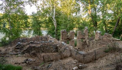
Enable Location

We need your location to show you interesting places around you

Discover nearby places

Find interesting locations and hidden gems around you

Precise directions

Get accurate directions and distances to places

Your location is never shared with other users. It's only used when you tap the location button.

Potomac Mills

Log in to your account

Start exploring — it's free

Trusted by 63,612 travelers worldwide

Continue with Google
Continue with Apple
or

We will send you a code to connect

By continuing, you accept our Terms and Conditions and our Privacy Policy

Check your inbox

We've sent a pincode in your inbox. Please enter the code below.

Discussion Reviews 1 Photos
1.2k Popularity

Potomac Mills

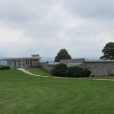
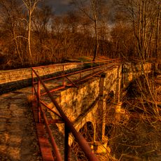
Potomac Mills is a factory in Jefferson County that began in 1826 as a grain mill and later shifted to cement production. The 18-acre site contains ruins of mill buildings, lime kilns, a headrace wall directing water to the mill, office structures, and the remains of a dam that once spanned the river.

Founded in 1826 as a grain mill, the site shifted to cement making in the late 1820s using limestone from nearby quarries. Operations were disrupted by Civil War burning in 1861 and repeated floods in the 1880s, and production ceased around 1900 when Portland cement replaced natural varieties.

The name Potomac Mills reflects its origin as a working mill powered by the river. Today visitors walk through ruins that speak to how local industry shaped daily life and built the region's infrastructure.

The site is accessible on foot and visitors can walk among the ruins and structural remains while reading informational signs explaining the mill's history. The open landscape makes it straightforward to explore the different areas and see the various buildings and dam foundations.

The site witnessed Civil War action when Union troops burned it in 1861 and soldiers crossed the river here during the 1862 Battle of Shepherdstown. The cement produced here was used in major infrastructure projects like dams and bridges that shaped the nation's development.

The community of curious travelers

AroundUs brings together thousands of curated places, local tips, and hidden gems, enriched daily by 60,000 contributors worldwide.

Start exploring
Location
GPS coordinates
39.42830,-77.78000
Latest update
February 9, 2026 07:45
Around this place
Burnside's Bridge
United States of America

Burnside's Bridge

4.8 km
Antietam Creek
United States of America

Antietam Creek

3.2 km
James Rumsey Monument
United States of America

James Rumsey Monument

1.7 km
Shepherdstown Historic District
United States of America

Shepherdstown Historic District

2.4 km
Ram Stadium
United States of America

Ram Stadium

2.3 km
Conrad Shindler House
United States of America

Conrad Shindler House

2.2 km
The American Volunteer
United States of America

The American Volunteer

4.8 km
Van Swearingen-Shepherd House
United States of America

Van Swearingen-Shepherd House

2.5 km
Captain William Lucas and Robert Lucas House
United States of America

Captain William Lucas and Robert Lucas House

3 km
Antietam National Cemetery
United States of America

Antietam National Cemetery

4.8 km
Morgan's Grove
United States of America

Morgan's Grove

3 km
Antietam Iron Furnace Site and Antietam Village
United States of America

Antietam Iron Furnace Site and Antietam Village

3.5 km
Falling Spring-Morgan's Grove
United States of America

Falling Spring-Morgan's Grove

3.1 km
Morgan-Bedinger-Dandridge House
United States of America

Morgan-Bedinger-Dandridge House

2.7 km
Mount Airy
United States of America

Mount Airy

2.5 km
Piper House
United States of America

Piper House

4.5 km
Jacob Highbarger House
United States of America

Jacob Highbarger House

4.1 km
Tolson's Chapel and School
United States of America

Tolson's Chapel and School

4.2 km
Sharpsburg Historic District
United States of America

Sharpsburg Historic District

4.2 km
William Chapline House
United States of America

William Chapline House

4.3 km
Rock Spring
United States of America

Rock Spring

7.5 km
Orndoff-Cross House
United States of America

Orndoff-Cross House

7 km
Good-Reilly House
United States of America

Good-Reilly House

4.3 km
Joseph C. Hays House
United States of America

Joseph C. Hays House

4.2 km
Antietam National Battlefield Visitor Center
United States of America

Antietam National Battlefield Visitor Center

6 km
Norfolk Southern Potomac River Bridge
United States of America

Norfolk Southern Potomac River Bridge

1.6 km
Potomac River Bridge
United States of America

Potomac River Bridge

2.1 km
C&O Canal Antietam Creek Aqueduct
United States of America

C&O Canal Antietam Creek Aqueduct

3.2 km
Show the full map
Reviews
Share your experience

No review yet

Discussions
Start a discussion...

No discussion yet

« Potomac Mills » is provided by Around Us (aroundus.com). Images and texts are derived from Wikimedia project under a Creative Commons license. You are allowed to copy, distribute, and modify copies of this page, under the conditions set by the license, as long as this note is clearly visible.

Discover hidden gems everywhere you go!

From secret cafés to breathtaking viewpoints, skip the crowded tourist spots and find places that match your style. Our app makes it easy with voice search, smart filtering, route optimization, and insider tips from travelers worldwide. Download now for the complete mobile experience.

Around Us App Screenshot

A unique approach to discovering new places

Le Figaro

All the places worth exploring

France Info

A tailor-made excursion in just a few clicks

20 Minutes

Around Us
Travel Guide & Maps
Download

Send to your phone

QR Code
1

Open the camera app on your mobile.

2

Point at the QR code with your camera. A notification will appear.

3

Tap the notification to open the link.