Enable Location

We need your location to show you interesting places around you

Discover nearby places

Find interesting locations and hidden gems around you

Precise directions

Get accurate directions and distances to places

Your location is never shared with other users. It's only used when you tap the location button.

Mount Sterling Commercial Historic District

Log in to your account

Start exploring — it's free

Trusted by 62,170 travelers worldwide

Continue with Google
Continue with Apple
or

We will send you a code to connect

By continuing, you accept our Terms and Conditions and our Privacy Policy

Check your inbox

We've sent a pincode in your inbox. Please enter the code below.

Mount Sterling Commercial Historic District

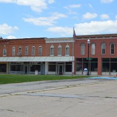
Mount Sterling Commercial Historic District, Commercial Historic District in Mount Sterling, Illinois.

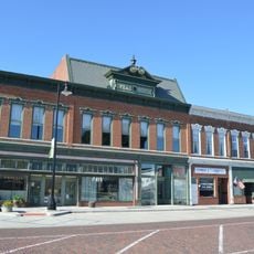
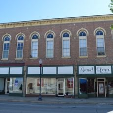
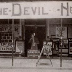
Mount Sterling Commercial Historic District is a downtown area containing historic commercial buildings distributed across several city blocks. The structures display Italianate and Classical Revival architectural styles dating from the late 1800s.

The district developed in the late 1800s as a commercial center and was officially recognized on the National Register of Historic Places in 1987. This action preserved the buildings that defined the economic character of the region during that era.

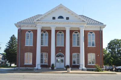
The district displays a mix of commercial and civic identity, where old storefronts stand alongside classical government buildings. You can observe how the architecture reflects the daily life of a 19th-century small town.

The district is located south of the Brown County Courthouse and is easy to access when exploring downtown. You can walk through the area on foot to see the architecture across the different blocks.

The town library operates inside a former hardware store, keeping the original commercial use of the building alive. This shows how old storefronts have been given new purposes while maintaining their character.

The community of curious travelers

AroundUs brings together thousands of curated places, local tips, and hidden gems, enriched daily by 60,000 contributors worldwide.

Start exploring
Location
GPS coordinates
39.98640,-90.76440
Latest update
December 14, 2025 18:44
Around this place
United States of America

Zelph

34.5 km
Naples Mound 8
United States of America

Naples Mound 8

34.1 km
La Grange Lock and Dam
United States of America

La Grange Lock and Dam

20.3 km
Sanganois State Fish and Wildlife Area
United States of America

Sanganois State Fish and Wildlife Area

39.2 km
Valley City Eagle Bridges
United States of America

Valley City Eagle Bridges

34.8 km
United States of America

Pike County Courthouse

42.3 km
Phoenix Opera House Block
United States of America

Phoenix Opera House Block

22.7 km
Beardstown Grand Opera House
United States of America

Beardstown Grand Opera House

28.4 km
F. D. Thomas House
United States of America

F. D. Thomas House

26.4 km
John Shastid House
United States of America

John Shastid House

42.1 km
Pittsfield East School
United States of America

Pittsfield East School

42.1 km
Brown County Courthouse
United States of America

Brown County Courthouse

36 m
Church of Christ
United States of America

Church of Christ

22.8 km
Exchange Bank
United States of America

Exchange Bank

25.6 km
Harvey Lee Ross House
United States of America

Harvey Lee Ross House

44.2 km
Zoe Theatre
United States of America

Zoe Theatre

42.2 km
Ebenezer Methodist Episcopal Chapel and Cemetery
United States of America

Ebenezer Methodist Episcopal Chapel and Cemetery

25.6 km
Schuyler County Courthouse
United States of America

Schuyler County Courthouse

22.7 km
Pittsfield Historic District
United States of America

Pittsfield Historic District

42.1 km
Barry Historic District
United States of America

Barry Historic District

40.2 km
Lucinda Hunter House
United States of America

Lucinda Hunter House

44.4 km
Griggsville Historic District
United States of America

Griggsville Historic District

31.1 km
Joab Mershon House
United States of America

Joab Mershon House

44.3 km
South Fulton Churchhouse
United States of America

South Fulton Churchhouse

43.8 km
Patterson Hamer House
United States of America

Patterson Hamer House

44.4 km
Prairie Mills Windmill
United States of America

Prairie Mills Windmill

25.2 km
Star Theatre
United States of America

Star Theatre

40.4 km
John Roy Site
United States of America

John Roy Site

17.2 km
Show the full map
« Mount Sterling Commercial Historic District - Commercial Historic District in Mount Sterling, Illinois » is provided by Around Us (aroundus.com). Images and texts are derived from Wikimedia project under a Creative Commons license. You are allowed to copy, distribute, and modify copies of this page, under the conditions set by the license, as long as this note is clearly visible.

Discover hidden gems everywhere you go!

From secret cafés to breathtaking viewpoints, skip the crowded tourist spots and find places that match your style. Our app makes it easy with voice search, smart filtering, route optimization, and insider tips from travelers worldwide. Download now for the complete mobile experience.

Around Us App Screenshot

A unique approach to discovering new places

Le Figaro

All the places worth exploring

France Info

A tailor-made excursion in just a few clicks

20 Minutes

Around Us
Travel Guide & Maps
Download

Send to your phone

QR Code
1

Open the camera app on your mobile.

2

Point at the QR code with your camera. A notification will appear.

3

Tap the notification to open the link.