Enable Location

We need your location to show you interesting places around you

Discover nearby places

Find interesting locations and hidden gems around you

Precise directions

Get accurate directions and distances to places

Your location is never shared with other users. It's only used when you tap the location button.

La Grange Lock and Dam

Log in to your account

Start exploring — it's free

Trusted by 62,169 travelers worldwide

Continue with Google
Continue with Apple
or

We will send you a code to connect

By continuing, you accept our Terms and Conditions and our Privacy Policy

Check your inbox

We've sent a pincode in your inbox. Please enter the code below.

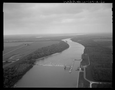
La Grange Lock and Dam, Navigation lock and embankment dam on Illinois River, Brown County, United States.

La Grange Lock and Dam is a navigation lock and embankment dam on the Illinois River in Brown County that moves vessels between different water levels. The structure stretches across the river and includes a lock chamber designed to safely guide boats through.

The U.S. Army Corps of Engineers built this facility between 1936 and 1939 to deepen shipping routes along the Illinois River. This project was part of a broader effort to modernize water transportation capabilities in the region.

The National Register of Historic Places recognized this engineering structure in 2004 for its role in the Illinois Waterway Navigation System.

Visitors can watch the system operate from the surrounding banks as boats pass through and water levels adjust. Good viewing spots exist along the roadside where you can see the locking operations in action.

The facility uses Chanoine wicket gates for water control, a system that differs from other river installations using Tainter gates. This specialized technology enabled more efficient regulation of water flow during vessel transit.

The community of curious travelers

AroundUs brings together thousands of curated places, local tips, and hidden gems, enriched daily by 60,000 contributors worldwide.

Start exploring
Location
Elevation above the sea
134 m
GPS coordinates
39.94080,-90.53390
Latest update
December 13, 2025 11:44
Around this place
United States of America

Zelph

29.6 km
Naples Mound 8
United States of America

Naples Mound 8

29.2 km
United States of America

Fourth principal meridian

10.7 km
Sanganois State Fish and Wildlife Area
United States of America

Sanganois State Fish and Wildlife Area

25.4 km
Valley City Eagle Bridges
United States of America

Valley City Eagle Bridges

29.6 km
Mount Sterling Commercial Historic District
United States of America

Mount Sterling Commercial Historic District

20.3 km
Beecher Hall
United States of America

Beecher Hall

33.8 km
Phoenix Opera House Block
United States of America

Phoenix Opera House Block

20.1 km
Joseph Duncan House
United States of America

Joseph Duncan House

33.6 km
Beardstown Grand Opera House
United States of America

Beardstown Grand Opera House

12.1 km
Ayers Bank Building
United States of America

Ayers Bank Building

34.7 km
Jacksonville, Illinois micropolitan area
United States of America

Jacksonville, Illinois micropolitan area

35 km
Morgan County Courthouse
United States of America

Morgan County Courthouse

34.6 km
Winchester Historic District
United States of America

Winchester Historic District

35.4 km
Brown County Courthouse
United States of America

Brown County Courthouse

20.3 km
Benjamin Henry Grierson House
United States of America

Benjamin Henry Grierson House

35.8 km
Church of Christ
United States of America

Church of Christ

25.2 km
Jacksonville Public Library
United States of America

Jacksonville Public Library

34.8 km
Jacksonville Labor Temple
United States of America

Jacksonville Labor Temple

34.9 km
Scott County Courthouse
United States of America

Scott County Courthouse

35.4 km
Jacksonville Historic District
United States of America

Jacksonville Historic District

33.8 km
Schuyler County Courthouse
United States of America

Schuyler County Courthouse

20.2 km
Griggsville Historic District
United States of America

Griggsville Historic District

30.6 km
South Fulton Churchhouse
United States of America

South Fulton Churchhouse

35.3 km
Jacksonville Downtown Historic District
United States of America

Jacksonville Downtown Historic District

34.7 km
The Paul Findley Congressional Office Museum
United States of America

The Paul Findley Congressional Office Museum

33.9 km
Prairie Land Heritage Museam
United States of America

Prairie Land Heritage Museam

35.2 km
Illinois Theatre
United States of America

Illinois Theatre

34.8 km
Show the full map
« La Grange Lock and Dam - Navigation lock and embankment dam on Illinois River, Brown County, United States » is provided by Around Us (aroundus.com). Images and texts are derived from Wikimedia project under a Creative Commons license. You are allowed to copy, distribute, and modify copies of this page, under the conditions set by the license, as long as this note is clearly visible.

Discover hidden gems everywhere you go!

From secret cafés to breathtaking viewpoints, skip the crowded tourist spots and find places that match your style. Our app makes it easy with voice search, smart filtering, route optimization, and insider tips from travelers worldwide. Download now for the complete mobile experience.

Around Us App Screenshot

A unique approach to discovering new places

Le Figaro

All the places worth exploring

France Info

A tailor-made excursion in just a few clicks

20 Minutes

Around Us
Travel Guide & Maps
Download

Send to your phone

QR Code
1

Open the camera app on your mobile.

2

Point at the QR code with your camera. A notification will appear.

3

Tap the notification to open the link.