Enable Location

We need your location to show you interesting places around you

Discover nearby places

Find interesting locations and hidden gems around you

Precise directions

Get accurate directions and distances to places

Your location is never shared with other users. It's only used when you tap the location button.

Fitzgerald Station and Farmstead

Log in to your account

Start exploring — it's free

Trusted by 63,697 travelers worldwide

Continue with Google
Continue with Apple
or

We will send you a code to connect

By continuing, you accept our Terms and Conditions and our Privacy Policy

Check your inbox

We've sent a pincode in your inbox. Please enter the code below.

Fitzgerald Station and Farmstead
Discussion Reviews 1 Photos
1.2k Popularity

Fitzgerald Station and Farmstead, human settlement in Springdale, Arkansas, United States of America

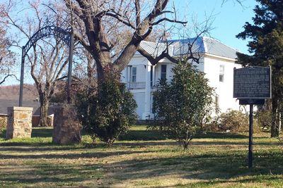
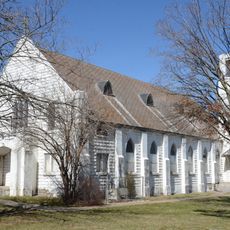
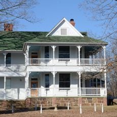
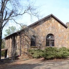
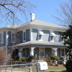
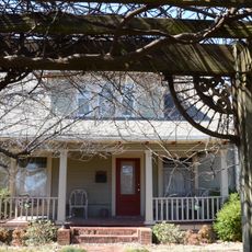
Fitzgerald Station and Farmstead is a historic property near Springdale, Arkansas, with structures dating from the mid-1800s. A stone barn built during the Butterfield Overland Mail era and a brick Greek Revival house from the 1870s remain on the open grounds.

The Fitzgerald family settled in the 1830s and operated an inn and tavern for travelers on the road between Springfield and Fort Smith. From 1858 to 1861, the site served as a stop on the Butterfield Overland Mail stagecoach route connecting Missouri to California.

The name Old Wire Road reflects telegraph lines that later replaced the stagecoach era. Visitors can see how this location marks the shift in how people traveled and stayed connected across the region.

The site is accessible from Dodd Avenue with parking at the Fitzgerald Mountain Trailhead nearby. While historic structures are visible from outside, they are not open to visitors, but the open grounds allow for walking and quiet reflection on the landscape.

In 1837 and 1838, John Fitzgerald purchased supplies for Cherokee people traveling on forced removal westward. Excavations have uncovered pottery fragments and other artifacts from the tavern era, yet the original buildings from that period remain buried.

The community of curious travelers

AroundUs brings together thousands of curated places, local tips, and hidden gems, enriched daily by 60,000 contributors worldwide.

Start exploring
Location
GPS coordinates
36.20530,-94.11360
Latest update
February 9, 2026 07:45
Around this place
Monte Ne
United States of America

Monte Ne

10 km
The Blessings golf course
United States of America

The Blessings golf course

11.3 km
First Baptist Church of Springdale
United States of America

First Baptist Church of Springdale

5.5 km
Botanical Garden of the Ozarks
United States of America

Botanical Garden of the Ozarks

7.6 km
Shiloh Museum of Ozark History
United States of America

Shiloh Museum of Ozark History

2.6 km
Lillard-Sprague House
United States of America

Lillard-Sprague House

11.6 km
Strengthen the Arm of Liberty Monument
United States of America

Strengthen the Arm of Liberty Monument

11.4 km
Old Springdale High School
United States of America

Old Springdale High School

2.9 km
St. Joseph Catholic Church
United States of America

St. Joseph Catholic Church

11.3 km
Skillern House
United States of America

Skillern House

11.6 km
George Park Splash Pad
United States of America

George Park Splash Pad

6.8 km
Johnson House and Mill
United States of America

Johnson House and Mill

9.5 km
Shiloh Church
United States of America

Shiloh Church

2.5 km
Hemingway House and Barn
United States of America

Hemingway House and Barn

10.6 km
Mt. Hebron M.E. Church South and Cemetery
United States of America

Mt. Hebron M.E. Church South and Cemetery

10.7 km
Beasley Homestead
United States of America

Beasley Homestead

2.6 km
Son's Chapel
United States of America

Son's Chapel

11.9 km
Raney House
United States of America

Raney House

12.7 km
Tontitown School Building
United States of America

Tontitown School Building

11.2 km
Beely-Johnson American Legion Post 139
United States of America

Beely-Johnson American Legion Post 139

2.6 km
Fishback School
United States of America

Fishback School

4.3 km
Campbell House
United States of America

Campbell House

13.6 km
McCleod House
United States of America

McCleod House

8.3 km
Troy Gordon House
United States of America

Troy Gordon House

13.3 km
House at 712 N. Mill Street
United States of America

House at 712 N. Mill Street

2.1 km
Vinson House
United States of America

Vinson House

13.3 km
Merrill House
United States of America

Merrill House

13.7 km
Pinkston-Mays Store Building
United States of America

Pinkston-Mays Store Building

5.9 km
Show the full map
Reviews
Share your experience

No review yet

Discussions
Start a discussion...

No discussion yet

« Fitzgerald Station and Farmstead - human settlement in Springdale, Arkansas, United States of America » is provided by Around Us (aroundus.com). Images and texts are derived from Wikimedia project under a Creative Commons license. You are allowed to copy, distribute, and modify copies of this page, under the conditions set by the license, as long as this note is clearly visible.

Discover hidden gems everywhere you go!

From secret cafés to breathtaking viewpoints, skip the crowded tourist spots and find places that match your style. Our app makes it easy with voice search, smart filtering, route optimization, and insider tips from travelers worldwide. Download now for the complete mobile experience.

Around Us App Screenshot

A unique approach to discovering new places

Le Figaro

All the places worth exploring

France Info

A tailor-made excursion in just a few clicks

20 Minutes

Around Us
Travel Guide & Maps
Download

Send to your phone

QR Code
1

Open the camera app on your mobile.

2

Point at the QR code with your camera. A notification will appear.

3

Tap the notification to open the link.