Chest opened
+${chestReward.xp} XP
Explorer
NOUVEAU ×${chestReward.collectible.quantity}
tapez pour fermer
Chest locked

Open chests in the app

Around Us is built for your phone — chests unlock when you walk, explore and capture nearby places.

Enable Location

We need your location to show you interesting places around you

Discover nearby places

Find interesting locations and hidden gems around you

Precise directions

Get accurate directions and distances to places

Your location is never shared with other users. It's only used when you tap the location button.

Log in to your account

Start exploring — it's free

Trusted by 72,888 travelers worldwide

Continue with Google
Continue with Apple
or

We will send you a code to connect

By continuing, you accept our Terms and Conditions and our Privacy Policy

Check your inbox

We've sent a pincode in your inbox. Please enter the code below.

Bluestem Lake
Discussion Reviews Photo
2k Popularity

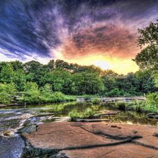
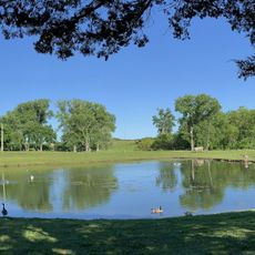
Bluestem Lake, Water reservoir in Osage County, Oklahoma, US

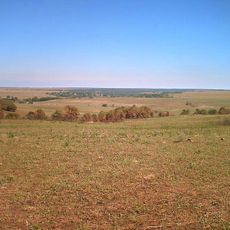
Bluestem Lake is a water reservoir located where Middle Bird Creek and South Bird Creek meet in Osage County. The body of water covers a substantial area with an extended shoreline that accommodates various recreational activities.

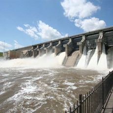
The lake was created in 1958 to manage flood control and provide water supplies for the nearby city of Pawhuska. This project reflected broader efforts to manage water resources across the region.

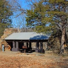
The lake and surrounding area provide opportunities for fishing, boating, and outdoor activities that connect local residents with nature.

The Oklahoma Department of Wildlife Conservation maintains artificial habitats in the lake to support populations of crappie, sunfish, and bass. Visitors can explore these fish species through fishing and boating activities.

Studies revealed that the lake had lost water depth despite maintaining a stable surface size. This shows how reservoirs accumulate sediment and change over time.

The community of curious travelers

AroundUs brings together thousands of curated places, local tips, and hidden gems, enriched daily by 60,000 contributors worldwide.

Start exploring
Location
GPS coordinates
36.70547,-96.41918
Latest update
December 14, 2025 11:26
Around this place
Price Tower
United States of America

Price Tower

39.8 km
Tallgrass Prairie Preserve
United States of America

Tallgrass Prairie Preserve

15.2 km
Woolaroc
United States of America

Woolaroc

28.1 km
Kaw Lake
United States of America

Kaw Lake

37.7 km
Fred and Adeline Drummond House
United States of America

Fred and Adeline Drummond House

32.1 km
Osage Hills State Park
United States of America

Osage Hills State Park

21.7 km
United States of America

Hulah Lake

38.8 km
LaQuinta
United States of America

LaQuinta

41.1 km
Mullendore Mansion
United States of America

Mullendore Mansion

43.3 km
Pawnee Agency and Boarding School Historic District
United States of America

Pawnee Agency and Boarding School Historic District

52.9 km
Bank of Bigheart
United States of America

Bank of Bigheart

28 km
Bank of Hominy
United States of America

Bank of Hominy

32.4 km
Old Washington County Courthouse
United States of America

Old Washington County Courthouse

40.3 km
Pawnee Municipal Swimming Pool and Bathhouse
United States of America

Pawnee Municipal Swimming Pool and Bathhouse

52 km
Pawnee County Courthouse
United States of America

Pawnee County Courthouse

53.3 km
Hominy School
United States of America

Hominy School

32.6 km
Hominy Armory
United States of America

Hominy Armory

32.2 km
Pawnee Armory
United States of America

Pawnee Armory

53.4 km
Hominy Osage Round House
United States of America

Hominy Osage Round House

32.9 km
United States of America

Blackburn Methodist Church

40.3 km
Pawnee Indian Agency
United States of America

Pawnee Indian Agency

52.7 km
City Hall
United States of America

City Hall

8.4 km
Niotaze Methodist Episcopal Church
United States of America

Niotaze Methodist Episcopal Church

54.2 km
Cedar Creek Bridge
United States of America

Cedar Creek Bridge

36.8 km
Osage Casino Hotel - Skiatook
United States of America

Osage Casino Hotel - Skiatook

49.7 km
Drummond House
United States of America

Drummond House

32.1 km
Lake Ponca Duck Pond Historic District
United States of America

Lake Ponca Duck Pond Historic District

54.4 km
Osage Hills State Park Picnic Pavilion
United States of America

Osage Hills State Park Picnic Pavilion

21.4 km
Show the full map
Reviews
Share your experience

No review yet

Discussions
Start a discussion...

No discussion yet

« Bluestem Lake - Water reservoir in Osage County, Oklahoma, US » is provided by Around Us (aroundus.com). Images and texts are derived from Wikimedia project under a Creative Commons license. You are allowed to copy, distribute, and modify copies of this page, under the conditions set by the license, as long as this note is clearly visible.

Discover hidden gems everywhere you go!

From secret cafés to breathtaking viewpoints, skip the crowded tourist spots and find places that match your style. Our app makes it easy with voice search, smart filtering, route optimization, and insider tips from travelers worldwide. Download now for the complete mobile experience.

Around Us App Screenshot

A unique approach to discovering new places

Le Figaro

All the places worth exploring

France Info

A tailor-made excursion in just a few clicks

20 Minutes

Around Us
Travel Guide & Maps
Download

Send to your phone

QR Code
1

Open the camera app on your mobile.

2

Point at the QR code with your camera. A notification will appear.

3

Tap the notification to open the link.