Enable Location

We need your location to show you interesting places around you

Discover nearby places

Find interesting locations and hidden gems around you

Precise directions

Get accurate directions and distances to places

Your location is never shared with other users. It's only used when you tap the location button.

State Game Lands Number 256

Log in to your account

Start exploring — it's free

Trusted by 62,413 travelers worldwide

Continue with Google
Continue with Apple
or

We will send you a code to connect

By continuing, you accept our Terms and Conditions and our Privacy Policy

Check your inbox

We've sent a pincode in your inbox. Please enter the code below.

State Game Lands Number 256

State Game Lands Number 256, park in the United States of America

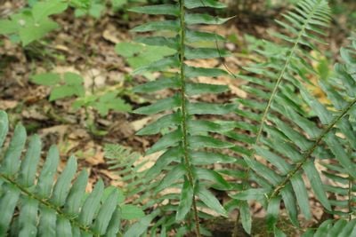
State Game Lands Number 256 is a forest area spanning over a thousand acres in Perry County with gently rolling terrain and numerous small streams winding through the woods. The landscape features dense tree cover, ferns, bushes, and mossy undergrowth, creating diverse habitat layers that support wildlife throughout the seasons.

This land has been used for hunting and food gathering for many decades, shaped by indigenous peoples, settlers, and modern communities. The state acquired and manages it as part of a conservation program that balances wildlife protection with public hunting traditions and outdoor recreation.

The land is woven into the hunting traditions and outdoor practices of the local community, who regard it as an important place for recreation and connecting with nature. Visitors notice how the area supports early morning outdoor routines and seasonal rhythms tied to game seasons and wildlife watching.

Wear sturdy footwear and bring water and appropriate gear for outdoor activities, using marked entrances and parking areas to access the land. During hunting season, wear bright orange clothing for safety, and follow posted rules about permitted activities, vehicle use, and restricted areas to protect wildlife.

During certain seasons, snowmobiles are permitted on designated trails, offering a different way to explore the snowy landscape and experience the quiet of winter in a way that changes how visitors perceive the land. This seasonal variation shows how the terrain transforms and provides distinct experiences depending on when you visit.

The community of curious travelers

AroundUs brings together thousands of curated places, local tips, and hidden gems, enriched daily by 60,000 contributors worldwide.

Start exploring
Location
GPS coordinates
40.40000,-77.13306
Latest update
February 9, 2026 07:40
Around this place
Carlisle Indian Industrial School
United States of America

Carlisle Indian Industrial School

21.6 km
Rockville Bridge
United States of America

Rockville Bridge

20.3 km
U.S. Army Heritage and Education Center
United States of America

U.S. Army Heritage and Education Center

21.6 km
Little Buffalo State Park
United States of America

Little Buffalo State Park

6.7 km
Old West, Dickinson College
United States of America

Old West, Dickinson College

22.6 km
Archibald McAllister House
United States of America

Archibald McAllister House

19.9 km
Clemson Island Prehistoric District
United States of America

Clemson Island Prehistoric District

17.5 km
Dellville Covered Bridge
United States of America

Dellville Covered Bridge

4.3 km
Johannes Eberly House
United States of America

Johannes Eberly House

22.1 km
Carlisle Historic District
United States of America

Carlisle Historic District

22.4 km
Newport Historic District
United States of America

Newport Historic District

8.6 km
Perry County Courthouse
United States of America

Perry County Courthouse

5.1 km
Carlisle Armory
United States of America

Carlisle Armory

20.4 km
Rice Covered Bridge
United States of America

Rice Covered Bridge

16.6 km
Saville Covered Bridge
United States of America

Saville Covered Bridge

22.7 km
Kochendefer Covered Bridge
United States of America

Kochendefer Covered Bridge

21.7 km
Red Covered Bridge
United States of America

Red Covered Bridge

21.2 km
Waggoner Covered Bridge
United States of America

Waggoner Covered Bridge

20.8 km
Fort Hunter Historic District
United States of America

Fort Hunter Historic District

20.1 km
Bridge in Newport Borough
United States of America

Bridge in Newport Borough

8.3 km
John Ayres House
United States of America

John Ayres House

15.7 km
George Trimble House
United States of America

George Trimble House

16.2 km
Fleisher Covered Bridge
United States of America

Fleisher Covered Bridge

10.2 km
Dunbar-Creigh House
United States of America

Dunbar-Creigh House

16.1 km
Bridge in Reed Township
United States of America

Bridge in Reed Township

12.7 km
Little Buffalo Historic District
United States of America

Little Buffalo Historic District

6.9 km
Marysville Bridge
United States of America

Marysville Bridge

17.9 km
Halifax, Pennsylvania
United States of America

Halifax, Pennsylvania

18.7 km
Show the full map
« State Game Lands Number 256 - park in the United States of America » is provided by Around Us (aroundus.com). Images and texts are derived from Wikimedia project under a Creative Commons license. You are allowed to copy, distribute, and modify copies of this page, under the conditions set by the license, as long as this note is clearly visible.

Discover hidden gems everywhere you go!

From secret cafés to breathtaking viewpoints, skip the crowded tourist spots and find places that match your style. Our app makes it easy with voice search, smart filtering, route optimization, and insider tips from travelers worldwide. Download now for the complete mobile experience.

Around Us App Screenshot

A unique approach to discovering new places

Le Figaro

All the places worth exploring

France Info

A tailor-made excursion in just a few clicks

20 Minutes

Around Us
Travel Guide & Maps
Download

Send to your phone

QR Code
1

Open the camera app on your mobile.

2

Point at the QR code with your camera. A notification will appear.

3

Tap the notification to open the link.