Enable Location

We need your location to show you interesting places around you

Discover nearby places

Find interesting locations and hidden gems around you

Precise directions

Get accurate directions and distances to places

Your location is never shared with other users. It's only used when you tap the location button.

Dellville Covered Bridge

Log in to your account

Start exploring — it's free

Trusted by 63,307 travelers worldwide

Continue with Google
Continue with Apple
or

We will send you a code to connect

By continuing, you accept our Terms and Conditions and our Privacy Policy

Check your inbox

We've sent a pincode in your inbox. Please enter the code below.

Discussion Reviews 1 Photos
1.2k Popularity

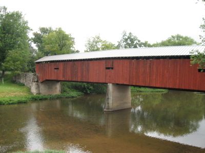
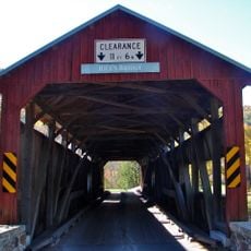
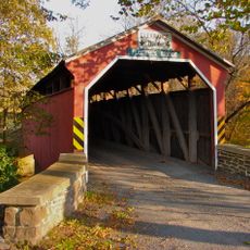
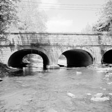
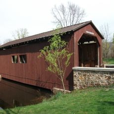
Dellville Covered Bridge, Covered bridge in Wheatfield Township, Pennsylvania.

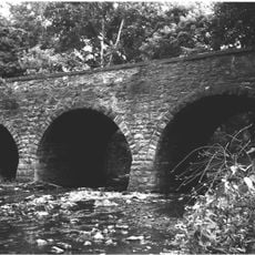
The Dellville Covered Bridge is a three-span structure crossing Shermans Creek with a burr truss design built primarily from wood. The construction incorporates steel reinforcement to support the load across the water below.

The bridge was built in 1889 by Andrew Clouser and listed on the National Register of Historic Places in 1980. A fire destroyed it in 2014, but it was faithfully reconstructed to match the original design.

The bridge reflects how rural communities once relied on wooden structures to connect settlements across waterways. Such crossings were everyday landmarks that shaped how people moved through the landscape.

The bridge is open to foot traffic and vehicles, though caution is needed in this rural setting. Visit during daylight hours for the best visibility of the wooden construction and structural details.

After the fire in 2014, the bridge was completely rebuilt within a few years and reopened the crossing. The reconstruction demonstrates how modern techniques can faithfully preserve a historical wooden structure.

The community of curious travelers

AroundUs brings together thousands of curated places, local tips, and hidden gems, enriched daily by 60,000 contributors worldwide.

Start exploring
Location
GPS coordinates
40.36361,-77.11667
Latest update
December 14, 2025 18:04
Around this place
Rockville Bridge
United States of America

Rockville Bridge

17.8 km
U.S. Army Heritage and Education Center
United States of America

U.S. Army Heritage and Education Center

17.8 km
Little Buffalo State Park
United States of America

Little Buffalo State Park

10.9 km
Old West, Dickinson College
United States of America

Old West, Dickinson College

19.1 km
Hessian Powder Magazine
United States of America

Hessian Powder Magazine

19.2 km
Archibald McAllister House
United States of America

Archibald McAllister House

17.7 km
Irving Female College
United States of America

Irving Female College

19.4 km
Clemson Island Prehistoric District
United States of America

Clemson Island Prehistoric District

18.4 km
Adam Orris House
United States of America

Adam Orris House

19 km
Johannes Eberly House
United States of America

Johannes Eberly House

18.1 km
Carlisle Historic District
United States of America

Carlisle Historic District

18.9 km
State Game Lands Number 256
United States of America

State Game Lands Number 256

4.3 km
Newport Historic District
United States of America

Newport Historic District

12.8 km
Perry County Courthouse
United States of America

Perry County Courthouse

8.7 km
Carlisle Armory
United States of America

Carlisle Armory

16.8 km
Rice Covered Bridge
United States of America

Rice Covered Bridge

16.6 km
Mechanicsburg Commercial Historic District
United States of America

Mechanicsburg Commercial Historic District

19.1 km
Fort Hunter Historic District
United States of America

Fort Hunter Historic District

17.8 km
Bridge in Newport Borough
United States of America

Bridge in Newport Borough

12.4 km
John Ayres House
United States of America

John Ayres House

14.8 km
George Trimble House
United States of America

George Trimble House

11.9 km
Fleisher Covered Bridge
United States of America

Fleisher Covered Bridge

14.5 km
Dunbar-Creigh House
United States of America

Dunbar-Creigh House

16.3 km
Bridge in Reed Township
United States of America

Bridge in Reed Township

12.4 km
Little Buffalo Historic District
United States of America

Little Buffalo Historic District

11.2 km
Marysville Bridge
United States of America

Marysville Bridge

15.9 km
Halifax, Pennsylvania
United States of America

Halifax, Pennsylvania

19.6 km
Everhart Bridge
United States of America

Everhart Bridge

17.9 km
Show the full map
Reviews
Share your experience

No review yet

Discussions
Start a discussion...

No discussion yet

« Dellville Covered Bridge - Covered bridge in Wheatfield Township, Pennsylvania » is provided by Around Us (aroundus.com). Images and texts are derived from Wikimedia project under a Creative Commons license. You are allowed to copy, distribute, and modify copies of this page, under the conditions set by the license, as long as this note is clearly visible.

Discover hidden gems everywhere you go!

From secret cafés to breathtaking viewpoints, skip the crowded tourist spots and find places that match your style. Our app makes it easy with voice search, smart filtering, route optimization, and insider tips from travelers worldwide. Download now for the complete mobile experience.

Around Us App Screenshot

A unique approach to discovering new places

Le Figaro

All the places worth exploring

France Info

A tailor-made excursion in just a few clicks

20 Minutes

Around Us
Travel Guide & Maps
Download

Send to your phone

QR Code
1

Open the camera app on your mobile.

2

Point at the QR code with your camera. A notification will appear.

3

Tap the notification to open the link.