Enable Location

We need your location to show you interesting places around you

Discover nearby places

Find interesting locations and hidden gems around you

Precise directions

Get accurate directions and distances to places

Your location is never shared with other users. It's only used when you tap the location button.

Indian Brook Reservoir

Log in to your account

Start exploring — it's free

Trusted by 62,460 travelers worldwide

Continue with Google
Continue with Apple
or

We will send you a code to connect

By continuing, you accept our Terms and Conditions and our Privacy Policy

Check your inbox

We've sent a pincode in your inbox. Please enter the code below.

Indian Brook Reservoir

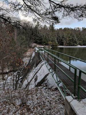
Indian Brook Reservoir, body of water

Indian Brook Reservoir is a 60-acre water body in Essex surrounded by a circular trail used for walking, horseback riding, and biking. The area spans 740 acres of parkland with picnic areas, multiple trails of varying difficulty, and ample parking.

The location was shaped by early settlers of the region, whose heritage is preserved in the waterway's name. In recent years, management rules and visitor passes have been introduced to balance recreation with land protection.

The name Indian Brook reflects the area's earlier inhabitants and the waterway that flows through the land. Today, local people use this place as a gathering spot, particularly on weekends, when families and dog owners fill the trails around the water.

Access is via Route 15 then Old Stage Road and Indian Brook Road leading to parking areas. Multiple lots exist, including one near the boat launch and another for hikers and cyclists, making orientation straightforward.

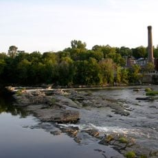
A viewpoint accessible from the upper parking lot offers views of Malletts Bay and requires scrambling over rocks. Many visitors miss this elevated route despite it offering one of the best panoramas in the park.

The community of curious travelers

AroundUs brings together thousands of curated places, local tips, and hidden gems, enriched daily by 60,000 contributors worldwide.

Start exploring
GPS coordinates
44.53500,-73.09861
Latest update
February 9, 2026 07:45
Around this place
Ira Allen Chapel
United States of America

Ira Allen Chapel

10.1 km
Billings Library
United States of America

Billings Library

10.1 km
Old Ohavi Zedek Synagogue
United States of America

Old Ohavi Zedek Synagogue

10.1 km
Grasse Mount
United States of America

Grasse Mount

10.6 km
Winooski Falls Mill District
United States of America

Winooski Falls Mill District

8.7 km
Converse Hall
United States of America

Converse Hall

9.9 km
Ohavi Zedek
United States of America

Ohavi Zedek

9.8 km
Morrill Hall
United States of America

Morrill Hall

10.3 km
Dudley H. Davis Center
United States of America

Dudley H. Davis Center

10.2 km
Galusha House
United States of America

Galusha House

8.8 km
University Green Historic District
United States of America

University Green Historic District

10.3 km
Old Red Mill and Mill House
United States of America

Old Red Mill and Mill House

8.5 km
Methodist Episcopal Church of Winooski
United States of America

Methodist Episcopal Church of Winooski

8.6 km
WCAT Radio Tower
United States of America

WCAT Radio Tower

10.1 km
Downtown Essex Junction Commercial Historic District
United States of America

Downtown Essex Junction Commercial Historic District

4.7 km
Lucy Ruggles House
United States of America

Lucy Ruggles House

10.6 km
Old Stone House
United States of America

Old Stone House

8.3 km
Pearl Street Historic District
United States of America

Pearl Street Historic District

10.6 km
Normand House
United States of America

Normand House

10.3 km
Johnson House
United States of America

Johnson House

10.2 km
Winooski Block
United States of America

Winooski Block

8.5 km
Main Street-College Street Historic District
United States of America

Main Street-College Street Historic District

10.6 km
Porter Screen Company
United States of America

Porter Screen Company

8 km
Charles R. Palmer House
United States of America

Charles R. Palmer House

10.1 km
Jericho Village Historic District
United States of America

Jericho Village Historic District

8.7 km
Mintzer House
United States of America

Mintzer House

10.3 km
LeFerriere House
United States of America

LeFerriere House

10.3 km
United States of America

Roswell Butler House

3.1 km
Show the full map
« Indian Brook Reservoir - body of water » is provided by Around Us (aroundus.com). Images and texts are derived from Wikimedia project under a Creative Commons license. You are allowed to copy, distribute, and modify copies of this page, under the conditions set by the license, as long as this note is clearly visible.

Discover hidden gems everywhere you go!

From secret cafés to breathtaking viewpoints, skip the crowded tourist spots and find places that match your style. Our app makes it easy with voice search, smart filtering, route optimization, and insider tips from travelers worldwide. Download now for the complete mobile experience.

Around Us App Screenshot

A unique approach to discovering new places

Le Figaro

All the places worth exploring

France Info

A tailor-made excursion in just a few clicks

20 Minutes

Around Us
Travel Guide & Maps
Download

Send to your phone

QR Code
1

Open the camera app on your mobile.

2

Point at the QR code with your camera. A notification will appear.

3

Tap the notification to open the link.