Enable Location

We need your location to show you interesting places around you

Discover nearby places

Find interesting locations and hidden gems around you

Precise directions

Get accurate directions and distances to places

Your location is never shared with other users. It's only used when you tap the location button.

Old Red Mill and Mill House

Log in to your account

Start exploring — it's free

Trusted by 61,897 travelers worldwide

Continue with Google
Continue with Apple
or

We will send you a code to connect

By continuing, you accept our Terms and Conditions and our Privacy Policy

Check your inbox

We've sent a pincode in your inbox. Please enter the code below.

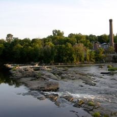
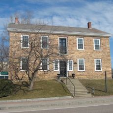
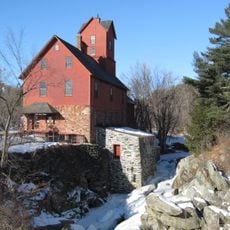
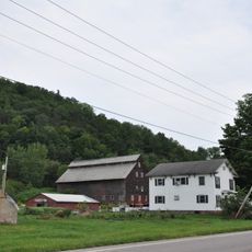
Old Red Mill and Mill House, Historic mill and residence in Jericho, Vermont.

The Old Red Mill is a historic building complex in Jericho with stone walls on the ground floor and wood framing on upper levels covered in red-painted metal siding. The site includes a square tower at the northeast corner and a wheelhouse with a low roof that extends directly into the Browns River.

The building was constructed in 1856 as a working mill and later upgraded in 1885 with grain rollers under L.B. Howe's management. The operation continued producing until it ceased functioning in 1946.

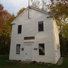
The Jericho Historical Society maintains this site as a museum where visitors can see exhibits about milling work and how the community developed around such industries. Walking through the rooms gives a sense of how the mill shaped daily life for people in the area.

The site is located on Red Mill Drive adjacent to Vermont Route 15, making it easy to find and access from the main road. The riverside setting offers a pleasant environment for walking around the complex and viewing the buildings from different angles.

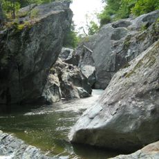
The wheelhouse extends directly into the Browns River, an unusual feature that allowed the machinery to be powered directly by the flowing water. This close integration with the river demonstrates how mills depended on immediate access to water power for their operations.

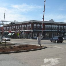
The community of curious travelers

AroundUs brings together thousands of curated places, local tips, and hidden gems, enriched daily by 60,000 contributors worldwide.

Start exploring
Location
GPS coordinates
44.50472,-73.00000
Latest update
December 14, 2025 18:45
Around this place
Mount Mansfield
United States of America

Mount Mansfield

15.4 km
Old Round Church
United States of America

Old Round Church

11.7 km
Mount Mansfield State Forest
United States of America

Mount Mansfield State Forest

14.5 km
Winooski Falls Mill District
United States of America

Winooski Falls Mill District

15 km
Galusha House
United States of America

Galusha House

306 m
Underhill State Park
United States of America

Underhill State Park

13.6 km
Indian Brook Reservoir
United States of America

Indian Brook Reservoir

8.5 km
St. Thomas Church
United States of America

St. Thomas Church

7.9 km
Wilson Alwyn "Snowflake" Bentley House
United States of America

Wilson Alwyn "Snowflake" Bentley House

8.1 km
Methodist Episcopal Church of Winooski
United States of America

Methodist Episcopal Church of Winooski

15 km
Browns River Covered Bridge
United States of America

Browns River Covered Bridge

12 km
Winooski River Bridge
United States of America

Winooski River Bridge

9.2 km
Downtown Essex Junction Commercial Historic District
United States of America

Downtown Essex Junction Commercial Historic District

8.8 km
Richmond Congregational Church
United States of America

Richmond Congregational Church

11.2 km
Old Stone House
United States of America

Old Stone House

14.7 km
Martin Chittenden House
United States of America

Martin Chittenden House

5.5 km
Winooski Block
United States of America

Winooski Block

14.8 km
Jonesville Academy
United States of America

Jonesville Academy

14.6 km
Porter Screen Company
United States of America

Porter Screen Company

14.5 km
Gray Rocks
United States of America

Gray Rocks

11.7 km
Jericho Center Historic District
United States of America

Jericho Center Historic District

4.4 km
Jericho Village Historic District
United States of America

Jericho Village Historic District

166 m
District No. 5 Schoolhouse
United States of America

District No. 5 Schoolhouse

8.3 km
Martin M. Bates Farmstead
United States of America

Martin M. Bates Farmstead

15.5 km
Williston Village Historic District
United States of America

Williston Village Historic District

9.3 km
M. S. Whitcomb Farm
United States of America

M. S. Whitcomb Farm

12.6 km
United States of America

Roswell Butler House

6.7 km
Huntington Gorge
United States of America

Huntington Gorge

15.5 km
Show the full map
« Old Red Mill and Mill House - Historic mill and residence in Jericho, Vermont » is provided by Around Us (aroundus.com). Images and texts are derived from Wikimedia project under a Creative Commons license. You are allowed to copy, distribute, and modify copies of this page, under the conditions set by the license, as long as this note is clearly visible.

Discover hidden gems everywhere you go!

From secret cafés to breathtaking viewpoints, skip the crowded tourist spots and find places that match your style. Our app makes it easy with voice search, smart filtering, route optimization, and insider tips from travelers worldwide. Download now for the complete mobile experience.

Around Us App Screenshot

A unique approach to discovering new places

Le Figaro

All the places worth exploring

France Info

A tailor-made excursion in just a few clicks

20 Minutes

Around Us
Travel Guide & Maps
Download

Send to your phone

QR Code
1

Open the camera app on your mobile.

2

Point at the QR code with your camera. A notification will appear.

3

Tap the notification to open the link.