Enable Location

We need your location to show you interesting places around you

Discover nearby places

Find interesting locations and hidden gems around you

Precise directions

Get accurate directions and distances to places

Your location is never shared with other users. It's only used when you tap the location button.

Huntington Gorge

Log in to your account

Start exploring — it's free

Trusted by 62,442 travelers worldwide

Continue with Google
Continue with Apple
or

We will send you a code to connect

By continuing, you accept our Terms and Conditions and our Privacy Policy

Check your inbox

We've sent a pincode in your inbox. Please enter the code below.

Huntington Gorge

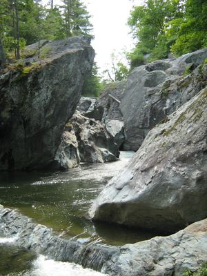
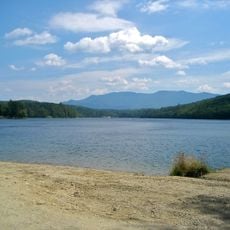
Huntington Gorge, Waterfall and gorge in Richmond, Vermont.

Huntington Gorge is a waterfall and rocky gorge carved by the Huntington River as it flows through narrow channels in the surrounding bedrock. The water drops across multiple levels, creating a series of cascades and rapids that wind through the tight passage.

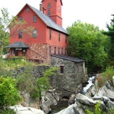
The area saw indigenous peoples traveling through for thousands of years, followed by mill operators who settled along the river in the 1800s. These early industries shaped how people used and viewed this corner of the landscape.

The gorge became part of the Ondawa Girl Scout Camp in the 1950s, marking the beginning of structured rescue operations in this location.

Visitors can reach the site on foot, but slippery rocks and strong currents make conditions challenging. Proper footwear and caution are important, especially after rain when water levels rise.

The gorge features a natural passage carved through bedrock that rises about 80 feet high and extends roughly a mile and a half. This deep rocky corridor is notably narrow and compressed compared to most river valleys nearby.

The community of curious travelers

AroundUs brings together thousands of curated places, local tips, and hidden gems, enriched daily by 60,000 contributors worldwide.

Start exploring
Location
GPS coordinates
44.36731,-72.96893
Latest update
December 6, 2025 19:09
Hidden places in Vermont: granite quarries, covered bridges, historic villages

Vermont hides historic places away from main roads, often forgotten by hurried travelers. Here you find granite quarries still working or long abandoned, small rural schools from the 1800s where children learned together, wooden covered bridges, and waterfalls flowing through thick forests. Trails...

Around this place
Camel's Hump
United States of America

Camel's Hump

8.5 km
Old Round Church
United States of America

Old Round Church

4.3 km
Little River State Park
United States of America

Little River State Park

16.2 km
Galusha House
United States of America

Galusha House

15.3 km
Birds of Vermont Museum
United States of America

Birds of Vermont Museum

3.5 km
St. Thomas Church
United States of America

St. Thomas Church

16.5 km
Old Red Mill and Mill House
United States of America

Old Red Mill and Mill House

15.5 km
Wilson Alwyn "Snowflake" Bentley House
United States of America

Wilson Alwyn "Snowflake" Bentley House

9.7 km
Honey Hollow Camp
United States of America

Honey Hollow Camp

4.4 km
Sequin Covered Bridge
United States of America

Sequin Covered Bridge

16.9 km
Winooski River Bridge
United States of America

Winooski River Bridge

7.3 km
Richmond Congregational Church
United States of America

Richmond Congregational Church

4.6 km
Martin Chittenden House
United States of America

Martin Chittenden House

10.9 km
Cicero Goddard Peck House
United States of America

Cicero Goddard Peck House

11.9 km
Jonesville Academy
United States of America

Jonesville Academy

2.9 km
Huntington Lower Village Church
United States of America

Huntington Lower Village Church

4.8 km
Winooski Street Bridge
United States of America

Winooski Street Bridge

16.6 km
Starksboro Village Meeting House
United States of America

Starksboro Village Meeting House

17.3 km
Gray Rocks
United States of America

Gray Rocks

3.8 km
Hoag Gristmill and Knight House Complex
United States of America

Hoag Gristmill and Knight House Complex

15.9 km
Jericho Center Historic District
United States of America

Jericho Center Historic District

11.5 km
Jericho Village Historic District
United States of America

Jericho Village Historic District

15.4 km
District No. 5 Schoolhouse
United States of America

District No. 5 Schoolhouse

16.8 km
Martin M. Bates Farmstead
United States of America

Martin M. Bates Farmstead

2.2 km
Preston-Lafreniere Farm
United States of America

Preston-Lafreniere Farm

5 km
Williston Village Historic District
United States of America

Williston Village Historic District

11.3 km
Remington-Williamson Farm
United States of America

Remington-Williamson Farm

7.5 km
M. S. Whitcomb Farm
United States of America

M. S. Whitcomb Farm

3.3 km
Show the full map
« Huntington Gorge - Waterfall and gorge in Richmond, Vermont » is provided by Around Us (aroundus.com). Images and texts are derived from Wikimedia project under a Creative Commons license. You are allowed to copy, distribute, and modify copies of this page, under the conditions set by the license, as long as this note is clearly visible.

Discover hidden gems everywhere you go!

From secret cafés to breathtaking viewpoints, skip the crowded tourist spots and find places that match your style. Our app makes it easy with voice search, smart filtering, route optimization, and insider tips from travelers worldwide. Download now for the complete mobile experience.

Around Us App Screenshot

A unique approach to discovering new places

Le Figaro

All the places worth exploring

France Info

A tailor-made excursion in just a few clicks

20 Minutes

Around Us
Travel Guide & Maps
Download

Send to your phone

QR Code
1

Open the camera app on your mobile.

2

Point at the QR code with your camera. A notification will appear.

3

Tap the notification to open the link.