Camel's Hump

Log in to your account

AroundUs is a community-driven map of interesting places, built by curious explorers like you. It grows with every review, story, and photo you share.
Connect to save your favorite spots, contribute locations, and create personalized routes.
Continue with Google
Continue with Apple
Continue with X
Continue with Facebook
Continue with email
By continuing, you accept our Terms and Conditions and our Privacy Policy
Create an account
Add to collection
Map
Suggest a change
Share

Camel's Hump, Mountain summit in Chittenden County, Vermont, United States.

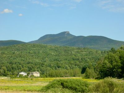
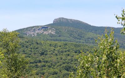
Camel's Hump is Vermont's third-highest mountain, rising to approximately 4,083 feet (1,244 meters) with two distinct peaks separated by a saddle-shaped valley. Glacial activity spanning millions of years sculpted the current formation, leaving a striking two-summit profile.

French explorers in the 1600s named the mountain 'Lion Couchant' based on its visual appearance. By 1798, Ira Allen's map introduced a different name that eventually became the standard designation.

The saddle-shaped profile visible from various viewpoints across the region has shaped how locals and visitors perceive the mountain. People often use it as a landmark to orient themselves within the surrounding landscape.

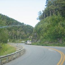
The Burrows Trail and Monroe Trail offer the main direct routes to the summit, each with its own trailhead. Parking areas regularly fill to capacity during summer months, so arriving early in the day is advisable.

A rare alpine tundra ecosystem spans roughly 10 acres near the summit and harbors specialized plants like Bigelow's sedge found nowhere else at this latitude. This high-elevation vegetation is uncommon in the region and resembles ecosystems found much farther north.

Location: Chittenden County

GPS coordinates: 44.31956,-72.88632

Latest update: December 7, 2025 10:06

Photos
Around this place
Buels Gore
United States of America

Buels Gore

13.4 km
Old Round Church
United States of America

Old Round Church

12.6 km
Great Eddy Covered Bridge
United States of America

Great Eddy Covered Bridge

15.4 km
Little River State Park
United States of America

Little River State Park

12.3 km
Birds of Vermont Museum
United States of America

Birds of Vermont Museum

10.2 km
Waterbury Village Historic District
United States of America

Waterbury Village Historic District

10.6 km
Pine Brook Covered Bridge
United States of America

Pine Brook Covered Bridge

14.7 km
Wilson Alwyn "Snowflake" Bentley House
United States of America

Wilson Alwyn "Snowflake" Bentley House

15 km
Honey Hollow Camp
United States of America

Honey Hollow Camp

4.3 km
Knoll Farm
United States of America

Knoll Farm

14.4 km
Green Mountain Seminary
United States of America

Green Mountain Seminary

14.9 km
Winooski River Bridge
United States of America

Winooski River Bridge

15.5 km
Colby Mansion
United States of America

Colby Mansion

11.9 km
Middlesex–Winooski River Bridge
United States of America

Middlesex–Winooski River Bridge

15.2 km
Richmond Congregational Church
United States of America

Richmond Congregational Church

12.8 km
Mad River Valley Rural Historic District
United States of America

Mad River Valley Rural Historic District

13.3 km
Jonesville Academy
United States of America

Jonesville Academy

8.1 km
Huntington Lower Village Church
United States of America

Huntington Lower Village Church

8.2 km
Winooski Street Bridge
United States of America

Winooski Street Bridge

10 km
Gray Rocks
United States of America

Gray Rocks

11.5 km
Mill Village Historic District (Vermont)
United States of America

Mill Village Historic District (Vermont)

11.3 km
Martin M. Bates Farmstead
United States of America

Martin M. Bates Farmstead

10.2 km
Preston-Lafreniere Farm
United States of America

Preston-Lafreniere Farm

6.2 km
Remington-Williamson Farm
United States of America

Remington-Williamson Farm

7 km
M. S. Whitcomb Farm
United States of America

M. S. Whitcomb Farm

10.2 km
Waitsfield Village Historic District
United States of America

Waitsfield Village Historic District

15.2 km
Jones-Pestle Farmstead
United States of America

Jones-Pestle Farmstead

15.7 km
Huntington Gorge
United States of America

Huntington Gorge

8.5 km
Show the full map
Reviews

Visited this place? Tap the stars to rate it and share your experience / photos with the community! Try now! You can cancel it anytime.

« Camel's Hump - Mountain summit in Chittenden County, Vermont, United States » is provided by Around Us (aroundus.com). Images and texts are derived from Wikimedia project under a Creative Commons license. You are allowed to copy, distribute, and modify copies of this page, under the conditions set by the license, as long as this note is clearly visible.

Discover hidden gems everywhere you go!

From secret cafés to breathtaking viewpoints, skip the crowded tourist spots and find places that match your style. Our app makes it easy with voice search, smart filtering, route optimization, and insider tips from travelers worldwide. Download now for the complete mobile experience.

Around Us App Screenshot

A unique approach to discovering new places

Le Figaro

All the places worth exploring

France Info

A tailor-made excursion in just a few clicks

20 Minutes