Mount Mansfield State Forest

Log in to your account

AroundUs is a community-driven map of interesting places, built by curious explorers like you. It grows with every review, story, and photo you share.
Connect to save your favorite spots, contribute locations, and create personalized routes.
Continue with Google
Continue with Apple
Continue with X
Continue with Facebook
Continue with email
By continuing, you accept our Terms and Conditions and our Privacy Policy
Create an account

Mount Mansfield State Forest

Add to collection
Map
Suggest a change
Share

Mount Mansfield State Forest, State forest in Chittenden County, Vermont.

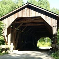
Mount Mansfield State Forest is a large protected forest area in Vermont containing the state's tallest mountain and several state parks within its boundaries. The forest features extensive networks of trails and natural habitats across multiple towns, offering access to varied terrain and outdoor activities throughout the year.

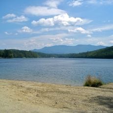
The forest area developed significantly during the 20th century through conservation efforts, including the creation of Waterbury Reservoir in the 1930s. This major infrastructure project was designed to manage flooding and generate electricity for the surrounding communities.

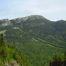
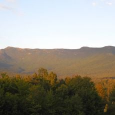
The mountain's profile resembles a human face when viewed from the north, which inspired its name after an early Vermont governor. This distinctive shape has made it an enduring symbol for the region's identity and local pride.

The forest is accessible year-round with different activities suited to each season, including hiking in warmer months and skiing during winter. Multiple trailheads and boat launch areas provide convenient starting points for exploring the forest at various difficulty levels.

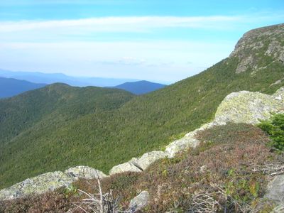
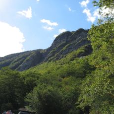
The forest contains Vermont's only alpine tundra habitat located on the mountain's summit ridge, creating an arctic-like landscape in the heart of New England. This rare vegetation type persists from the last ice age and offers visitors a glimpse of ecosystems normally found much further north.

Location: Chittenden County

GPS coordinates: 44.49180,-72.81860

Latest update: December 13, 2025 12:41

Photos
Around this place
Mount Mansfield
United States of America

Mount Mansfield

5.8 km
Long Trail
United States of America

Long Trail

5.4 km
Gold Brook Covered Bridge
United States of America

Gold Brook Covered Bridge

12.4 km
Smugglers' Notch State Park
United States of America

Smugglers' Notch State Park

7.1 km
Vermont Ski and Snowboard Museum
United States of America

Vermont Ski and Snowboard Museum

9.4 km
Little River State Park
United States of America

Little River State Park

12.1 km
Galusha House
United States of America

Galusha House

14.2 km
Underhill State Park
United States of America

Underhill State Park

4.5 km
Grist Mill Covered Bridge
United States of America

Grist Mill Covered Bridge

16.1 km
Red Covered Bridge
United States of America

Red Covered Bridge

11.6 km
St. Thomas Church
United States of America

St. Thomas Church

6.7 km
Old Red Mill and Mill House
United States of America

Old Red Mill and Mill House

14.5 km
Stowe Village Historic District
United States of America

Stowe Village Historic District

10.9 km
Wilson Alwyn "Snowflake" Bentley House
United States of America

Wilson Alwyn "Snowflake" Bentley House

10.2 km
Cambridge Meetinghouse
United States of America

Cambridge Meetinghouse

16.9 km
Green Mountain Seminary
United States of America

Green Mountain Seminary

15 km
Colby Mansion
United States of America

Colby Mansion

16.9 km
The Current
United States of America

The Current

11.1 km
Martin Chittenden House
United States of America

Martin Chittenden House

16.5 km
Waterman Covered Bridge
United States of America

Waterman Covered Bridge

16.9 km
Jonesville Academy
United States of America

Jonesville Academy

15.6 km
Gray Rocks
United States of America

Gray Rocks

16 km
Jericho Center Historic District
United States of America

Jericho Center Historic District

12.4 km
Jericho Village Historic District
United States of America

Jericho Village Historic District

14.3 km
District No. 5 Schoolhouse
United States of America

District No. 5 Schoolhouse

6.4 km
Preston-Lafreniere Farm
United States of America

Preston-Lafreniere Farm

14.9 km
M. S. Whitcomb Farm
United States of America

M. S. Whitcomb Farm

15.3 km
Jeffersonville Historic District
United States of America

Jeffersonville Historic District

17.1 km
Show the full map
Reviews

Visited this place? Tap the stars to rate it and share your experience / photos with the community! Try now! You can cancel it anytime.

« Mount Mansfield State Forest - State forest in Chittenden County, Vermont » is provided by Around Us (aroundus.com). Images and texts are derived from Wikimedia project under a Creative Commons license. You are allowed to copy, distribute, and modify copies of this page, under the conditions set by the license, as long as this note is clearly visible.

Discover hidden gems everywhere you go!

From secret cafés to breathtaking viewpoints, skip the crowded tourist spots and find places that match your style. Our app makes it easy with voice search, smart filtering, route optimization, and insider tips from travelers worldwide. Download now for the complete mobile experience.

Around Us App Screenshot

A unique approach to discovering new places

Le Figaro

All the places worth exploring

France Info

A tailor-made excursion in just a few clicks

20 Minutes