Enable Location

We need your location to show you interesting places around you

Discover nearby places

Find interesting locations and hidden gems around you

Precise directions

Get accurate directions and distances to places

Your location is never shared with other users. It's only used when you tap the location button.

Gold Brook Covered Bridge

Log in to your account

Start exploring — it's free

Trusted by 62,440 travelers worldwide

Continue with Google
Continue with Apple
or

We will send you a code to connect

By continuing, you accept our Terms and Conditions and our Privacy Policy

Check your inbox

We've sent a pincode in your inbox. Please enter the code below.

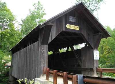
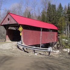
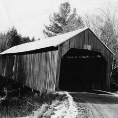
Gold Brook Covered Bridge, Historic covered bridge in Stowe, United States.

Gold Brook Covered Bridge is a wooden crossing over a small stream in Stowe that showcases traditional timber engineering from the 19th century. The structure features wooden beam trusses, vertical wood siding, and a metal gabled roof covering the span.

Construction was completed in 1844 and it remains Vermont's sole surviving example of this wooden truss design still serving as a public road bridge. Its continued use marks it as a rare survivor of 19th century bridge engineering in the state.

The bridge carries the name Emily's Bridge from a local story about a young woman whose life ended tragically near this crossing. Visitors hear this tale woven into how people speak about the place today.

The bridge sits along Covered Bridge Road north of where it meets Gold Brook Road and can be reached on foot from nearby parking areas. Access is open during daylight hours and the site is easily visible from the roadway.

The bridge displays an unusual design feature where the roof structure stops above the wooden wall siding, creating an open gap near the top. This distinctive detail sets it apart from typical covered bridges in the area.

The community of curious travelers

AroundUs brings together thousands of curated places, local tips, and hidden gems, enriched daily by 60,000 contributors worldwide.

Start exploring
Location
GPS coordinates
44.44029,-72.68037
Latest update
December 9, 2025 18:40
Hidden places in Vermont: granite quarries, covered bridges, historic villages

Vermont hides historic places away from main roads, often forgotten by hurried travelers. Here you find granite quarries still working or long abandoned, small rural schools from the 1800s where children learned together, wooden covered bridges, and waterfalls flowing through thick forests. Trails...

Around this place
Mount Mansfield
United States of America

Mount Mansfield

15.7 km
Long Trail
United States of America

Long Trail

14.3 km
Smugglers' Notch State Park
United States of America

Smugglers' Notch State Park

15.6 km
Vermont Ski and Snowboard Museum
United States of America

Vermont Ski and Snowboard Museum

4.3 km
Mount Mansfield State Forest
United States of America

Mount Mansfield State Forest

12.4 km
Elmore State Park
United States of America

Elmore State Park

15.4 km
Little River State Park
United States of America

Little River State Park

8.9 km
Peoples Academy
United States of America

Peoples Academy

15.4 km
Underhill State Park
United States of America

Underhill State Park

15.7 km
Red Covered Bridge
United States of America

Red Covered Bridge

8.7 km
Waterbury Village Historic District
United States of America

Waterbury Village Historic District

13.1 km
St. Thomas Church
United States of America

St. Thomas Church

19 km
Stowe Village Historic District
United States of America

Stowe Village Historic District

2.9 km
Green Mountain Seminary
United States of America

Green Mountain Seminary

7.6 km
Colby Mansion
United States of America

Colby Mansion

11.2 km
Middlesex–Winooski River Bridge
United States of America

Middlesex–Winooski River Bridge

15 km
The Current
United States of America

The Current

2.7 km
Waterman Covered Bridge
United States of America

Waterman Covered Bridge

18.8 km
Lamoille River Route 15-A Bridge
United States of America

Lamoille River Route 15-A Bridge

16.5 km
Worcester Town Hall
United States of America

Worcester Town Hall

12.8 km
Lamoille County Courthouse
United States of America

Lamoille County Courthouse

17.7 km
Morrisville Historic District
United States of America

Morrisville Historic District

15 km
Winooski Street Bridge
United States of America

Winooski Street Bridge

13.1 km
Kents Corner Historic District
United States of America

Kents Corner Historic District

17.4 km
Mill Village Historic District (Vermont)
United States of America

Mill Village Historic District (Vermont)

12.1 km
District No. 5 Schoolhouse
United States of America

District No. 5 Schoolhouse

18.7 km
Worcester Village School
United States of America

Worcester Village School

12.9 km
Lake Elmore Beach
United States of America

Lake Elmore Beach

16.5 km
Show the full map
« Gold Brook Covered Bridge - Historic covered bridge in Stowe, United States » is provided by Around Us (aroundus.com). Images and texts are derived from Wikimedia project under a Creative Commons license. You are allowed to copy, distribute, and modify copies of this page, under the conditions set by the license, as long as this note is clearly visible.

Discover hidden gems everywhere you go!

From secret cafés to breathtaking viewpoints, skip the crowded tourist spots and find places that match your style. Our app makes it easy with voice search, smart filtering, route optimization, and insider tips from travelers worldwide. Download now for the complete mobile experience.

Around Us App Screenshot

A unique approach to discovering new places

Le Figaro

All the places worth exploring

France Info

A tailor-made excursion in just a few clicks

20 Minutes

Around Us
Travel Guide & Maps
Download

Send to your phone

QR Code
1

Open the camera app on your mobile.

2

Point at the QR code with your camera. A notification will appear.

3

Tap the notification to open the link.