Enable Location

We need your location to show you interesting places around you

Discover nearby places

Find interesting locations and hidden gems around you

Precise directions

Get accurate directions and distances to places

Your location is never shared with other users. It's only used when you tap the location button.

Underhill State Park

Log in to your account

Start exploring — it's free

Trusted by 61,892 travelers worldwide

Continue with Google
Continue with Apple
or

We will send you a code to connect

By continuing, you accept our Terms and Conditions and our Privacy Policy

Check your inbox

We've sent a pincode in your inbox. Please enter the code below.

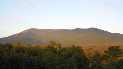
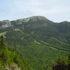
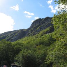
Underhill State Park, State park and historic site in Underhill, Vermont.

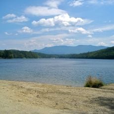
Underhill State Park sits on the western side of Mount Mansfield and covers a large forested area with hiking trails and camping spots. The park has several routes that lead toward the mountain's ridge and others that wind through the terrain at lower elevations.

Workers from the Civilian Conservation Corps built many of the park's trails and facilities in the 1930s. This historical work eventually led to the park's listing on the National Register of Historic Places.

The park allows visitors to experience Vermont's natural landscape firsthand and learn how its forests and mountains shaped the region. Through guided walks and nature programs, guests can observe local plants and wildlife in their natural settings.

The park is open during the warmer months and provides restrooms, water, and picnic areas for visitors. The trails are passable year-round, but the camping sites and main facilities operate only during the peak season.

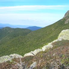
The Sunset Ridge Trail is one of the most direct routes to the summit and offers open views of the mountain landscape during the climb. This path is favored by hikers who want a steep but straightforward ascent without heavy forest cover.

The community of curious travelers

AroundUs brings together thousands of curated places, local tips, and hidden gems, enriched daily by 60,000 contributors worldwide.

Start exploring
Location
GPS coordinates
44.53050,-72.83310
Latest update
December 14, 2025 13:00
Around this place
Mount Mansfield
United States of America

Mount Mansfield

2.1 km
Long Trail
United States of America

Long Trail

3 km
Gold Brook Covered Bridge
United States of America

Gold Brook Covered Bridge

15.7 km
Smugglers' Notch State Park
United States of America

Smugglers' Notch State Park

3.9 km
Vermont Ski and Snowboard Museum
United States of America

Vermont Ski and Snowboard Museum

12.1 km
Mount Mansfield State Forest
United States of America

Mount Mansfield State Forest

4.5 km
Little River State Park
United States of America

Little River State Park

16.5 km
Galusha House
United States of America

Galusha House

13.3 km
Gates Farm Covered Bridge
United States of America

Gates Farm Covered Bridge

13.2 km
Grist Mill Covered Bridge
United States of America

Grist Mill Covered Bridge

11.8 km
Red Covered Bridge
United States of America

Red Covered Bridge

12.4 km
Poland Covered Bridge
United States of America

Poland Covered Bridge

13.5 km
St. Thomas Church
United States of America

St. Thomas Church

6 km
Old Red Mill and Mill House
United States of America

Old Red Mill and Mill House

13.6 km
Stowe Village Historic District
United States of America

Stowe Village Historic District

13.7 km
Wilson Alwyn "Snowflake" Bentley House
United States of America

Wilson Alwyn "Snowflake" Bentley House

11.9 km
Cambridge Meetinghouse
United States of America

Cambridge Meetinghouse

12.6 km
Browns River Covered Bridge
United States of America

Browns River Covered Bridge

16.6 km
The Current
United States of America

The Current

13.9 km
Jeffersonville Bridge
United States of America

Jeffersonville Bridge

13.2 km
Martin Chittenden House
United States of America

Martin Chittenden House

16.9 km
Waterman Covered Bridge
United States of America

Waterman Covered Bridge

14.7 km
Nye Block
United States of America

Nye Block

16.7 km
Jericho Center Historic District
United States of America

Jericho Center Historic District

12.9 km
Bridge 6
United States of America

Bridge 6

16.5 km
Jericho Village Historic District
United States of America

Jericho Village Historic District

13.4 km
District No. 5 Schoolhouse
United States of America

District No. 5 Schoolhouse

5.5 km
Jeffersonville Historic District
United States of America

Jeffersonville Historic District

12.8 km
Show the full map
« Underhill State Park - State park and historic site in Underhill, Vermont » is provided by Around Us (aroundus.com). Images and texts are derived from Wikimedia project under a Creative Commons license. You are allowed to copy, distribute, and modify copies of this page, under the conditions set by the license, as long as this note is clearly visible.

Discover hidden gems everywhere you go!

From secret cafés to breathtaking viewpoints, skip the crowded tourist spots and find places that match your style. Our app makes it easy with voice search, smart filtering, route optimization, and insider tips from travelers worldwide. Download now for the complete mobile experience.

Around Us App Screenshot

A unique approach to discovering new places

Le Figaro

All the places worth exploring

France Info

A tailor-made excursion in just a few clicks

20 Minutes

Around Us
Travel Guide & Maps
Download

Send to your phone

QR Code
1

Open the camera app on your mobile.

2

Point at the QR code with your camera. A notification will appear.

3

Tap the notification to open the link.