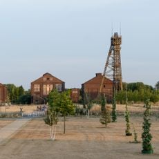
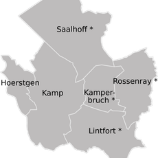
Halde Norddeutschland, Summit and spoil tip in Neukirchen-Vluyn, Germany
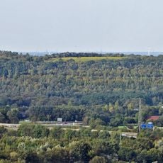
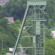
Halde Norddeutschland is a spoil tip in Neukirchen-Vluyn with a height of 102 meters and a steel structure at its peak that resembles an oversized greenhouse. The site covers roughly 90 hectares of former mining land that has been reshaped into a raised landscape.
Between 1952 and 2001, approximately 80 million tons of mining waste accumulated at the site from the neighboring Norddeutschland shaft. This long period of accumulation shaped the landscape and created the hill we see today.
The site hosts festivals that draw electronic music fans to this elevated location for performances by European artists. This use has transformed the place into a gathering spot for music enthusiasts in the region.
Access to the summit is via the Himmelstreppe, a stairway with 359 steps frequently used for fitness training. The climb is demanding, so wear comfortable shoes and allow time for the ascent.
The steel structure at the summit is both an artwork and a viewing tower designed by artists. From this structure, visitors see panoramic views across the Lower Rhine Plains in every direction.
Location: Neukirchen-Vluyn
GPS coordinates: 51.46973,6.56736
Latest update: December 7, 2025 20:45
Kamp Abbey
5.1 km
Halde Rheinpreußen
5.8 km
Schloss Moers
4.6 km
Bergwerk Niederberg
3 km
Schloß Bloemersheim
4.8 km
Halde Pattberg
3.4 km
Schloss Leyenburg
5 km
Haus Tervoort
3.7 km
St. Josef (Moers)
4.6 km
Evangelische Stadtkirche Moers
4.5 km
Wandelweg
5.1 km
Amtsgericht Moers
4.7 km
Haus Eyll
4.1 km
Aumühle
4.4 km
Staatsforst Rheurdt/Littard
5.2 km
Peschkenhaus
4.5 km
Averdunkshof
1.1 km
Altes Rathaus
4.4 km
Kamperbruch
5 km
St. Mariä Himmelfahrt
4 km
Ortsgeschichtliches Museum Neukirchen-Vluyn
4.3 km
Jüdischer Friedhof
5.3 km
Village church Neukirchen-Vluyn
2.2 km
LSG-Inneboltsgraben, Plankendickskendel, Schwanenbrueckskendel, Kleine Goorley
1.9 km
Landschaftsschutzgebiet Waldgebiete Niersenberg, Hoher Busch, Kamper Berg, Dachsberg, Eyller Berg, südlicher Rayener Berg, Gülixberg
5.7 km
Nieper Altrheinrinne bei Bloemersheim
4.6 km
Staatsforst Rheurdt / Littard
5.1 km
Abteikirche Kamp
5.1 kmVisited this place? Tap the stars to rate it and share your experience / photos with the community! Try now! You can cancel it anytime.
Discover hidden gems everywhere you go!
From secret cafés to breathtaking viewpoints, skip the crowded tourist spots and find places that match your style. Our app makes it easy with voice search, smart filtering, route optimization, and insider tips from travelers worldwide. Download now for the complete mobile experience.
A unique approach to discovering new places❞
— Le Figaro
All the places worth exploring❞
— France Info
A tailor-made excursion in just a few clicks❞
— 20 Minutes