Enable Location

We need your location to show you interesting places around you

Discover nearby places

Find interesting locations and hidden gems around you

Precise directions

Get accurate directions and distances to places

Your location is never shared with other users. It's only used when you tap the location button.

Farø Bridges

Log in to your account

Join the adventure

Create your free account and start exploring (like 60k+ others)

We will send you a code to connect

or
Continue with Google
Continue with Apple
By continuing, you accept our Terms and Conditions and our Privacy Policy

Check your inbox

We've sent a pincode in your inbox. Please enter the code below.

Farø Bridges, Road bridges system in Vordingborg Municipality, Denmark

Description

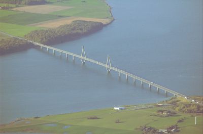
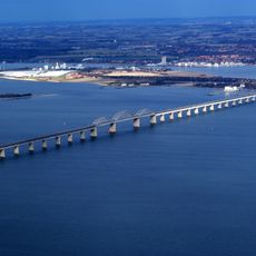
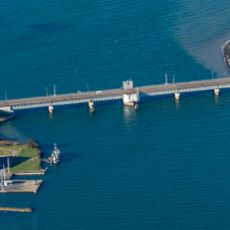
The Farø Bridges are two connected structures spanning 3,322 meters across the Storstrømmen sound between Zealand and Falster islands, passing through Farø island. The southern span uses a cable-stayed design with distinctive diamond-shaped towers, while the northern section relies on beam-girder construction with regular column supports.

History

Construction began in 1984 and the structures were officially inaugurated by Queen Margrethe II in 1985, significantly improving transportation between the islands. This project marked a turning point in Denmark's southern infrastructure development and regional connectivity.

Culture

The bridges serve as a daily passage for people commuting between the islands and have become a familiar landmark in the region's landscape. They represent the practical connection that enables economic activity and social ties between communities that were once more isolated from each other.

Practical

The bridges form part of European routes E47 and E55, serving as the main transport corridor for all types of vehicles between the islands. The crossing is best experienced during clear weather when visibility across the sound allows you to see the structure and surrounding landscape properly.

Did you know?

The southern bridge span features a 290-meter main opening supported by cables, showcasing a completely different engineering approach from the northern section. This technical contrast between two distinct construction methods within a single system becomes visually apparent as you cross.

Inception
1984
Official opening
June 4, 1985
Height
23 m
Length
3,322 m
Longest Span
290 m
Made from material
reinforced concrete
GPS coordinates
54.95093,11.98712
Latest update
December 8, 2025 19:52

AroundUs brings together thousands of curated places, local tips, and hidden gems, enriched daily by 60,000 contributors worldwide. Discover all places nearby (Vordingborg Municipality).

« Farø Bridges - Road bridges system in Vordingborg Municipality, Denmark » is provided by Around Us (aroundus.com). Images and texts are derived from Wikimedia project under a Creative Commons license. You are allowed to copy, distribute, and modify copies of this page, under the conditions set by the license, as long as this note is clearly visible.

Discover hidden gems everywhere you go!

From secret cafés to breathtaking viewpoints, skip the crowded tourist spots and find places that match your style. Our app makes it easy with voice search, smart filtering, route optimization, and insider tips from travelers worldwide. Download now for the complete mobile experience.

Around Us App Screenshot

A unique approach to discovering new places

Le Figaro

All the places worth exploring

France Info

A tailor-made excursion in just a few clicks

20 Minutes

Around Us
Travel Guide & Maps
Download

Send to your phone

QR Code
1

Open the camera app on your mobile.

2

Point at the QR code with your camera. A notification will appear.

3

Tap the notification to open the link.