Enable Location

We need your location to show you interesting places around you

Discover nearby places

Find interesting locations and hidden gems around you

Precise directions

Get accurate directions and distances to places

Your location is never shared with other users. It's only used when you tap the location button.

Slieve Croob

Log in to your account

Start exploring — it's free

Trusted by 62,473 travelers worldwide

Continue with Google
Continue with Apple
or

We will send you a code to connect

By continuing, you accept our Terms and Conditions and our Privacy Policy

Check your inbox

We've sent a pincode in your inbox. Please enter the code below.

Slieve Croob

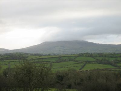
Slieve Croob, Mountain summit in County Down, Northern Ireland

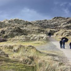
Slieve Croob is a mountain summit in the Dromara Hills standing at 534 meters tall, with a tarmac path climbing to the peak where communication towers are located. The route travels through open countryside with views across County Down's landscape.

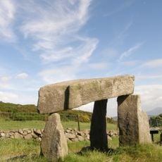
The summit holds an ancient burial cairn with roots reaching back centuries into the past. This archaeological site suggests the mountain held spiritual and ceremonial importance for the people who lived in this region long ago.

Local people gather here on the first Sunday of August for Cairn Sunday, when they carry stones to the summit in honor of twelve Kings believed to be buried at the peak.

A car park at Dree Hill serves as the starting point for the hike to the summit. The paved path makes the walk manageable for most people, and the round trip takes roughly two hours to complete.

This mountain marks the origin of the River Lagan, a river that flows through County Down and eventually reaches Belfast harbor. Few visitors realize they stand at the source of a waterway significant to the region's geography and history.

The community of curious travelers

AroundUs brings together thousands of curated places, local tips, and hidden gems, enriched daily by 60,000 contributors worldwide.

Start exploring
Elevation above the sea
534 m
GPS coordinates
54.34006,-5.97340
Latest update
December 10, 2025 15:49
Around this place
Hillsborough Castle
United Kingdom

Hillsborough Castle

15.3 km
Tollymore Forest Park
United Kingdom

Tollymore Forest Park

14.3 km
Royal County Down Golf Club
United Kingdom

Royal County Down Golf Club

14.7 km
Castlewellan Forest Park
United Kingdom

Castlewellan Forest Park

8.4 km
Legananny Dolmen
United Kingdom

Legananny Dolmen

3.6 km
Murlough Nature Reserve
United Kingdom

Murlough Nature Reserve

14.2 km
Rowallane Garden
United Kingdom

Rowallane Garden

15.2 km
Clough Castle
United Kingdom

Clough Castle

10.7 km
Dromore Cathedral
United Kingdom

Dromore Cathedral

14.2 km
Annadorn Dolmen
United Kingdom

Annadorn Dolmen

11 km
Burrenwood
United Kingdom

Burrenwood

10.6 km
Dromore Viaduct
United Kingdom

Dromore Viaduct

14.7 km
Ballynahinch Market House
United Kingdom

Ballynahinch Market House

8.5 km
Dromore Town Hall
United Kingdom

Dromore Town Hall

14.1 km
Castlewellan Castle Castlewellan Co.down
United Kingdom

Castlewellan Castle Castlewellan Co.down

8.5 km
Peace Maze at Castlewellan Forest Park
United Kingdom

Peace Maze at Castlewellan Forest Park

9.2 km
Kilcoo C Of I Parish Church Bryansford Village Ballyhafry Newcastle Co Down Bt33 0pt
United Kingdom

Kilcoo C Of I Parish Church Bryansford Village Ballyhafry Newcastle Co Down Bt33 0pt

12.5 km
8 The Square Hillsborough County Down Bt26 6ag
United Kingdom

8 The Square Hillsborough County Down Bt26 6ag

15.2 km
Slidderyford Bridge (the Twelve Arches) Old Ballynahinch Road Wateresk Dundrum Newcastle Co.down
United Kingdom

Slidderyford Bridge (the Twelve Arches) Old Ballynahinch Road Wateresk Dundrum Newcastle Co.down

13.5 km
Summer House Hillsborough Castle The Square Hillsborough County Down Bt26 6ag
United Kingdom

Summer House Hillsborough Castle The Square Hillsborough County Down Bt26 6ag

15.3 km
Murland Tomb Clough Non-subscribing Presbyterian Church Castlewellan Road Clough Downpatrick Co Down
United Kingdom

Murland Tomb Clough Non-subscribing Presbyterian Church Castlewellan Road Clough Downpatrick Co Down

10.4 km
Newcastle Library
United Kingdom

Newcastle Library

15.4 km
Clough Non-subscribing Presbyterian Church Castlewellan Road Clough Downpatrick Co Down Bt30 8rd
United Kingdom

Clough Non-subscribing Presbyterian Church Castlewellan Road Clough Downpatrick Co Down Bt30 8rd

10.4 km
Marquis Of Downshire Monument Monument Road Hillsborough Co.down
United Kingdom

Marquis Of Downshire Monument Monument Road Hillsborough Co.down

15.1 km
St Malachy's Hillsborough Parish Church
United Kingdom

St Malachy's Hillsborough Parish Church

15.2 km
Hill House 35 Main St. Hillsborough Co. Down
United Kingdom

Hill House 35 Main St. Hillsborough Co. Down

15.3 km
Trevor House 9 The Square Hillsborough Co. Down Bt26 6ag
United Kingdom

Trevor House 9 The Square Hillsborough Co. Down Bt26 6ag

15.2 km
Magheraknock
United Kingdom

Magheraknock

10.8 km
Show the full map
« Slieve Croob - Mountain summit in County Down, Northern Ireland » is provided by Around Us (aroundus.com). Images and texts are derived from Wikimedia project under a Creative Commons license. You are allowed to copy, distribute, and modify copies of this page, under the conditions set by the license, as long as this note is clearly visible.

Discover hidden gems everywhere you go!

From secret cafés to breathtaking viewpoints, skip the crowded tourist spots and find places that match your style. Our app makes it easy with voice search, smart filtering, route optimization, and insider tips from travelers worldwide. Download now for the complete mobile experience.

Around Us App Screenshot

A unique approach to discovering new places

Le Figaro

All the places worth exploring

France Info

A tailor-made excursion in just a few clicks

20 Minutes

Around Us
Travel Guide & Maps
Download

Send to your phone

QR Code
1

Open the camera app on your mobile.

2

Point at the QR code with your camera. A notification will appear.

3

Tap the notification to open the link.