Enable Location

We need your location to show you interesting places around you

Discover nearby places

Find interesting locations and hidden gems around you

Precise directions

Get accurate directions and distances to places

Your location is never shared with other users. It's only used when you tap the location button.

Burrenwood

Log in to your account

Start exploring — it's free

Trusted by 61,414 travelers worldwide

Continue with Google
Continue with Apple
or

We will send you a code to connect

By continuing, you accept our Terms and Conditions and our Privacy Policy

Check your inbox

We've sent a pincode in your inbox. Please enter the code below.

Burrenwood

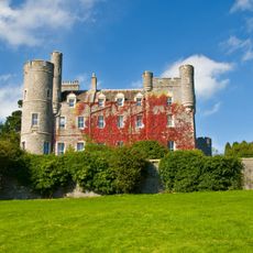
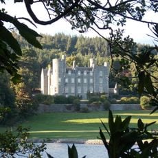
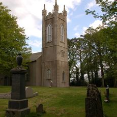
Burrenwood, Historic estate near Castlewellan, Northern Ireland

Description

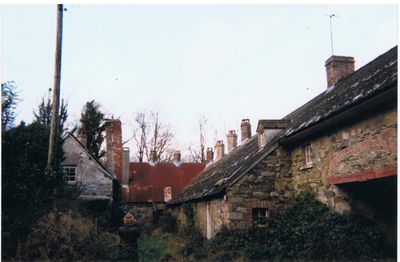
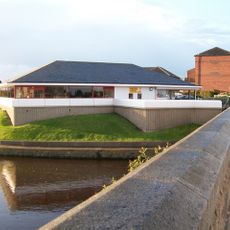
Burrenwood is a countryside estate near Castlewellan set within wooded grounds that feature the Burren River running through the landscape. The horseshoe-shaped main house contains living spaces, bedrooms, a kitchen and office across two levels, with stables positioned nearby on the property.

History

The estate was created in the late 18th century by the Countess of Clanwilliam as an ornamental retreat into woodland. It represents a period when wealthy families designed private estates to reflect romantic visions of an idealized rural life.

Culture

The property displays cottage orné style with thatched roofs, rough stonework, and vegetation-draped porches that reflect romantic ideals of rural retreat. These architectural choices tell a story about how wealthy landowners of the period wanted to present themselves as connected to nature and pastoral life.

Practical

The property is best explored on foot, allowing visitors to walk through wooded grounds and along the river setting. The scattered buildings take time to view properly, so comfortable shoes and weather protection are sensible choices.

Did you know?

The house was built in just six weeks, an unusually rapid pace for construction of this kind during that era. Similar design ideas appear in the Swiss Cottage at Cahir, showing how these romantic estate concepts spread across different regions.

GPS coordinates
54.24600,-5.94400
Latest update
December 14, 2025 18:11

AroundUs brings together thousands of curated places, local tips, and hidden gems, enriched daily by 60,000 contributors worldwide. Discover all places nearby (United Kingdom).

Around this place
Slieve Donard
United Kingdom

Slieve Donard

7.5 km
Tollymore Forest Park
United Kingdom

Tollymore Forest Park

3.8 km
Royal County Down Golf Club
United Kingdom

Royal County Down Golf Club

5 km
Mourne Wall
United Kingdom

Mourne Wall

12.5 km
Slieve Croob
United Kingdom

Slieve Croob

10.6 km
Slieve Binnian
United Kingdom

Slieve Binnian

11.8 km
Castlewellan Forest Park
United Kingdom

Castlewellan Forest Park

2.3 km
Slieve Commedagh
United Kingdom

Slieve Commedagh

6.4 km
Legananny Dolmen
United Kingdom

Legananny Dolmen

9.9 km
Slieve Bearnagh
United Kingdom

Slieve Bearnagh

7.5 km
Murlough Nature Reserve
United Kingdom

Murlough Nature Reserve

6.1 km
Clough Castle
United Kingdom

Clough Castle

8.8 km
Ben Crom Reservoir
United Kingdom

Ben Crom Reservoir

10.5 km
Ben Crom
United Kingdom

Ben Crom

9.4 km
Donard Park
United Kingdom

Donard Park

5.4 km
Slieve Meelmore
United Kingdom

Slieve Meelmore

7.3 km
Goward Dolmen
United Kingdom

Goward Dolmen

10.5 km
Slieve Meelbeg
United Kingdom

Slieve Meelbeg

8.1 km
Castlewellan Castle Castlewellan Co.down
United Kingdom

Castlewellan Castle Castlewellan Co.down

2.2 km
Peace Maze at Castlewellan Forest Park
United Kingdom

Peace Maze at Castlewellan Forest Park

1.5 km
Kilcoo C Of I Parish Church Bryansford Village Ballyhafry Newcastle Co Down Bt33 0pt
United Kingdom

Kilcoo C Of I Parish Church Bryansford Village Ballyhafry Newcastle Co Down Bt33 0pt

1.9 km
Clough Non-subscribing Presbyterian Church Castlewellan Road Clough Downpatrick Co Down Bt30 8rd
United Kingdom

Clough Non-subscribing Presbyterian Church Castlewellan Road Clough Downpatrick Co Down Bt30 8rd

8.4 km
Murland Tomb Clough Non-subscribing Presbyterian Church Castlewellan Road Clough Downpatrick Co Down
United Kingdom

Murland Tomb Clough Non-subscribing Presbyterian Church Castlewellan Road Clough Downpatrick Co Down

8.4 km
Slidderyford Bridge (the Twelve Arches) Old Ballynahinch Road Wateresk Dundrum Newcastle Co.down
United Kingdom

Slidderyford Bridge (the Twelve Arches) Old Ballynahinch Road Wateresk Dundrum Newcastle Co.down

5.5 km
Newcastle Library
United Kingdom

Newcastle Library

5.2 km
Overflow Pipe Silent Valley Reservoir Head Road Kilkeel Newry Co Down Bt34 4pu
United Kingdom

Overflow Pipe Silent Valley Reservoir Head Road Kilkeel Newry Co Down Bt34 4pu

13.6 km
Silent Valley Reservoir
United Kingdom

Silent Valley Reservoir

13.1 km
Spelga Reservoir
United Kingdom

Spelga Reservoir

11.1 km
Show the full map
« Burrenwood - Historic estate near Castlewellan, Northern Ireland » is provided by Around Us (aroundus.com). Images and texts are derived from Wikimedia project under a Creative Commons license. You are allowed to copy, distribute, and modify copies of this page, under the conditions set by the license, as long as this note is clearly visible.

Discover hidden gems everywhere you go!

From secret cafés to breathtaking viewpoints, skip the crowded tourist spots and find places that match your style. Our app makes it easy with voice search, smart filtering, route optimization, and insider tips from travelers worldwide. Download now for the complete mobile experience.

Around Us App Screenshot

A unique approach to discovering new places

Le Figaro

All the places worth exploring

France Info

A tailor-made excursion in just a few clicks

20 Minutes

Around Us
Travel Guide & Maps
Download

Send to your phone

QR Code
1

Open the camera app on your mobile.

2

Point at the QR code with your camera. A notification will appear.

3

Tap the notification to open the link.