Slieve Commedagh

Log in to your account

AroundUs is a community-driven map of interesting places, built by curious explorers like you. It grows with every review, story, and photo you share.
Connect to save your favorite spots, contribute locations, and create personalized routes.
By continuing, you accept our Terms and Conditions and our Privacy Policy

Slieve Commedagh

Add to collection
Map
Suggest a change
Share

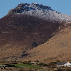
Slieve Commedagh, Mountain summit in County Down, Northern Ireland.

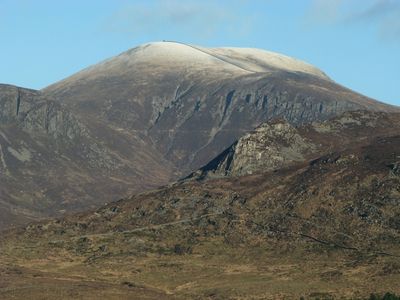
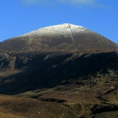
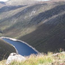
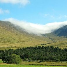
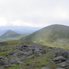
Slieve Commedagh is a mountain summit in the Mourne Mountains rising to about 767 meters and marked by steep slopes and granite formations. The peak can be approached through several different walking paths and routes.

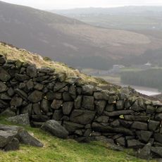
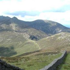
In the early 1900s, the Mourne Wall was built across the summit to mark the boundary of a water catchment area. This stone wall remains a defining feature of the mountain today.

The mountain's name comes from Irish and means 'mountain of the watchers'. People have long used this summit as a key viewpoint over the surrounding territory and landscape.

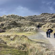
The mountain can be reached through several walking routes, including the Glen River Track and the Hare's Gap route, with the climb taking roughly 2.5 hours. The terrain is rocky and uneven, so sturdy walking boots and appropriate gear are important.

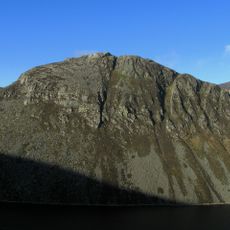
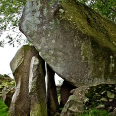
The southern face features distinctive granite rock formations locally called 'the Castles' that stand out like stone towers against the heather-covered slopes. These striking rock formations make the southern side of the summit instantly recognizable.

Location: Northern Ireland

Elevation above the sea: 767 m

GPS coordinates: 54.18885,-5.93858

Latest update: December 11, 2025 18:01

Photos
Around this place
Slieve Donard
United Kingdom

Slieve Donard

1.5 km
Tollymore Forest Park
United Kingdom

Tollymore Forest Park

3.3 km
Royal County Down Golf Club
United Kingdom

Royal County Down Golf Club

4.9 km
Mourne Wall
United Kingdom

Mourne Wall

7 km
Slieve Binnian
United Kingdom

Slieve Binnian

5.9 km
Castlewellan Forest Park
United Kingdom

Castlewellan Forest Park

8.6 km
Slieve Bearnagh
United Kingdom

Slieve Bearnagh

3.3 km
Murlough Nature Reserve
United Kingdom

Murlough Nature Reserve

7.5 km
Clough Castle
United Kingdom

Clough Castle

13.3 km
Ben Crom Reservoir
United Kingdom

Ben Crom Reservoir

5.1 km
Ben Crom
United Kingdom

Ben Crom

4.2 km
Donard Park
United Kingdom

Donard Park

2.9 km
Slieve Meelmore
United Kingdom

Slieve Meelmore

4 km
Goward Dolmen
United Kingdom

Goward Dolmen

10.5 km
Burrenwood
United Kingdom

Burrenwood

6.4 km
Slieve Meelbeg
United Kingdom

Slieve Meelbeg

4.6 km
Rathfriland Castle
United Kingdom

Rathfriland Castle

15.3 km
Castlewellan Castle Castlewellan Co.down
United Kingdom

Castlewellan Castle Castlewellan Co.down

8.5 km
Annalong Cornmill
United Kingdom

Annalong Cornmill

9.3 km
Peace Maze at Castlewellan Forest Park
United Kingdom

Peace Maze at Castlewellan Forest Park

7.8 km
Kilcoo C Of I Parish Church Bryansford Village Ballyhafry Newcastle Co Down Bt33 0pt
United Kingdom

Kilcoo C Of I Parish Church Bryansford Village Ballyhafry Newcastle Co Down Bt33 0pt

4.5 km
Slidderyford Bridge (the Twelve Arches) Old Ballynahinch Road Wateresk Dundrum Newcastle Co.down
United Kingdom

Slidderyford Bridge (the Twelve Arches) Old Ballynahinch Road Wateresk Dundrum Newcastle Co.down

7.4 km
Clough Non-subscribing Presbyterian Church Castlewellan Road Clough Downpatrick Co Down Bt30 8rd
United Kingdom

Clough Non-subscribing Presbyterian Church Castlewellan Road Clough Downpatrick Co Down Bt30 8rd

13 km
Murland Tomb Clough Non-subscribing Presbyterian Church Castlewellan Road Clough Downpatrick Co Down
United Kingdom

Murland Tomb Clough Non-subscribing Presbyterian Church Castlewellan Road Clough Downpatrick Co Down

13 km
Newcastle Library
United Kingdom

Newcastle Library

3.9 km
Overflow Pipe Silent Valley Reservoir Head Road Kilkeel Newry Co Down Bt34 4pu
United Kingdom

Overflow Pipe Silent Valley Reservoir Head Road Kilkeel Newry Co Down Bt34 4pu

7.8 km
Annalong Corn Mill The Harbour Annalong Newry Co Down Bt34 4as
United Kingdom

Annalong Corn Mill The Harbour Annalong Newry Co Down Bt34 4as

9.3 km
Spelga Reservoir
United Kingdom

Spelga Reservoir

8.1 km
Show the full map
Reviews

Visited this place? Tap the stars to rate it and share your experience / photos with the community! Try now! You can cancel it anytime.

« Slieve Commedagh - Mountain summit in County Down, Northern Ireland » is provided by Around Us (aroundus.com). Images and texts are derived from Wikimedia project under a Creative Commons license. You are allowed to copy, distribute, and modify copies of this page, under the conditions set by the license, as long as this note is clearly visible.

Discover hidden gems everywhere you go!

From secret cafés to breathtaking viewpoints, skip the crowded tourist spots and find places that match your style. Our app makes it easy with voice search, smart filtering, route optimization, and insider tips from travelers worldwide. Download now for the complete mobile experience.

Around Us App Screenshot

A unique approach to discovering new places

Le Figaro

All the places worth exploring

France Info

A tailor-made excursion in just a few clicks

20 Minutes