Enable Location

We need your location to show you interesting places around you

Discover nearby places

Find interesting locations and hidden gems around you

Precise directions

Get accurate directions and distances to places

Your location is never shared with other users. It's only used when you tap the location button.

Slieve Bearnagh

Log in to your account

Start exploring — it's free

Trusted by 61,351 travelers worldwide

Continue with Google
Continue with Apple
or

We will send you a code to connect

By continuing, you accept our Terms and Conditions and our Privacy Policy

Check your inbox

We've sent a pincode in your inbox. Please enter the code below.

Slieve Bearnagh

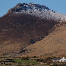
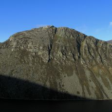
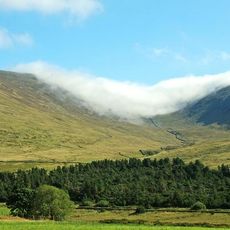
Slieve Bearnagh, Mountain summit in County Down, United Kingdom.

Description

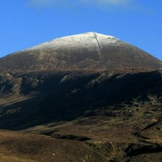
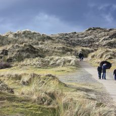
Slieve Bearnagh is a mountain in the Mourne Mountains standing at 727 meters, characterized by two distinct granite tors at its peak. The summit area features rocky terrain with well-worn hiking paths that connect the main features of the ridge.

History

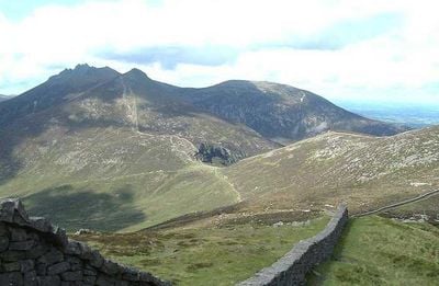
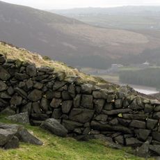
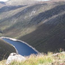
The Mourne Wall was built in the early twentieth century to mark water catchment boundaries, passing directly across the mountain's summit. This structure remains a prominent feature of the landscape and marks an important period of regional infrastructure development.

Culture

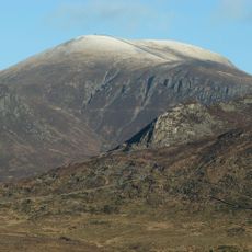
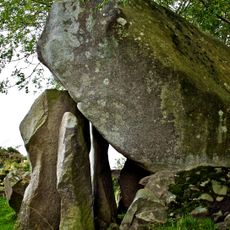
The name derives from Irish Gaelic 'Sliabh Bearna', meaning 'mountain of the gap', which directly describes the striking opening between its two granite tors. Visitors walking across the summit experience this geographical feature that inspired the mountain's identity.

Practical

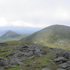
Multiple established paths lead to the summit, with Trassey Track and Meelmore Lodge providing convenient starting points for hikers. The routes are accessible year-round, though wet conditions require sturdy footwear and careful navigation over uneven ground.

Did you know?

The two granite tors at the summit create a challenging gap that requires climbing skills to reach the highest points. This technical feature is what inspired the mountain's name and makes it a memorable destination for experienced hikers.

Location
Elevation above the sea
727 m
GPS coordinates
54.18406,-5.98889
Latest update
December 12, 2025 07:54

AroundUs brings together thousands of curated places, local tips, and hidden gems, enriched daily by 60,000 contributors worldwide. Discover all places nearby (County Down).

Around this place
Slieve Donard
United Kingdom

Slieve Donard

4.4 km
Tollymore Forest Park
United Kingdom

Tollymore Forest Park

5.9 km
Royal County Down Golf Club
United Kingdom

Royal County Down Golf Club

7.9 km
Mourne Wall
United Kingdom

Mourne Wall

5.1 km
Slieve Binnian
United Kingdom

Slieve Binnian

4.7 km
Castlewellan Forest Park
United Kingdom

Castlewellan Forest Park

9.3 km
Slieve Commedagh
United Kingdom

Slieve Commedagh

3.3 km
Legananny Dolmen
United Kingdom

Legananny Dolmen

15.6 km
Murlough Nature Reserve
United Kingdom

Murlough Nature Reserve

10.5 km
Ben Crom Reservoir
United Kingdom

Ben Crom Reservoir

3.1 km
Ben Crom
United Kingdom

Ben Crom

2 km
Donard Park
United Kingdom

Donard Park

6 km
Slieve Meelmore
United Kingdom

Slieve Meelmore

979 m
Goward Dolmen
United Kingdom

Goward Dolmen

7.6 km
Burrenwood
United Kingdom

Burrenwood

7.5 km
Slieve Meelbeg
United Kingdom

Slieve Meelbeg

1.3 km
Rathfriland Castle
United Kingdom

Rathfriland Castle

12.6 km
Castlewellan Castle Castlewellan Co.down
United Kingdom

Castlewellan Castle Castlewellan Co.down

9.2 km
Annalong Cornmill
United Kingdom

Annalong Cornmill

10.3 km
Peace Maze at Castlewellan Forest Park
United Kingdom

Peace Maze at Castlewellan Forest Park

8.6 km
Kilcoo C Of I Parish Church Bryansford Village Ballyhafry Newcastle Co Down Bt33 0pt
United Kingdom

Kilcoo C Of I Parish Church Bryansford Village Ballyhafry Newcastle Co Down Bt33 0pt

6.1 km
Murland Tomb Clough Non-subscribing Presbyterian Church Castlewellan Road Clough Downpatrick Co Down
United Kingdom

Murland Tomb Clough Non-subscribing Presbyterian Church Castlewellan Road Clough Downpatrick Co Down

15.3 km
Clough Non-subscribing Presbyterian Church Castlewellan Road Clough Downpatrick Co Down Bt30 8rd
United Kingdom

Clough Non-subscribing Presbyterian Church Castlewellan Road Clough Downpatrick Co Down Bt30 8rd

15.3 km
Slidderyford Bridge (the Twelve Arches) Old Ballynahinch Road Wateresk Dundrum Newcastle Co.down
United Kingdom

Slidderyford Bridge (the Twelve Arches) Old Ballynahinch Road Wateresk Dundrum Newcastle Co.down

10.2 km
Newcastle Library
United Kingdom

Newcastle Library

7 km
Overflow Pipe Silent Valley Reservoir Head Road Kilkeel Newry Co Down Bt34 4pu
United Kingdom

Overflow Pipe Silent Valley Reservoir Head Road Kilkeel Newry Co Down Bt34 4pu

6.2 km
Annalong Corn Mill The Harbour Annalong Newry Co Down Bt34 4as
United Kingdom

Annalong Corn Mill The Harbour Annalong Newry Co Down Bt34 4as

10.3 km
Silent Valley Reservoir
United Kingdom

Silent Valley Reservoir

5.7 km
Show the full map
« Slieve Bearnagh - Mountain summit in County Down, United Kingdom » is provided by Around Us (aroundus.com). Images and texts are derived from Wikimedia project under a Creative Commons license. You are allowed to copy, distribute, and modify copies of this page, under the conditions set by the license, as long as this note is clearly visible.

Discover hidden gems everywhere you go!

From secret cafés to breathtaking viewpoints, skip the crowded tourist spots and find places that match your style. Our app makes it easy with voice search, smart filtering, route optimization, and insider tips from travelers worldwide. Download now for the complete mobile experience.

Around Us App Screenshot

A unique approach to discovering new places

Le Figaro

All the places worth exploring

France Info

A tailor-made excursion in just a few clicks

20 Minutes

Around Us
Travel Guide & Maps
Download

Send to your phone

QR Code
1

Open the camera app on your mobile.

2

Point at the QR code with your camera. A notification will appear.

3

Tap the notification to open the link.