Enable Location

We need your location to show you interesting places around you

Discover nearby places

Find interesting locations and hidden gems around you

Precise directions

Get accurate directions and distances to places

Your location is never shared with other users. It's only used when you tap the location button.

Dunnichen Stone

Log in to your account

Start exploring — it's free

Trusted by 62,839 travelers worldwide

Continue with Google
Continue with Apple
or

We will send you a code to connect

By continuing, you accept our Terms and Conditions and our Privacy Policy

Check your inbox

We've sent a pincode in your inbox. Please enter the code below.

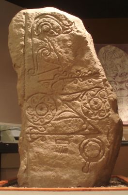
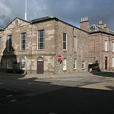
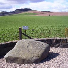
Dunnichen Stone, 7th century Pictish stone at Meffan Institute, Scotland.

The Dunnichen Stone is a 7th century sandstone monument with carvings from the Pictish era, now housed at the Meffan Institute in Forfar. Its surface displays various motifs including a flower, double discs, a Z-shaped symbol, a mirror, and comb patterns typical of stones from this period.

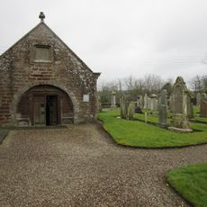
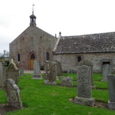
The stone was discovered in 1811 in a field near Dunnichen and subsequently moved to several locations. It eventually came to rest at the Meffan Institute, while a replica was placed at Dunnichen Church to preserve the site's connection to its history.

The carved symbols on the sandstone show how the Picts represented their world and what mattered to them. These marks tell us about the beliefs and daily life of people who lived here over a thousand years ago.

The stone is located at the Meffan Institute in Forfar where visitors can view it up close to examine the carvings. A replica stands at the original site near Dunnichen Church if you want to visit where it was originally found.

The flower motif on this stone is remarkably rare among all known Pictish monuments, making it especially valuable for understanding Pictish artistic traditions. This single symbol stands out clearly from the standardized marks found on most other stones from the same era.

The community of curious travelers

AroundUs brings together thousands of curated places, local tips, and hidden gems, enriched daily by 60,000 contributors worldwide.

Start exploring
Location
GPS coordinates
56.62812,-2.80155
Latest update
December 8, 2025 21:05
Around this place
Guthrie Castle
United Kingdom

Guthrie Castle

5.6 km
Aberlemno Sculptured Stones
United Kingdom

Aberlemno Sculptured Stones

6.9 km
Station Park
United Kingdom

Station Park

5.8 km
Meffan Institute
United Kingdom

Meffan Institute

5.6 km
Restenneth Priory
United Kingdom

Restenneth Priory

3.9 km
Gardyne Castle
United Kingdom

Gardyne Castle

6.4 km
County Buildings, Market Street, Forfar
United Kingdom

County Buildings, Market Street, Forfar

5.7 km
Forfar Town and County Hall
United Kingdom

Forfar Town and County Hall

5.6 km
Forfar, Market Street, Sheriff Court House
United Kingdom

Forfar, Market Street, Sheriff Court House

5.8 km
Forfar, Castle Street, Municipal Buildings
United Kingdom

Forfar, Castle Street, Municipal Buildings

5.6 km
Pitmuies House
United Kingdom

Pitmuies House

5.9 km
Forfar, Montrose Road, Lowson Memorial Church
United Kingdom

Forfar, Montrose Road, Lowson Memorial Church

4.9 km
Girdle Stane
United Kingdom

Girdle Stane

2.1 km
Forfar, St James' Road, St James's Church
United Kingdom

Forfar, St James' Road, St James's Church

5.4 km
Guthrie Collegiate Aisle
United Kingdom

Guthrie Collegiate Aisle

6 km
Forfar, 23 Osnaburg Street
United Kingdom

Forfar, 23 Osnaburg Street

5.6 km
Rescobie Parish Kirk And Churchyard
United Kingdom

Rescobie Parish Kirk And Churchyard

3.3 km
Guthrie Parish Church And Churchyard
United Kingdom

Guthrie Parish Church And Churchyard

6.1 km
Forfar, 71 East High Street, St John's Episcopal Church
United Kingdom

Forfar, 71 East High Street, St John's Episcopal Church

5.5 km
Forfar, Academy Street, Chapelpark Primary School, Main Block
United Kingdom

Forfar, Academy Street, Chapelpark Primary School, Main Block

5.3 km
Pitmuies, Over Bridge
United Kingdom

Pitmuies, Over Bridge

5.9 km
Carmyllie, Primary School
United Kingdom

Carmyllie, Primary School

6.9 km
Auldbar Road, Balgavies, (former Station House) Including Stable, Signal Box, Platform, External Staircase, Railings And  Retain
United Kingdom

Auldbar Road, Balgavies, (former Station House) Including Stable, Signal Box, Platform, External Staircase, Railings And Retain

3.6 km
Holemill, Old Corn Mill
United Kingdom

Holemill, Old Corn Mill

5.8 km
Guthrie Castle, Railway Bridge
United Kingdom

Guthrie Castle, Railway Bridge

5.2 km
Signal Box, Auldbar Road Station
United Kingdom

Signal Box, Auldbar Road Station

3.6 km
Guthrie Churchyard, Gateway
United Kingdom

Guthrie Churchyard, Gateway

6 km
Reid Park bandstand
United Kingdom

Reid Park bandstand

5.3 km
Show the full map
« Dunnichen Stone - 7th century Pictish stone at Meffan Institute, Scotland » is provided by Around Us (aroundus.com). Images and texts are derived from Wikimedia project under a Creative Commons license. You are allowed to copy, distribute, and modify copies of this page, under the conditions set by the license, as long as this note is clearly visible.

Discover hidden gems everywhere you go!

From secret cafés to breathtaking viewpoints, skip the crowded tourist spots and find places that match your style. Our app makes it easy with voice search, smart filtering, route optimization, and insider tips from travelers worldwide. Download now for the complete mobile experience.

Around Us App Screenshot

A unique approach to discovering new places

Le Figaro

All the places worth exploring

France Info

A tailor-made excursion in just a few clicks

20 Minutes

Around Us
Travel Guide & Maps
Download

Send to your phone

QR Code
1

Open the camera app on your mobile.

2

Point at the QR code with your camera. A notification will appear.

3

Tap the notification to open the link.