Preston Tower

Log in to your account

AroundUs is a community-driven map of interesting places, built by curious explorers like you. It grows with every review, story, and photo you share.
Connect to save your favorite spots, contribute locations, and create personalized routes.
Continue with Google
Continue with Apple
Continue with X
Continue with Facebook
Continue with email
By continuing, you accept our Terms and Conditions and our Privacy Policy
Create an account
Add to collection
Map
Suggest a change
Share

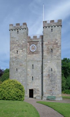
Preston Tower, Medieval defensive tower in Ellingham, England

Preston Tower is a fortified residence with thick stone walls and narrow window openings located in Ellingham. The structure appears smaller than its original size because stones were removed during the 17th century, though the interior rooms are furnished to show medieval-era living conditions.

The tower was built in 1392 as a fortified structure to protect against conflicts between England and Scotland along the borderlands. This defensive function continued until 1603, when the immediate threats diminished and the tower's role in regional defense gradually changed.

The tower represents how people in medieval Northumberland built their homes to stay safe during uncertain times. Walking through it today, you can see how families lived and worked in these stone structures.

You can reach the tower on foot from the parking area near the entrance. Wear comfortable shoes because the interior stairs are steep and narrow, and climbing to the upper levels requires some agility.

The roof of the tower offers views across Northumberland's landscape, revealing why these elevated positions were so important for surveillance. From this vantage point, residents could spot threats coming from a distance and respond to danger early.

Location: Ellingham

Website: https://prestontower.co.uk

GPS coordinates: 55.52230,-1.71054

Latest update: December 12, 2025 12:04

Photos
Around this place
Embleton Tower
United Kingdom

Embleton Tower

5.5 km
Rock Hall
United Kingdom

Rock Hall

5.4 km
Ellingham Hall, Northumberland
United Kingdom

Ellingham Hall, Northumberland

1.2 km
Charlton Hall
United Kingdom

Charlton Hall

3.1 km
Church of the Holy Trinity, Embleton
United Kingdom

Church of the Holy Trinity, Embleton

5.5 km
Church of St Maurice
United Kingdom

Church of St Maurice

840 m
Church of St James
United Kingdom

Church of St James

5.5 km
Embleton United Reformed Church
United Kingdom

Embleton United Reformed Church

5.6 km
Church of Saints Philip and James
United Kingdom

Church of Saints Philip and James

5.5 km
Saint Mary the Virgin
United Kingdom

Saint Mary the Virgin

5.6 km
Doxford Farmhouse
United Kingdom

Doxford Farmhouse

2.2 km
Village Pump
United Kingdom

Village Pump

5.5 km
Waiting Shed And Up Platform At Chathill Station
United Kingdom

Waiting Shed And Up Platform At Chathill Station

1.6 km
Milepost Circa 200 Yards South Of Newstead Road End
United Kingdom

Milepost Circa 200 Yards South Of Newstead Road End

3.7 km
Cup and ring marked rocks on Wandylaw Moor, 1km west of Wandylaw
United Kingdom

Cup and ring marked rocks on Wandylaw Moor, 1km west of Wandylaw

4.6 km
Milepost 100 Metres South Of Newtonbarns
United Kingdom

Milepost 100 Metres South Of Newtonbarns

4 km
Preston Tower (New)
United Kingdom

Preston Tower (New)

73 m
South Lodge And Gateway To Preston Tower
United Kingdom

South Lodge And Gateway To Preston Tower

221 m
Chathill Station And Down Platform
United Kingdom

Chathill Station And Down Platform

1.6 km
Signal Box At Chathill Station
United Kingdom

Signal Box At Chathill Station

1.6 km
Cross On North Side Of B6347 120 Metres West Of A1 Junction
United Kingdom

Cross On North Side Of B6347 120 Metres West Of A1 Junction

2.9 km
Former Goods Shed On East Of Railway Immediately North Of B 1340
United Kingdom

Former Goods Shed On East Of Railway Immediately North Of B 1340

3.8 km
Mile Post 700 Metres North Of Prickly Bridge
United Kingdom

Mile Post 700 Metres North Of Prickly Bridge

4.5 km
North Charlton medieval village and open field system
United Kingdom

North Charlton medieval village and open field system

2.8 km
Milepost, Rayheugh in loop of old road
United Kingdom

Milepost, Rayheugh in loop of old road

5 km
Milepost, North Sunderland
United Kingdom

Milepost, North Sunderland

5.4 km
Milepost, North Charlton, just before dual carriageway, north of Shipperton Bridge
United Kingdom

Milepost, North Charlton, just before dual carriageway, north of Shipperton Bridge

3.4 km
Milepost, Brownieside
United Kingdom

Milepost, Brownieside

2.4 km
Show the full map
Reviews

Visited this place? Tap the stars to rate it and share your experience / photos with the community! Try now! You can cancel it anytime.

« Preston Tower - Medieval defensive tower in Ellingham, England » is provided by Around Us (aroundus.com). Images and texts are derived from Wikimedia project under a Creative Commons license. You are allowed to copy, distribute, and modify copies of this page, under the conditions set by the license, as long as this note is clearly visible.

Discover hidden gems everywhere you go!

From secret cafés to breathtaking viewpoints, skip the crowded tourist spots and find places that match your style. Our app makes it easy with voice search, smart filtering, route optimization, and insider tips from travelers worldwide. Download now for the complete mobile experience.

Around Us App Screenshot

A unique approach to discovering new places

Le Figaro

All the places worth exploring

France Info

A tailor-made excursion in just a few clicks

20 Minutes