·

Enable Location

We need your location to show you interesting places around you

Discover nearby places

Find interesting locations and hidden gems around you

Precise directions

Get accurate directions and distances to places

Your location is never shared with other users. It's only used when you tap the location button.

Donibristle

Log in to your account

Start exploring — it's free

Trusted by 62,656 travelers worldwide

Continue with Google
Continue with Apple
or

We will send you a code to connect

By continuing, you accept our Terms and Conditions and our Privacy Policy

Check your inbox

We've sent a pincode in your inbox. Please enter the code below.

Donibristle

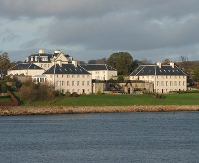
Donibristle, Category A listed building in Fife, Scotland.

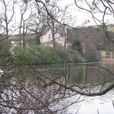
Donibristle House is a stately residence in Fife, Scotland, of which two wings remain standing and connected by an underground passage. Both wings feature ornate wrought-iron screens and sit positioned to overlook the Firth of Forth.

The original fortress burned in 1592, after which a new house was built in 1720 for the Earl of Moray. Another fire struck the structure in 1858, causing significant damage.

The name Donibristle comes from the Scottish Gaelic "dun" meaning fort, reflecting its origins as a fortified site. Today visitors can see how the remaining stone wings frame views toward the water, with the ironwork screens adding decorative character to what was once a grand residence.

The surviving wings have been converted to residential properties, so the site is not open to the public. However, the coastal location makes it worth viewing from walking paths and local viewpoints nearby.

During World Wars I and II, the estate was transformed into a Royal Navy airfield called RNAS Donibristle and served aviation operations. After the wars ended, it returned to residential use, making this military chapter easy to overlook today.

The community of curious travelers

AroundUs brings together thousands of curated places, local tips, and hidden gems, enriched daily by 60,000 contributors worldwide.

Start exploring
Location
Location
GPS coordinates
56.03053,-3.35231
Latest update
December 11, 2025 18:05
Around this place
Fordell Castle
United Kingdom

Fordell Castle

2.8 km
Inchcolm Abbey
United Kingdom

Inchcolm Abbey

3.1 km
Deep Sea World
United Kingdom

Deep Sea World

3.5 km
St Bridget's Kirk, Dalgety Bay
United Kingdom

St Bridget's Kirk, Dalgety Bay

1.5 km
Couston Castle
United Kingdom

Couston Castle

2.5 km
Jamestown Viaduct
United Kingdom

Jamestown Viaduct

3.4 km
Inverkeithing, Townhall Street, Town House
United Kingdom

Inverkeithing, Townhall Street, Town House

2.8 km
Inchcolm Hogback Stone
United Kingdom

Inchcolm Hogback Stone

3.1 km
North Queensferry, Pierhead, Lighthouse
United Kingdom

North Queensferry, Pierhead, Lighthouse

3.6 km
North Queensferry, Pilot Boat Slipway
United Kingdom

North Queensferry, Pilot Boat Slipway

3.6 km
Inverkeithing, 16-18 Church Street, Fordell's Lodging
United Kingdom

Inverkeithing, 16-18 Church Street, Fordell's Lodging

2.8 km
North Queensferry, Town Pier
United Kingdom

North Queensferry, Town Pier

3.7 km
Inverkeithing Museum
United Kingdom

Inverkeithing Museum

2.9 km
Inverkeithing, 2-4 Bank Street, Thomson's Lodging
United Kingdom

Inverkeithing, 2-4 Bank Street, Thomson's Lodging

2.8 km
Inverkeithing, Bank Street, Market Cross
United Kingdom

Inverkeithing, Bank Street, Market Cross

2.8 km
St Colme House, East Lodge
United Kingdom

St Colme House, East Lodge

3.9 km
Inchcolm,  Abbey, hermit's cell, First World War and Second World War defences
United Kingdom

Inchcolm, Abbey, hermit's cell, First World War and Second World War defences

2.9 km
Aberdour, 80-82 High Street, Woodside Hotel
United Kingdom

Aberdour, 80-82 High Street, Woodside Hotel

3.9 km
North Queensferry, Pierhead, Signal House
United Kingdom

North Queensferry, Pierhead, Signal House

3.7 km
North Queensferry, Chapel Place, Clifton House
United Kingdom

North Queensferry, Chapel Place, Clifton House

3.5 km
Inverkeithing, Bowed Truss Railway  Bridge
United Kingdom

Inverkeithing, Bowed Truss Railway Bridge

3.2 km
North Queensferry, 2 Post Office Lane
United Kingdom

North Queensferry, 2 Post Office Lane

3.5 km
Donibristle House
United Kingdom

Donibristle House

200 m
Albert Hotel, 25 Main Street, North Queensferry
United Kingdom

Albert Hotel, 25 Main Street, North Queensferry

3.6 km
North Queensferry, Main Street, Hill House
United Kingdom

North Queensferry, Main Street, Hill House

3.5 km
Footbridge Over Railway, Abbot Place, Inverkeithing
United Kingdom

Footbridge Over Railway, Abbot Place, Inverkeithing

2.8 km
North Queensferry, 26-28 Main Street
United Kingdom

North Queensferry, 26-28 Main Street

3.6 km
Footbridge, Port Street, Inverkeithing
United Kingdom

Footbridge, Port Street, Inverkeithing

2.6 km
Show the full map
« Donibristle - Category A listed building in Fife, Scotland » is provided by Around Us (aroundus.com). Images and texts are derived from Wikimedia project under a Creative Commons license. You are allowed to copy, distribute, and modify copies of this page, under the conditions set by the license, as long as this note is clearly visible.

Discover hidden gems everywhere you go!

From secret cafés to breathtaking viewpoints, skip the crowded tourist spots and find places that match your style. Our app makes it easy with voice search, smart filtering, route optimization, and insider tips from travelers worldwide. Download now for the complete mobile experience.

Around Us App Screenshot

A unique approach to discovering new places

Le Figaro

All the places worth exploring

France Info

A tailor-made excursion in just a few clicks

20 Minutes

Around Us
Travel Guide & Maps
Download

Send to your phone

QR Code
1

Open the camera app on your mobile.

2

Point at the QR code with your camera. A notification will appear.

3

Tap the notification to open the link.