Enable Location

We need your location to show you interesting places around you

Discover nearby places

Find interesting locations and hidden gems around you

Precise directions

Get accurate directions and distances to places

Your location is never shared with other users. It's only used when you tap the location button.

Shotwick Park

Log in to your account

Start exploring — it's free

Trusted by 63,533 travelers worldwide

Continue with Google
Continue with Apple
or

We will send you a code to connect

By continuing, you accept our Terms and Conditions and our Privacy Policy

Check your inbox

We've sent a pincode in your inbox. Please enter the code below.

Shotwick Park
Discussion Reviews 1 Photos
0 Popularity

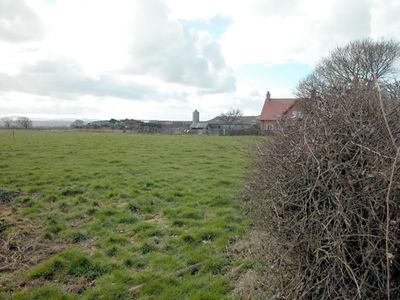
Shotwick Park, former civil parish in Cheshire, United Kingdom

The community of curious travelers

AroundUs brings together thousands of curated places, local tips, and hidden gems, enriched daily by 60,000 contributors worldwide.

Start exploring
GPS coordinates
53.23330,-2.96667
Latest update
April 2, 2025 22:59
Around this place
Shotwick Castle
United Kingdom

Shotwick Castle

924 m
Shotwick House
United Kingdom

Shotwick House

890 m
St Michael's Church, Shotwick
United Kingdom

St Michael's Church, Shotwick

2 km
Shotwick Hall
United Kingdom

Shotwick Hall

2 km
All Saints Church, Great Saughall
United Kingdom

All Saints Church, Great Saughall

1 km
St Bartholomew's Church, Sealand
United Kingdom

St Bartholomew's Church, Sealand

2.3 km
Churchyard boundary wall, Church of St Bartholomew
United Kingdom

Churchyard boundary wall, Church of St Bartholomew

2.3 km
The Old Swinging Gate Inn
United Kingdom

The Old Swinging Gate Inn

1.3 km
Bridge Farmhouse
United Kingdom

Bridge Farmhouse

1.3 km
Gates, gatepiers and churchyard wall along north side of Shotwick Lane
United Kingdom

Gates, gatepiers and churchyard wall along north side of Shotwick Lane

2 km
Front garden walls and gatepiers at Shotwick Hall
United Kingdom

Front garden walls and gatepiers at Shotwick Hall

2.1 km
Tombchest of Robert and Martha Ellison, 10 metres southwest of south corner of tower of Church of St Michael
United Kingdom

Tombchest of Robert and Martha Ellison, 10 metres southwest of south corner of tower of Church of St Michael

2 km
Manor Farmhouse
United Kingdom

Manor Farmhouse

1.9 km
Former kitchen or bakehouse attached to north east corner of Shotwick Hall
United Kingdom

Former kitchen or bakehouse attached to north east corner of Shotwick Hall

2.1 km
Tombchest of John Nevett Bennett, 5 metres west of south porch of St Michael's Church
United Kingdom

Tombchest of John Nevett Bennett, 5 metres west of south porch of St Michael's Church

2 km
L-shaped ranges of farm buildings 60 metres north of Shotwick Hall
United Kingdom

L-shaped ranges of farm buildings 60 metres north of Shotwick Hall

2.1 km
Granary 30 metres east of Shotwicklodge Farmhouse
United Kingdom

Granary 30 metres east of Shotwicklodge Farmhouse

480 m
Sundial in the churchyard of St Michael
United Kingdom

Sundial in the churchyard of St Michael

2 km
Tombchest of James Phillips, 2 metres south of the sundial in the Churchyard of St Michael
United Kingdom

Tombchest of James Phillips, 2 metres south of the sundial in the Churchyard of St Michael

2 km
Tombchest of Rev M Reay and 4 children, 8 metres south of south porch of Church of St Michael
United Kingdom

Tombchest of Rev M Reay and 4 children, 8 metres south of south porch of Church of St Michael

2 km
Greyhound Farmhouse
United Kingdom

Greyhound Farmhouse

1.9 km
Aldersey House
United Kingdom

Aldersey House

1.2 km
Tombchest of William Briscoe (died 1723) and others, 4 metres west of priest's door to St Michael's Church
United Kingdom

Tombchest of William Briscoe (died 1723) and others, 4 metres west of priest's door to St Michael's Church

2 km
Tombchest of William Briscoe (died 1704) and others, 5 metres southwest of priest's door to St Michael's Church
United Kingdom

Tombchest of William Briscoe (died 1704) and others, 5 metres southwest of priest's door to St Michael's Church

2 km
Gibbet Windmill
United Kingdom

Gibbet Windmill

1.3 km
Vicarage Farmhouse
United Kingdom

Vicarage Farmhouse

2 km
Footpath guidepost 25 metres south west of Bridge Farmhouse
United Kingdom

Footpath guidepost 25 metres south west of Bridge Farmhouse

1.3 km
Milepost, Saughall Nurseries
United Kingdom

Milepost, Saughall Nurseries

1.4 km
Show the full map
Reviews
Share your experience

No review yet

Discussions
Start a discussion...

No discussion yet

« Shotwick Park - former civil parish in Cheshire, United Kingdom » is provided by Around Us (aroundus.com). Images and texts are derived from Wikimedia project under a Creative Commons license. You are allowed to copy, distribute, and modify copies of this page, under the conditions set by the license, as long as this note is clearly visible.

Discover hidden gems everywhere you go!

From secret cafés to breathtaking viewpoints, skip the crowded tourist spots and find places that match your style. Our app makes it easy with voice search, smart filtering, route optimization, and insider tips from travelers worldwide. Download now for the complete mobile experience.

Around Us App Screenshot

A unique approach to discovering new places

Le Figaro

All the places worth exploring

France Info

A tailor-made excursion in just a few clicks

20 Minutes

Around Us
Travel Guide & Maps
Download

Send to your phone

QR Code
1

Open the camera app on your mobile.

2

Point at the QR code with your camera. A notification will appear.

3

Tap the notification to open the link.