St James' Church, Wrightington Bar

Log in to your account

AroundUs is a community-driven map of interesting places, built by curious explorers like you. It grows with every review, story, and photo you share.
Connect to save your favorite spots, contribute locations, and create personalized routes.
Continue with Google
Continue with Apple
Continue with X
Continue with Facebook
Continue with email
By continuing, you accept our Terms and Conditions and our Privacy Policy
Create an account

St James' Church, Wrightington Bar

Add to collection
Map
Suggest a change
Share

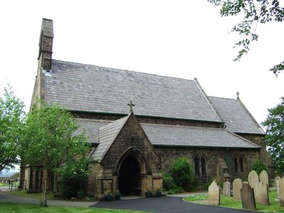
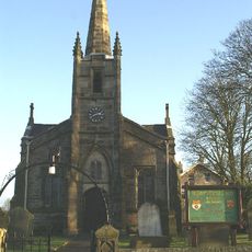
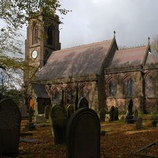
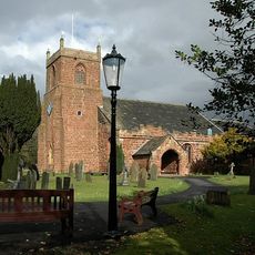
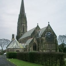
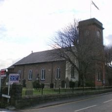
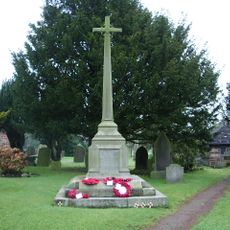
St James' Church, Wrightington Bar, Anglican church in Wrightington Bar, England

St James' Church is an Anglican place of worship built from sandstone rubble with a slate roof, featuring a four-bay nave, south aisle, porch, and chancel fitted with lancet windows. The interior contains a 1916 organ originally built by Jardine of Manchester, later modified to improve its performance.

Construction of this Grade II listed building began in 1854 under the design of architect Edward Graham Paley and was completed with consecration in 1857. The structure emerged during the height of the Gothic Revival movement in England.

The building serves as a spiritual center where the local community gathers for worship and religious events throughout the year. The space creates a gathering place for parish members who continue to use it for both faith-based services and community occasions.

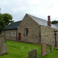
The building is situated on Church Lane and can be easily spotted from the road. Visitors should note that an adjacent theatre building hosts the St James Players group, which may mean additional activity in the area during performance times.

An adjacent theatre building houses the St James Players, a theatre group that stages regular productions and pantomimes throughout the year. This artistic use gives the site a cultural dimension beyond its primary religious function.

Location: Wrightington

Inception: 1857

Architects: Edward Graham Paley

Architectural style: Gothic Revival

Website: http://stjamesthegreat.net

GPS coordinates: 53.61690,-2.71750

Latest update: December 14, 2025 18:14

Photos
Around this place
Knightmare
United Kingdom

Knightmare

2.4 km
Heskin Hall
United Kingdom

Heskin Hall

2 km
Coppull Mill
United Kingdom

Coppull Mill

3.9 km
Mawdesley Hall
United Kingdom

Mawdesley Hall

3.2 km
St Peter's Church, Mawdesley
United Kingdom

St Peter's Church, Mawdesley

3.8 km
Mavis Mill
United Kingdom

Mavis Mill

3.8 km
Christ Church
United Kingdom

Christ Church

3.4 km
Church of St John the Divine, Coppull
United Kingdom

Church of St John the Divine, Coppull

3.5 km
Church of the Blessed Virgin Mary, Eccleston
United Kingdom

Church of the Blessed Virgin Mary, Eccleston

4.4 km
Christ Church
United Kingdom

Christ Church

3.8 km
Roman Catholic Church of Our Lady and All Saints
United Kingdom

Roman Catholic Church of Our Lady and All Saints

4.2 km
Church of St Joseph and Attached Presbytery
United Kingdom

Church of St Joseph and Attached Presbytery

2.9 km
Tunley Presbyterian Church And Sunday School
United Kingdom

Tunley Presbyterian Church And Sunday School

1.7 km
Chapel Lane Bridge (Number 39)  Leeds And Liverpool Canal Chapel Lane Bridge (Number 39)
United Kingdom

Chapel Lane Bridge (Number 39) Leeds And Liverpool Canal Chapel Lane Bridge (Number 39)

4.4 km
Red Herring (Former Office Block To Coppull Ring Mill)
United Kingdom

Red Herring (Former Office Block To Coppull Ring Mill)

3.9 km
Hesketh Arms Public House And Adjacent Mounting Block
United Kingdom

Hesketh Arms Public House And Adjacent Mounting Block

3.4 km
Milepost Outside Number 247
United Kingdom

Milepost Outside Number 247

4 km
Coppull Parish Church
United Kingdom

Coppull Parish Church

4.1 km
Leeds And Liverpool Canal Milestone Approximately 30 Metres South East Of Hand Lane Bridge
United Kingdom

Leeds And Liverpool Canal Milestone Approximately 30 Metres South East Of Hand Lane Bridge

4 km
Re-used Calvary Cross Slab, Churchyard Of The Church Of The Blessed Virgin Mary
United Kingdom

Re-used Calvary Cross Slab, Churchyard Of The Church Of The Blessed Virgin Mary

4.3 km
Leeds And Liverpool Canal Southern Lock At Appley Locks
United Kingdom

Leeds And Liverpool Canal Southern Lock At Appley Locks

4.1 km
Leeds And Liverpool Canal Bridge Number 40
United Kingdom

Leeds And Liverpool Canal Bridge Number 40

4.1 km
Milestone At Sd 534 133
United Kingdom

Milestone At Sd 534 133

863 m
Wrightington  Hall
United Kingdom

Wrightington Hall

3 km
Mawdesley War Memorial
United Kingdom

Mawdesley War Memorial

3.1 km
Leeds And Liverpool Canal Hand Lane Bridge (Number 41)
United Kingdom

Leeds And Liverpool Canal Hand Lane Bridge (Number 41)

4 km
Eccleston War Memorial, Lancashire
United Kingdom

Eccleston War Memorial, Lancashire

4.3 km
Milestone, The Hawthorns, jcn The Green
United Kingdom

Milestone, The Hawthorns, jcn The Green

3.9 km
Show the full map
Reviews

Visited this place? Tap the stars to rate it and share your experience / photos with the community! Try now! You can cancel it anytime.

« St James' Church, Wrightington Bar - Anglican church in Wrightington Bar, England » is provided by Around Us (aroundus.com). Images and texts are derived from Wikimedia project under a Creative Commons license. You are allowed to copy, distribute, and modify copies of this page, under the conditions set by the license, as long as this note is clearly visible.

Discover hidden gems everywhere you go!

From secret cafés to breathtaking viewpoints, skip the crowded tourist spots and find places that match your style. Our app makes it easy with voice search, smart filtering, route optimization, and insider tips from travelers worldwide. Download now for the complete mobile experience.

Around Us App Screenshot

A unique approach to discovering new places

Le Figaro

All the places worth exploring

France Info

A tailor-made excursion in just a few clicks

20 Minutes