Enable Location

We need your location to show you interesting places around you

Discover nearby places

Find interesting locations and hidden gems around you

Precise directions

Get accurate directions and distances to places

Your location is never shared with other users. It's only used when you tap the location button.

Cantlop Bridge

Log in to your account

Start exploring — it's free

Trusted by 62,559 travelers worldwide

Continue with Google
Continue with Apple
or

We will send you a code to connect

By continuing, you accept our Terms and Conditions and our Privacy Policy

Check your inbox

We've sent a pincode in your inbox. Please enter the code below.

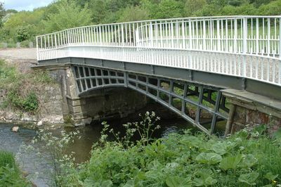
Cantlop Bridge, Cast iron road bridge in Berrington, England.

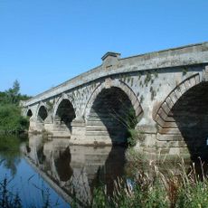
Cantlop Bridge is a cast-iron road bridge near Berrington in England that carries traffic across Cound Brook. It features four arched lattice ribs connected by five transverse cast-iron members supporting the metal deck plates.

Thomas Telford approved construction of this bridge in 1818 to replace an unsuccessful cast-iron structure built six years earlier. The new design corrected the failures of the previous attempt and provided a lasting solution for crossing the brook.

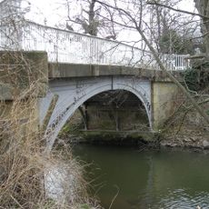
The structure shows how engineers in the early 19th century tried new materials while respecting local building traditions. The red and grey sandstone abutments reflect the region's construction methods of that time.

Access to the pedestrian bridge is easy via a layby near the modern concrete bridge that replaced it during the 1970s. This location makes it simple to stop and explore the historic structure without extensive detours.

This is the last surviving bridge in Shropshire approved by Telford, retaining its original cast-iron construction throughout. Its dressed sandstone abutments with chamfered edges show how early engineers blended new materials with traditional craftsmanship.

The community of curious travelers

AroundUs brings together thousands of curated places, local tips, and hidden gems, enriched daily by 60,000 contributors worldwide.

Start exploring
Location
GPS coordinates
52.65180,-2.71484
Latest update
December 14, 2025 13:00
Around this place
Condover Hall
United Kingdom

Condover Hall

2.3 km
Pitchford Hall
United Kingdom

Pitchford Hall

2.3 km
Acton Burnell Castle
United Kingdom

Acton Burnell Castle

4.7 km
Cronkhill
United Kingdom

Cronkhill

2.8 km
Cound Hall
United Kingdom

Cound Hall

4.4 km
St Eata's Church, Atcham
United Kingdom

St Eata's Church, Atcham

3.8 km
St Mary's Church, Acton Burnell
United Kingdom

St Mary's Church, Acton Burnell

4.6 km
St Peter's Church, Cound
United Kingdom

St Peter's Church, Cound

4.3 km
Acton Burnell Hall
United Kingdom

Acton Burnell Hall

4.6 km
The Mytton and Mermaid Hotel
United Kingdom

The Mytton and Mermaid Hotel

3.9 km
All Saints Church, Berrington
United Kingdom

All Saints Church, Berrington

1.4 km
Church of St Michael
United Kingdom

Church of St Michael

2.2 km
Church of St Mary and St Andrew
United Kingdom

Church of St Mary and St Andrew

2.3 km
Condover Hall gateway
United Kingdom

Condover Hall gateway

2.3 km
Cound War Memorial
United Kingdom

Cound War Memorial

4 km
Village Pump And Trough Approximately 10 Metres To South Of Numbers 66 And 72
United Kingdom

Village Pump And Trough Approximately 10 Metres To South Of Numbers 66 And 72

634 m
Atcham Bridge
United Kingdom

Atcham Bridge

3.8 km
Cound Arbour Bridge
United Kingdom

Cound Arbour Bridge

3.9 km
Entrance Screen And East And West Front Lodges To Attingham Park
United Kingdom

Entrance Screen And East And West Front Lodges To Attingham Park

3.9 km
Milestone Set In Front Garden Wall Of The Old Vicarage
United Kingdom

Milestone Set In Front Garden Wall Of The Old Vicarage

2.4 km
Milestone Approximately 40 Metres To The South Of Milestone Cottage
United Kingdom

Milestone Approximately 40 Metres To The South Of Milestone Cottage

703 m
Back Lodge
United Kingdom

Back Lodge

4.6 km
Milepost Approximately 50 Metres To North Of Number 39, Venusbank
United Kingdom

Milepost Approximately 50 Metres To North Of Number 39, Venusbank

3.7 km
Milestone Approximately 70 Metres To East Of North Lodge
United Kingdom

Milestone Approximately 70 Metres To East Of North Lodge

2 km
Milestone Approximately 10 Metres To North-West Of Emstrey Cottages
United Kingdom

Milestone Approximately 10 Metres To North-West Of Emstrey Cottages

4.1 km
The Warren
United Kingdom

The Warren

4.5 km
Milestone, Betton Abbots, S of Yewtree Cottages
United Kingdom

Milestone, Betton Abbots, S of Yewtree Cottages

2.4 km
Milestone, between B Abbots & Cantlop Bridge
United Kingdom

Milestone, between B Abbots & Cantlop Bridge

883 m
Show the full map
« Cantlop Bridge - Cast iron road bridge in Berrington, England » is provided by Around Us (aroundus.com). Images and texts are derived from Wikimedia project under a Creative Commons license. You are allowed to copy, distribute, and modify copies of this page, under the conditions set by the license, as long as this note is clearly visible.

Discover hidden gems everywhere you go!

From secret cafés to breathtaking viewpoints, skip the crowded tourist spots and find places that match your style. Our app makes it easy with voice search, smart filtering, route optimization, and insider tips from travelers worldwide. Download now for the complete mobile experience.

Around Us App Screenshot

A unique approach to discovering new places

Le Figaro

All the places worth exploring

France Info

A tailor-made excursion in just a few clicks

20 Minutes

Around Us
Travel Guide & Maps
Download

Send to your phone

QR Code
1

Open the camera app on your mobile.

2

Point at the QR code with your camera. A notification will appear.

3

Tap the notification to open the link.