Stanwick Camp

Log in to your account

AroundUs is a community-driven map of interesting places, built by curious explorers like you. It grows with every review, story, and photo you share.
Connect to save your favorite spots, contribute locations, and create personalized routes.
By continuing, you accept our Terms and Conditions and our Privacy Policy
Add to collection
Map
Suggest a change
Share

Stanwick Camp, Iron Age hillfort in Richmondshire, England

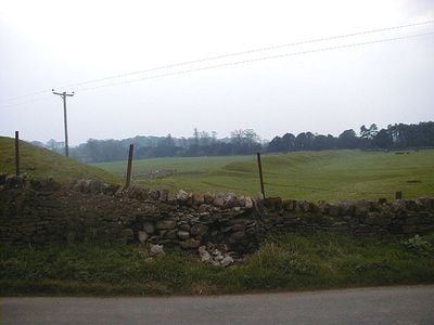
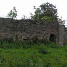
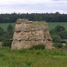
Stanwick Camp is a fortified settlement spread across broad countryside, defended by stone ramparts and deep ditches. The remains show multiple layers of construction from different periods of Iron Age occupation.

The settlement developed during the Iron Age and was expanded and rebuilt over several centuries. Archaeological work in the 1950s uncovered the different construction phases and how the place evolved.

The settlement was a major hub for the Brigantes tribe, where leaders engaged with Roman officials and traders. The surviving earthworks reflect how this place bridged two different worlds.

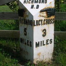
The site is freely accessible and visitors can walk across the ramparts and ditches, with the surrounding landscape being easy to navigate. Getting oriented in the terrain is helpful, as the layout is spread out and pathway markings are minimal.

Archaeologists uncovered a collection of about 140 metal objects here, including horse harness and ornaments from antiquity. These precious finds are now kept at the British Museum and reveal the wealth and trade connections of the settlement.

Location: Forcett

Website: https://english-heritage.org.uk/visit/places/stanwick-iron-age-fortifications

GPS coordinates: 54.49879,-1.71908

Latest update: December 9, 2025 18:44

Photos
Around this place
Show the full map
Forcett Hall
United Kingdom

Forcett Hall

1.4 km
Stanwick Park
United Kingdom

Stanwick Park

246 m
Piercebridge Roman Fort
United Kingdom

Piercebridge Roman Fort

5 km
St John the Baptist's Church, Stanwick
United Kingdom

St John the Baptist's Church, Stanwick

499 m
St James' Church, Melsonby
United Kingdom

St James' Church, Melsonby

3.6 km
Chapel Bridge Over Black Beck
United Kingdom

Chapel Bridge Over Black Beck

5 km
Piercebridge Roman Fort
United Kingdom

Piercebridge Roman Fort

5 km
Christ Church
United Kingdom

Christ Church

2.6 km
Church of St Cuthbert
United Kingdom

Church of St Cuthbert

1 km
Church of All Saints
United Kingdom

Church of All Saints

4.4 km
Church of St Mary
United Kingdom

Church of St Mary

5 km
Church of St Paul
United Kingdom

Church of St Paul

2 km
Ruins Of St Lawrence's Chapel
United Kingdom

Ruins Of St Lawrence's Chapel

5 km
Dovecote 100 metres north of St Lawrence's Chapel
United Kingdom

Dovecote 100 metres north of St Lawrence's Chapel

5.1 km
George Hotel
United Kingdom

George Hotel

4.9 km
Piercebridge Bridge
United Kingdom

Piercebridge Bridge

4.9 km
The Bridge House
United Kingdom

The Bridge House

4.9 km
Round barrow 340m east of Cliffe Hall known as Betty Watson's Hill
United Kingdom

Round barrow 340m east of Cliffe Hall known as Betty Watson's Hill

4.6 km
Medieval Chapel Ruins On Roman Foundations In Rear Garden Of Bath House, Tees View
United Kingdom

Medieval Chapel Ruins On Roman Foundations In Rear Garden Of Bath House, Tees View

4.9 km
Milepost 400 Metres North Of Junction With Pudding Hill Road
United Kingdom

Milepost 400 Metres North Of Junction With Pudding Hill Road

5.1 km
28, The Green
United Kingdom

28, The Green

5.1 km
Milestone, 110 Metres South Of Greystone Hall
United Kingdom

Milestone, 110 Metres South Of Greystone Hall

4.9 km
Aldbrough St John Packhorse Bridge
United Kingdom

Aldbrough St John Packhorse Bridge

1.9 km
Wall, Gate Piers, Overthrow And Lantern To West Of Church Of St Mary
United Kingdom

Wall, Gate Piers, Overthrow And Lantern To West Of Church Of St Mary

5 km
Milepost 400 Metres North Of Junction With Pudding Hill Road
United Kingdom

Milepost 400 Metres North Of Junction With Pudding Hill Road

5.1 km
Dovecote
United Kingdom

Dovecote

1.3 km
Milestone, NW of lane to Hartforth
United Kingdom

Milestone, NW of lane to Hartforth

3.9 km
Milestone, S end of Melsonby village
United Kingdom

Milestone, S end of Melsonby village

3.9 km
Show the full map
Reviews

Visited this place? Tap the stars to rate it and share your experience / photos with the community! Try now! You can cancel it anytime.

« Stanwick Camp - Iron Age hillfort in Richmondshire, England » is provided by Around Us (aroundus.com). Images and texts are derived from Wikimedia project under a Creative Commons license. You are allowed to copy, distribute, and modify copies of this page, under the conditions set by the license, as long as this note is clearly visible.

Discover hidden gems everywhere you go!

From secret cafés to breathtaking viewpoints, skip the crowded tourist spots and find places that match your style. Our app makes it easy with voice search, smart filtering, route optimization, and insider tips from travelers worldwide. Download now for the complete mobile experience.

Around Us App Screenshot

A unique approach to discovering new places

Le Figaro

All the places worth exploring

France Info

A tailor-made excursion in just a few clicks

20 Minutes