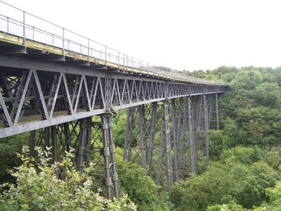
Meldon Viaduct, Railway viaduct in Okehampton Hamlets, England.
Meldon Viaduct is a railway bridge made of wrought and cast iron that spans the West Okement River with six curved arch sections. The structure rests on iron lattice trestles that support the entire weight of the bridge and trains that cross it.
Construction of this railway bridge finished in 1874 to carry single-track trains across the valley. By 1879 the bridge was widened to support two tracks as railway traffic increased.
The structure represents Victorian engineering excellence through its intricate metalwork and stands as one of two remaining railway bridges with wrought iron lattice piers in Britain.
This bridge is accessible via the Granite Way, a cycle path and walking trail that follows the old railway line through the area. The route is free to use and well-maintained for both walkers and cyclists exploring the Dartmoor region.
When the bridge was widened in 1879, rail-mounted cranes were used to lift and position 21-ton iron trusses one section at a time. The speed of the work was remarkable, with each heavy component placed into position in about two and a half hours.
Location: Okehampton Hamlets
Official opening: 1874
Made from material: wrought iron, cast iron
GPS coordinates: 50.71300,-4.03404
Latest update: December 8, 2025 20:03
Okehampton Castle
2.6 km
Yes Tor
2.7 km
Meldon Quarry
660 m
Museum of Dartmoor Life
3.6 km
Town Hall
3.6 km
Church of St Thomas of Canterbury
3.6 km
Church of All Saints
3.2 km
Fice's Well And Cross
3.1 km
White Hart Hotel
3.6 km
Churchyard Cross Immediately West Of All Saints Church
3.2 km
Chimney About 50 Metres West North West Of Town Mill
3.6 km
Lloyds Bank
3.6 km
Town Mill
3.7 km
Meldon Reservoir
1.1 km
Chalet Treloar
3.4 km
5, West Street
3.6 km
Brock's Almshouses
3.3 km
Wayside Stone Approximately 100 Metres To North North West Of Church Of St Thomas
3.6 km
Wayside cross in the garden hedge of Southcott Cottage, at a crossroads called Southcott Cross
2.9 km
Stone cross adjoining Fitz or Fice's Well
3 km
Darley House Including Front Garden Area Railings And Piers
3.5 km
26-38, Station Road
3.4 km
Footbridge About 30 Metres West Of Chimney At Town Mill
3.6 km
Sourton Down Cross
2.1 km
1 and 3, West Street
3.6 km
Round cairn and shelter 140m north west of Yes Tor summit
2.6 km
Guidestone, Sourton Common
3.5 km
Milestone, 150m W of jct with A386 (before turn to A30)
2.5 kmVisited this place? Tap the stars to rate it and share your experience / photos with the community! Try now! You can cancel it anytime.
Discover hidden gems everywhere you go!
From secret cafés to breathtaking viewpoints, skip the crowded tourist spots and find places that match your style. Our app makes it easy with voice search, smart filtering, route optimization, and insider tips from travelers worldwide. Download now for the complete mobile experience.
A unique approach to discovering new places❞
— Le Figaro
All the places worth exploring❞
— France Info
A tailor-made excursion in just a few clicks❞
— 20 Minutes