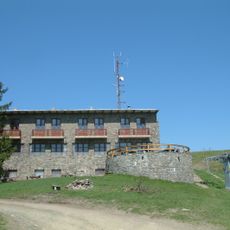
Magos-fa, Mountain summit in Pest County, Hungary.
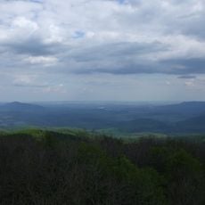
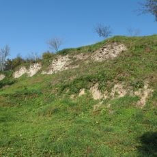
Magos-fa is a mountain in Pest County standing at approximately 900 meters high, with varied vegetation covering its slopes. The landscape features diverse geological formations that shape the mountainside.
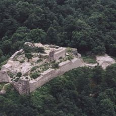
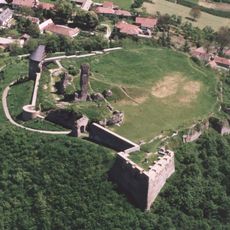
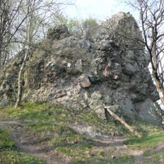
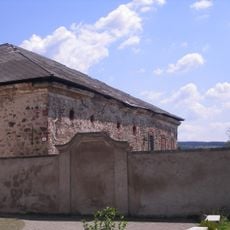
The summit holds the remains of an Iron Age fortress, indicating sustained human settlement at this location. Archaeological discoveries of pottery from the Late Bronze Age confirm even earlier occupation of the site.
The mountain is known locally as 'Tátralótó', a name that reflects the sweeping views available from the summit on clear winter days. From this vantage point, the distant Tatra Mountains become visible along the horizon.
The hiking trails to the summit are marked with green blazes and can be accessed from the village of Kemence or from the direction of Csóványos mountain. These established routes provide clear guidance throughout the ascent.
The fortress ruins at the peak spread across a substantial area and still show the outlines of ancient structures. Some sections of the defensive walls have survived with heights reaching up to one meter.
Location: Pest County
Elevation above the sea: 916 m
GPS coordinates: 47.95779,18.93858
Latest update: December 14, 2025 18:06
Drégely Castle
9.8 km
Castle of Nógrád
9.7 km
Csóványos
1.2 km
Márianosztra Strict and Medium Regime Prison
11.2 km
Nagy-Hideg-hegy
2.6 km
Castle of Salgó, Perőcsény
4.5 km
Saint Stephen of Hungary Church
9.6 km
Kálmán Mikszáth Memorial House
15 km
Damásd Castle
15.1 km
Csóványos observation tower
1.2 km
Our Lady of Hungary Basilica
11.3 km
Nagy-hideg-hegyi turistaház
2.7 km
Poiplie
13.4 km
Börzsöny Múzeum
16.6 km
Sávoly Bridge
16.3 km
Gymnázium (Šahy, Mládežnícka 22)
13.4 km
Synagogue in Šahy
12.7 km
Saint Nicholas Church in Nagybörzsöny
8.9 km
Ipeľská niva
13.6 km
Pomník Červenej armády
12.5 km
Church of St. Imrich
16.3 km
Mariánsky stĺp, socha
12.5 km
Pieta
14.5 km
Pieta
14.5 km
Kostol Nanebovzatia P. Márie, sýpka
12.5 km
Town hall of Šahy
12.5 km
Mariánsky stĺp, stĺp s podstavcom
12.5 km
Radnica, býv. župný dom, tabuľa pamätná
12.5 kmVisited this place? Tap the stars to rate it and share your experience / photos with the community! Try now! You can cancel it anytime.
Discover hidden gems everywhere you go!
From secret cafés to breathtaking viewpoints, skip the crowded tourist spots and find places that match your style. Our app makes it easy with voice search, smart filtering, route optimization, and insider tips from travelers worldwide. Download now for the complete mobile experience.
A unique approach to discovering new places❞
— Le Figaro
All the places worth exploring❞
— France Info
A tailor-made excursion in just a few clicks❞
— 20 Minutes