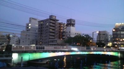
両国橋, Steel girder bridge in Tokyo, Japan
Ryogoku Bridge is a steel girder bridge crossing the Sumida River and connecting Central and Sumida districts. The structure spans about 164 meters with three continuous steel plate girder sections, measuring 24 meters wide.
The original bridge was built in 1659 and named Ohashi, marking the boundary between Musashi and Shimosa provinces. The name Ryogoku, meaning two provinces, was later adopted to reflect this cross-boundary significance.
The bridge area served as a gathering place for fireworks displays during the Edo period, starting in 1732 as part of water deity celebrations. Locals and visitors still recognize this connection to traditional summer festivities that shaped the neighborhood's character.
The bridge provides easy access to multiple train lines including the Asakusa and Sobu lines. Pedestrians find wide walkways and clear views of the river and surrounding neighborhoods from both sides.
The bridge's location was crucial for Edo's eastward expansion across the Sumida River, fundamentally reshaping the city's urban development. This made the site a pivotal turning point in Tokyo's growth as a metropolis.
The community of curious travelers
AroundUs brings together thousands of curated places, local tips, and hidden gems, enriched daily by 60,000 contributors worldwide.