Enable Location

We need your location to show you interesting places around you

Discover nearby places

Find interesting locations and hidden gems around you

Precise directions

Get accurate directions and distances to places

Your location is never shared with other users. It's only used when you tap the location button.

Boundary marker St. Martin

Log in to your account

Start exploring — it's free

Trusted by 62,624 travelers worldwide

Continue with Google
Continue with Apple
or

We will send you a code to connect

By continuing, you accept our Terms and Conditions and our Privacy Policy

Check your inbox

We've sent a pincode in your inbox. Please enter the code below.

Boundary marker St. Martin

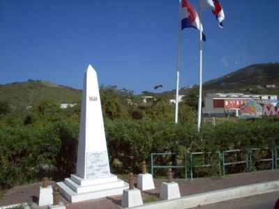
Boundary marker St. Martin, monument op de grens tussen Frans en Nederlands Sint Maarten

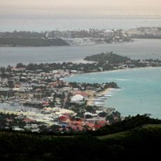
The boundary marker St. Martin is an obelisk on Sint Maarten that marks the historical dividing line between two parts of the island. The monument serves as an important reference point where visitors can see the actual boundary that separates different administrative areas on the island.

The boundary marker was established to indicate the division of Sint Maarten island between different administrative areas. The monument reflects the island's complex history of territorial organization and political arrangements.

The obelisk sits in an accessible location on the island where visitors can reach it without difficulty. The best time to visit is early morning or late afternoon when the sunlight is more favorable for viewing and photography.

The community of curious travelers

AroundUs brings together thousands of curated places, local tips, and hidden gems, enriched daily by 60,000 contributors worldwide.

Start exploring
Inception
1948
GPS coordinates
18.05588,-63.04048
Latest update
December 6, 2025 17:47
Saint-Martin attractions: beaches, forts, nature

Saint-Martin is a Caribbean island divided between France and the Netherlands. The coastline features white sand beaches such as Orient Bay, Maho Beach, and Baie Rouge, while smaller islands like Pinel and Tintamarre sit just offshore. The interior rises to Pic Paradis, which stands 424 meters...

« Boundary marker St. Martin - monument op de grens tussen Frans en Nederlands Sint Maarten » is provided by Around Us (aroundus.com). Images and texts are derived from Wikimedia project under a Creative Commons license. You are allowed to copy, distribute, and modify copies of this page, under the conditions set by the license, as long as this note is clearly visible.

Discover hidden gems everywhere you go!

From secret cafés to breathtaking viewpoints, skip the crowded tourist spots and find places that match your style. Our app makes it easy with voice search, smart filtering, route optimization, and insider tips from travelers worldwide. Download now for the complete mobile experience.

Around Us App Screenshot

A unique approach to discovering new places

Le Figaro

All the places worth exploring

France Info

A tailor-made excursion in just a few clicks

20 Minutes

Around Us
Travel Guide & Maps
Download

Send to your phone

QR Code
1

Open the camera app on your mobile.

2

Point at the QR code with your camera. A notification will appear.

3

Tap the notification to open the link.