Enable Location

We need your location to show you interesting places around you

Discover nearby places

Find interesting locations and hidden gems around you

Precise directions

Get accurate directions and distances to places

Your location is never shared with other users. It's only used when you tap the location button.

Fort Mansfield

Log in to your account

Start exploring — it's free

Trusted by 61,454 travelers worldwide

Continue with Google
Continue with Apple
or

We will send you a code to connect

By continuing, you accept our Terms and Conditions and our Privacy Policy

Check your inbox

We've sent a pincode in your inbox. Please enter the code below.

Fort Mansfield

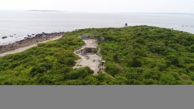
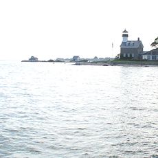
Fort Mansfield, Coastal fortification in Watch Hill, Rhode Island, United States.

Description

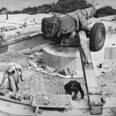
Fort Mansfield is a coastal fortification in Watch Hill with concrete gun batteries, underground magazines, and defensive structures built into the rocky terrain at Napatree Point. The installation displays early 1900s military construction techniques through its various shelters and weapon emplacements positioned to overlook the shoreline.

History

The fort was built in 1901 by the US Army as part of a coastal defense system for Long Island Sound against potential naval attacks. After World War One, the fortification lost strategic importance and was gradually abandoned.

Culture

The fort exemplifies the military engineering standards of the early 1900s through its strategic placement and architectural design choices for coastal protection.

Practical

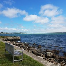
The fort is reached through Napatree Point Conservation Area by following a sandy beach trail that extends roughly one and a half kilometers. The walk is relatively level but the sandy ground can be tiring, especially on warm days.

Did you know?

Three separate concrete gun emplacements named Battery Wooster, Battery Crawford, and Battery Connell formed the main defensive positions of the installation. These individual batteries were spaced apart to prevent destruction from a single hit.

Inception
1901
GPS coordinates
41.30660,-71.88512
Latest update
December 10, 2025 20:06

AroundUs brings together thousands of curated places, local tips, and hidden gems, enriched daily by 60,000 contributors worldwide. Discover all places nearby (United States of America).

Around this place
Misquamicut State Beach
United States of America

Misquamicut State Beach

7.1 km
Mystic River Bascule Bridge
United States of America

Mystic River Bascule Bridge

8.8 km
Flying Horse Carousel
United States of America

Flying Horse Carousel

2.2 km
Mystic Seaport Museum
United States of America

Mystic Seaport Museum

9 km
Emma C. Berry
United States of America

Emma C. Berry

9 km
L. A. Dunton
United States of America

L. A. Dunton

8.9 km
Stonington Harbor Light
United States of America

Stonington Harbor Light

3 km
Latimer Reef Light
United States of America

Latimer Reef Light

4 km
Capt. Nathaniel B. Palmer House
United States of America

Capt. Nathaniel B. Palmer House

4.5 km
Watch Hill Light
United States of America

Watch Hill Light

2.3 km
Mystic Bridge Historic District
United States of America

Mystic Bridge Historic District

8.7 km
Mystic River Railroad Bridge
United States of America

Mystic River Railroad Bridge

8.5 km
James Merrill House
United States of America

James Merrill House

3.5 km
Morgan Point Light
United States of America

Morgan Point Light

8.6 km
Pequotsepos Manor
United States of America

Pequotsepos Manor

8.2 km
Mechanic Street Historic District
United States of America

Mechanic Street Historic District

8.6 km
Mystic Museum of Art
United States of America

Mystic Museum of Art

8.8 km
Holiday House
United States of America

Holiday House

2.5 km
Babcock-Smith House
United States of America

Babcock-Smith House

9 km
Robert Stanton House
United States of America

Robert Stanton House

4.2 km
Rossie Velvet Mill Historic District
United States of America

Rossie Velvet Mill Historic District

8.3 km
Noank Historic District
United States of America

Noank Historic District

8.9 km
Main Street Historic District
United States of America

Main Street Historic District

8.7 km
John Palmer House
United States of America

John Palmer House

4.5 km
Oak's Inn Military Reservation
United States of America

Oak's Inn Military Reservation

7.3 km
Perry Homestead Historic District
United States of America

Perry Homestead Historic District

8.3 km
Lewis-Card-Perry House
United States of America

Lewis-Card-Perry House

7.3 km
The Stonington Lighthouse Museum
United States of America

The Stonington Lighthouse Museum

3 km
Show the full map
« Fort Mansfield - Coastal fortification in Watch Hill, Rhode Island, United States » is provided by Around Us (aroundus.com). Images and texts are derived from Wikimedia project under a Creative Commons license. You are allowed to copy, distribute, and modify copies of this page, under the conditions set by the license, as long as this note is clearly visible.

Discover hidden gems everywhere you go!

From secret cafés to breathtaking viewpoints, skip the crowded tourist spots and find places that match your style. Our app makes it easy with voice search, smart filtering, route optimization, and insider tips from travelers worldwide. Download now for the complete mobile experience.

Around Us App Screenshot

A unique approach to discovering new places

Le Figaro

All the places worth exploring

France Info

A tailor-made excursion in just a few clicks

20 Minutes

Around Us
Travel Guide & Maps
Download

Send to your phone

QR Code
1

Open the camera app on your mobile.

2

Point at the QR code with your camera. A notification will appear.

3

Tap the notification to open the link.