Enable Location

We need your location to show you interesting places around you

Discover nearby places

Find interesting locations and hidden gems around you

Precise directions

Get accurate directions and distances to places

Your location is never shared with other users. It's only used when you tap the location button.

Flambeau River State Forest

Log in to your account

Start exploring — it's free

Trusted by 62,076 travelers worldwide

Continue with Google
Continue with Apple
or

We will send you a code to connect

By continuing, you accept our Terms and Conditions and our Privacy Policy

Check your inbox

We've sent a pincode in your inbox. Please enter the code below.

Flambeau River State Forest

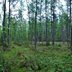
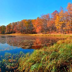
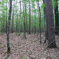
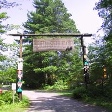
Flambeau River State Forest, State forest and National Natural Landmark in Sawyer County, Wisconsin

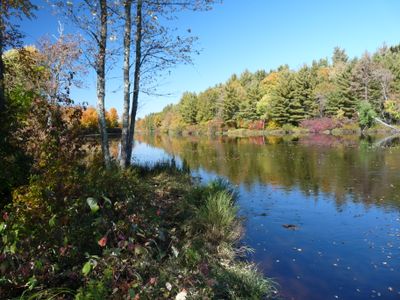
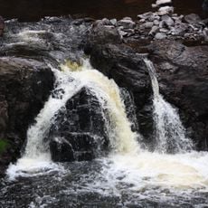
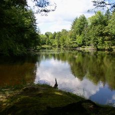
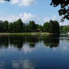
Flambeau River State Forest is a large forest area in northern Wisconsin shaped by two river branches that flow through it. The land offers trails for walking, designated camping spots, and water access points for paddling.

Native Americans used this landscape as a vital travel corridor long before settlers arrived and began large-scale logging in the 1800s. The forest gradually regrew after the logging era ended, shaping what visitors see today.

The river has long shaped how people moved through and lived in this region, and you can sense that connection when paddling or walking through the forest. Local communities still relate to this place as part of their identity and history.

The forest is accessible when open during the season, and it helps to check conditions beforehand since weather affects trail and water situations. Bring sturdy footwear and plan for muddy conditions, especially after rain.

The two main river branches meet within the forest and create one continuous water corridor through the landscape. This junction makes the place special for paddlers who want to explore different routes from a single location.

The community of curious travelers

AroundUs brings together thousands of curated places, local tips, and hidden gems, enriched daily by 60,000 contributors worldwide.

Start exploring
Location
GPS coordinates
45.74830,-90.76420
Latest update
December 9, 2025 12:21
Around this place
Copper Falls State Park
United States of America

Copper Falls State Park

70.5 km
National Fresh Water Fishing Hall of Fame
United States of America

National Fresh Water Fishing Hall of Fame

62.5 km
Brunet Island State Park
United States of America

Brunet Island State Park

70.7 km
Lidice Memorial
United States of America

Lidice Memorial

28.4 km
United States of America

Powell Marsh Wildlife Area

77.3 km
Wisconsin Concrete Park
United States of America

Wisconsin Concrete Park

30.4 km
Cornell Pulpwood Stacker
United States of America

Cornell Pulpwood Stacker

70.8 km
Lake Hayward
United States of America

Lake Hayward

61.9 km
Twin Lakes Bog State Natural Area
United States of America

Twin Lakes Bog State Natural Area

58.7 km
Park Theater
United States of America

Park Theater

62.7 km
Flambeau Mission Church
United States of America

Flambeau Mission Church

60.1 km
ZCBJ Hall
United States of America

ZCBJ Hall

80.5 km
Fifield Fire Lookout Tower
United States of America

Fifield Fire Lookout Tower

37.5 km
Jump River Town Hall
United States of America

Jump River Town Hall

44.2 km
Mellen City Hall
United States of America

Mellen City Hall

64.9 km
Fifield Town Hall
United States of America

Fifield Town Hall

30.2 km
Marion Park Pavilion
United States of America

Marion Park Pavilion

45 km
Medford Free Public Library
United States of America

Medford Free Public Library

75.9 km
Forest Lodge Library
United States of America

Forest Lodge Library

65.4 km
Taylor County Courthouse
United States of America

Taylor County Courthouse

75.6 km
Chippewa Moraine Lakes State Natural Area
United States of America

Chippewa Moraine Lakes State Natural Area

74.8 km
Freshwater Fishing Hall of Fame
United States of America

Freshwater Fishing Hall of Fame

62.5 km
Glidden State Bank
United States of America

Glidden State Bank

45.7 km
Finnerud Forest Scientific Area
United States of America

Finnerud Forest Scientific Area

79.8 km
Rice Lake station
United States of America

Rice Lake station

80.5 km
North Star Camp For Boys
United States of America

North Star Camp For Boys

52.5 km
Mondeaux Dam Recreation Area
United States of America

Mondeaux Dam Recreation Area

52.2 km
Smith Rapids Covered Bridge
United States of America

Smith Rapids Covered Bridge

49.4 km
Show the full map
« Flambeau River State Forest - State forest and National Natural Landmark in Sawyer County, Wisconsin » is provided by Around Us (aroundus.com). Images and texts are derived from Wikimedia project under a Creative Commons license. You are allowed to copy, distribute, and modify copies of this page, under the conditions set by the license, as long as this note is clearly visible.

Discover hidden gems everywhere you go!

From secret cafés to breathtaking viewpoints, skip the crowded tourist spots and find places that match your style. Our app makes it easy with voice search, smart filtering, route optimization, and insider tips from travelers worldwide. Download now for the complete mobile experience.

Around Us App Screenshot

A unique approach to discovering new places

Le Figaro

All the places worth exploring

France Info

A tailor-made excursion in just a few clicks

20 Minutes

Around Us
Travel Guide & Maps
Download

Send to your phone

QR Code
1

Open the camera app on your mobile.

2

Point at the QR code with your camera. A notification will appear.

3

Tap the notification to open the link.