Enable Location

We need your location to show you interesting places around you

Discover nearby places

Find interesting locations and hidden gems around you

Precise directions

Get accurate directions and distances to places

Your location is never shared with other users. It's only used when you tap the location button.

Gunstock Mountain

Log in to your account

Start exploring — it's free

Trusted by 65,032 travelers worldwide

Continue with Google
Continue with Apple
or

We will send you a code to connect

By continuing, you accept our Terms and Conditions and our Privacy Policy

Check your inbox

We've sent a pincode in your inbox. Please enter the code below.

Gunstock Mountain
Discussion Reviews 1 Photos
4.4k Popularity

Gunstock Mountain, Mountain summit in Gilford, New Hampshire, US.

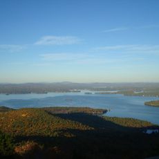
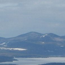
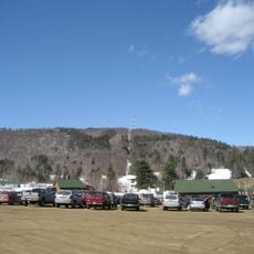
Gunstock Mountain is a mountain and recreation area in the Belknap Mountains of New Hampshire, rising to about 2,240 feet (683 meters) and operated as a ski area in winter with dozens of trails spread across the slopes. The terrain covers a range of slope angles connected by several lifts, and on clear days the view reaches Lake Winnipesaukee and the hills beyond.

The recreation area was built in 1937 by the Works Progress Administration, a federal program created to provide jobs during the Depression. Shortly after opening, it became home to the first chairlift installed in the eastern United States, a development that shaped how ski areas across the region would later be built.

The trails carry names like Pistol, Musket, and Trigger, drawn from the world of firearms and reflecting the area's old craft traditions. Visitors reading the signs on the slopes get a small but tangible connection to the local heritage without needing to leave the trail.

Trails are marked by difficulty level, so both beginners and more experienced visitors can find a route that suits them without much guesswork. In winter, it is worth checking conditions before heading out, since the slopes and lifts depend heavily on snow coverage.

A mountain coaster runs along the slopes year-round, letting visitors ride downhill on a fixed track even when there is no snow on the ground. In summer, aerial obstacle courses and ziplines draw a very different crowd than the one that comes for skiing, making the mountain a two-season destination with almost no overlap.

The community of curious travelers

AroundUs brings together thousands of curated places, local tips, and hidden gems, enriched daily by 60,000 contributors worldwide.

Start exploring
Location
Elevation above the sea
683 m
GPS coordinates
43.52563,-71.37840
Latest update
March 3, 2026 08:10
Around this place
Funspot
United States of America

Funspot

12.6 km
United States of America

Mount Major

7.5 km
Kimball Castle
United States of America

Kimball Castle

6.5 km
United States of America

Belknap Mountain

1.1 km
United States of America

Mount Rowe

2.2 km
Endicott Rock
United States of America

Endicott Rock

10.8 km
Ellacoya State Park
United States of America

Ellacoya State Park

5.7 km
Ahern State Park
United States of America

Ahern State Park

10.4 km
Libby Museum
United States of America

Libby Museum

13.8 km
Laconia District Court
United States of America

Laconia District Court

7.4 km
Windermere
United States of America

Windermere

12.4 km
Benjamin Rowe House
United States of America

Benjamin Rowe House

2.8 km
Gale Memorial Library
United States of America

Gale Memorial Library

7.5 km
District No. 9 Schoolhouse
United States of America

District No. 9 Schoolhouse

1.6 km
Smith Meeting House
United States of America

Smith Meeting House

12.3 km
Gilmanton Ironworks Library
United States of America

Gilmanton Ironworks Library

13.7 km
First Freewill Baptist Church
United States of America

First Freewill Baptist Church

14.4 km
Colonial Theatre Complex
United States of America

Colonial Theatre Complex

7.4 km
Belmont Public Library
United States of America

Belmont Public Library

12.4 km
Ossian Wilbur Goss Reading Room
United States of America

Ossian Wilbur Goss Reading Room

7.6 km
New Hampshire Veterans' Association Historic District
United States of America

New Hampshire Veterans' Association Historic District

11.1 km
Brewster Memorial Hall
United States of America

Brewster Memorial Hall

15.1 km
Federal Building
United States of America

Federal Building

7.5 km
John W. Busiel House
United States of America

John W. Busiel House

7.5 km
Bay Meeting House and Vestry
United States of America

Bay Meeting House and Vestry

12.8 km
American Classic Arcade Museum
United States of America

American Classic Arcade Museum

12.6 km
Paugus Bay Bridge
United States of America

Paugus Bay Bridge

10.7 km
Weirs Channel Bridge
United States of America

Weirs Channel Bridge

10.7 km
Show the full map
Reviews
Share your experience

No review yet

Discussions
Start a discussion...

No discussion yet

« Gunstock Mountain - Mountain summit in Gilford, New Hampshire, US » is provided by Around Us (aroundus.com). Images and texts are derived from Wikimedia project under a Creative Commons license. You are allowed to copy, distribute, and modify copies of this page, under the conditions set by the license, as long as this note is clearly visible.

Discover hidden gems everywhere you go!

From secret cafés to breathtaking viewpoints, skip the crowded tourist spots and find places that match your style. Our app makes it easy with voice search, smart filtering, route optimization, and insider tips from travelers worldwide. Download now for the complete mobile experience.

Around Us App Screenshot

A unique approach to discovering new places

Le Figaro

All the places worth exploring

France Info

A tailor-made excursion in just a few clicks

20 Minutes

Around Us
Travel Guide & Maps
Download

Send to your phone

QR Code
1

Open the camera app on your mobile.

2

Point at the QR code with your camera. A notification will appear.

3

Tap the notification to open the link.