Enable Location

We need your location to show you interesting places around you

Discover nearby places

Find interesting locations and hidden gems around you

Precise directions

Get accurate directions and distances to places

Your location is never shared with other users. It's only used when you tap the location button.

Hibriten Mountain

Log in to your account

Start exploring — it's free

Trusted by 62,490 travelers worldwide

Continue with Google
Continue with Apple
or

We will send you a code to connect

By continuing, you accept our Terms and Conditions and our Privacy Policy

Check your inbox

We've sent a pincode in your inbox. Please enter the code below.

Hibriten Mountain

Hibriten Mountain, mountain in United States of America

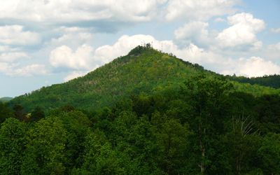
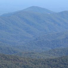
Hibriten Mountain is a peak near Lenoir, North Carolina, rising close to 2000 feet above the surrounding land. The trails wind through forested slopes with rocky outcrops at the summit and views across Caldwell County and the Brushy Mountains.

A fire tower with about 100 steps was built on the summit in 1927 to watch for forest fires across the surrounding counties. A hang gliding ramp was added in 1982, establishing the mountain as a launching point for aerial sports.

The mountain is a landmark for the town of Lenoir, with a name inspired by Brighton in England. The Christmas star and Easter cross lit from the summit are part of the local identity and are cherished by both residents and visitors.

The main trail is about 2.5 miles of gravel and easy walking suitable for most ages, starting from a parking lot at the end of Hibriten Mountain Road. Bring water, wear sturdy shoes, apply sunscreen, and plan your visit during daylight hours, as the access roads are private property with restricted hours.

The name comes from someone who admired the beauty of Brighton in England and created a name blending 'high' with 'Brighton' to match the landscape. The Easter cross and Christmas star lit from the summit have been regional landmarks for decades, visible for miles around.

The community of curious travelers

AroundUs brings together thousands of curated places, local tips, and hidden gems, enriched daily by 60,000 contributors worldwide.

Start exploring
Location
Opening Hours
sunrise-sunset
GPS coordinates
35.90694,-81.48944
Latest update
February 7, 2026 11:40
Around this place
Fort Defiance
United States of America

Fort Defiance

11.9 km
Edgar Allan Poe House
United States of America

Edgar Allan Poe House

4.8 km
Waldensian Presbyterian Church
United States of America

Waldensian Presbyterian Church

19.4 km
Tuttle Educational State Forest
United States of America

Tuttle Educational State Forest

14.6 km
Adams Mountain
United States of America

Adams Mountain

21.4 km
Lenoir High School
United States of America

Lenoir High School

4.9 km
Claremont High School Historic District
United States of America

Claremont High School Historic District

23.1 km
Nuckolls-Jefferies House
United States of America

Nuckolls-Jefferies House

15.7 km
Shuford House
United States of America

Shuford House

23.3 km
Propst House
United States of America

Propst House

21.3 km
Mulberry Chapel Methodist Church
United States of America

Mulberry Chapel Methodist Church

15.1 km
Markham-Albertson-Stinson Cottage
United States of America

Markham-Albertson-Stinson Cottage

13.3 km
Clover Hill
United States of America

Clover Hill

10.4 km
Oakwood Historic District
United States of America

Oakwood Historic District

22.9 km
Lenoir Downtown Historic District
United States of America

Lenoir Downtown Historic District

4.5 km
Green Park Historic District
United States of America

Green Park Historic District

4.5 km
Houck's Chapel
United States of America

Houck's Chapel

21.1 km
Dr. Glenn R. Frye House
United States of America

Dr. Glenn R. Frye House

23.1 km
Clement Geitner House
United States of America

Clement Geitner House

23.4 km
Jean-Pierre Auguste Dalmas House
United States of America

Jean-Pierre Auguste Dalmas House

17.9 km
Mary's Grove
United States of America

Mary's Grove

6.9 km
Lee & Helen George House
United States of America

Lee & Helen George House

22.7 km
Riverside
United States of America

Riverside

17.4 km
Mariah's Chapel
United States of America

Mariah's Chapel

17.8 km
John Alfred Moretz House
United States of America

John Alfred Moretz House

20.9 km
Caldwell County Courthouse
United States of America

Caldwell County Courthouse

4.7 km
Sloan-Throneburg Farm
United States of America

Sloan-Throneburg Farm

16.7 km
Gigi's Parlor
United States of America

Gigi's Parlor

23.3 km
Show the full map
« Hibriten Mountain - mountain in United States of America » is provided by Around Us (aroundus.com). Images and texts are derived from Wikimedia project under a Creative Commons license. You are allowed to copy, distribute, and modify copies of this page, under the conditions set by the license, as long as this note is clearly visible.

Discover hidden gems everywhere you go!

From secret cafés to breathtaking viewpoints, skip the crowded tourist spots and find places that match your style. Our app makes it easy with voice search, smart filtering, route optimization, and insider tips from travelers worldwide. Download now for the complete mobile experience.

Around Us App Screenshot

A unique approach to discovering new places

Le Figaro

All the places worth exploring

France Info

A tailor-made excursion in just a few clicks

20 Minutes

Around Us
Travel Guide & Maps
Download

Send to your phone

QR Code
1

Open the camera app on your mobile.

2

Point at the QR code with your camera. A notification will appear.

3

Tap the notification to open the link.