J. Clark Salyer National Wildlife Refuge

Log in to your account

AroundUs is a community-driven map of interesting places, built by curious explorers like you. It grows with every review, story, and photo you share.
Connect to save your favorite spots, contribute locations, and create personalized routes.
Continue with Google
Continue with Apple
Continue with X
Continue with Facebook
Continue with email
By continuing, you accept our Terms and Conditions and our Privacy Policy
Create an account

J. Clark Salyer National Wildlife Refuge

Add to collection
Map
Suggest a change
Share

J. Clark Salyer National Wildlife Refuge, National Wildlife Refuge along Souris River, North Dakota.

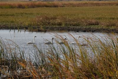
J. Clark Salyer National Wildlife Refuge is a protected area along the Souris River featuring wetlands, grasslands, and river valley habitats spread across a large area. Multiple water control dikes divide sections of the refuge to manage water levels and create diverse environments for wildlife.

The refuge was founded in 1935 as Lower Souris National Wildlife Refuge and renamed in 1967 to honor John Clark Salyer II. This change reflected growing recognition of his contributions to wildlife conservation efforts.

Indigenous peoples including the Arikara, Assiniboine, Cheyenne, Hidatsa, Lakota, and Mandan inhabited this region for centuries before European arrival. Their presence shaped the land and remains part of the area's identity today.

The visitor center and headquarters are located near Upham and accessible from U.S. Highway 2 via State Highway 14. Plan visits during daylight hours and use marked trails and observation areas to explore the different habitats safely.

The refuge serves as a critical stopping point for hundreds of bird species during their seasonal migrations between northern and southern regions. This role makes it an important destination for anyone interested in observing bird movements and studying migration patterns.

Location: North Dakota

Inception: 1935

Website: https://fws.gov/refuge/J_Clark_Salyer

GPS coordinates: 48.61670,-100.70000

Latest update: December 14, 2025 12:23

Photos
Around this place
740th Missile Squadron
United States of America

740th Missile Squadron

53.4 km
741st Missile Squadron
United States of America

741st Missile Squadron

53.4 km
Dakota Territory Air Museum
United States of America

Dakota Territory Air Museum

58 km
742d Missile Squadron
United States of America

742d Missile Squadron

53.4 km
Taube Museum of Art
United States of America

Taube Museum of Art

60.9 km
State Bank of Antler
United States of America

State Bank of Antler

58.1 km
Westland Oil Filling Station
United States of America

Westland Oil Filling Station

60.5 km
Old Main (Minot State University)
United States of America

Old Main (Minot State University)

60.6 km
McHenry County Courthouse
United States of America

McHenry County Courthouse

37.5 km
Westgaard Bridge
United States of America

Westgaard Bridge

56.5 km
Renville County Courthouse
United States of America

Renville County Courthouse

61.7 km
Rugby Post Office
United States of America

Rugby Post Office

58.9 km
Old Main
United States of America

Old Main

30.8 km
Eastwood Park Bridge
United States of America

Eastwood Park Bridge

60.5 km
Granville State Bank
United States of America

Granville State Bank

40.1 km
Minot Carnegie Library
United States of America

Minot Carnegie Library

60.9 km
Bruce M. Van Sickle Federal Building and U.S. Courthouse
United States of America

Bruce M. Van Sickle Federal Building and U.S. Courthouse

61.1 km
Pierce County Courthouse
United States of America

Pierce County Courthouse

59.2 km
Union National Bank and Annex
United States of America

Union National Bank and Annex

60.9 km
Tufveson House
United States of America

Tufveson House

61 km
Andrew Carr, Sr., House
United States of America

Andrew Carr, Sr., House

61.1 km
Ward County Courthouse
United States of America

Ward County Courthouse

60.9 km
Lake Metigoshe State Park
United States of America

Lake Metigoshe State Park

49.6 km
Prairie Village Museum
United States of America

Prairie Village Museum

59.8 km
Minot Industrial Historic District
United States of America

Minot Industrial Historic District

60.5 km
W'eel the turtle
United States of America

W'eel the turtle

51.5 km
Geographical Center of North America Monument
United States of America

Geographical Center of North America Monument

59.5 km
Boundary Commission Trail - Turtlehead Creek Crossing
Canada

Boundary Commission Trail - Turtlehead Creek Crossing

61.6 km
Show the full map
Reviews

Visited this place? Tap the stars to rate it and share your experience / photos with the community! Try now! You can cancel it anytime.

« J. Clark Salyer National Wildlife Refuge - National Wildlife Refuge along Souris River, North Dakota » is provided by Around Us (aroundus.com). Images and texts are derived from Wikimedia project under a Creative Commons license. You are allowed to copy, distribute, and modify copies of this page, under the conditions set by the license, as long as this note is clearly visible.

Discover hidden gems everywhere you go!

From secret cafés to breathtaking viewpoints, skip the crowded tourist spots and find places that match your style. Our app makes it easy with voice search, smart filtering, route optimization, and insider tips from travelers worldwide. Download now for the complete mobile experience.

Around Us App Screenshot

A unique approach to discovering new places

Le Figaro

All the places worth exploring

France Info

A tailor-made excursion in just a few clicks

20 Minutes