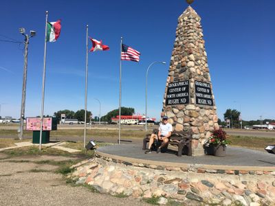
Geographical Center of North America Monument, Stone monument in Rugby, North Dakota.
The Geographical Center of North America Monument is a pyramid-shaped stone structure approximately 21 feet tall, built on a heart-shaped foundation at a road intersection. Three national flags mark the location, which sits at the corner of two major highways.
In 1931, the U.S. Geological Survey officially identified this location as North America's geographical center through continental measurements. The site was then marked to establish a permanent geographic reference point.
The monument has become central to Rugby's local identity and community pride. The town has built celebrations and traditions around this geographic marker, making it a source of civic distinction.
The monument is located at a road intersection with convenient parking nearby for visitors. The site is small and can be explored quickly, making it easy to fit into a traveling schedule.
The center was determined using an unusual method where surveyors balanced a cardboard cutout of North America on a pencil point. This simple yet effective technique allowed them to find the continent's equilibrium point.
Location: North Dakota
GPS coordinates: 48.35443,-99.99808
Latest update: December 6, 2025 19:08
International Peace Garden
72 km
Fort Totten State Historic Site
85.6 km
Coghlan Castle
68.9 km
Vang Evangelical Lutheran Church
75.7 km
J. Clark Salyer National Wildlife Refuge
59.5 km
St. John–Lena Border Crossing
76 km
Viking Lutheran Church
66.6 km
Liberty Baptist Church
67.9 km
Benson County Courthouse
64 km
U.S. Post Office and Courthouse
88.7 km
McHenry County Courthouse
30 km
Westgaard Bridge
65.8 km
Ramsey County Sheriff's House
88.6 km
Urbain Cote Round Barn
79.2 km
Rugby Post Office
1.8 km
Devils Lake Carnegie Library
88.5 km
Old Main
62.5 km
Granville State Bank
62.7 km
Westminster Presbyterian Church
88.6 km
Pierce County Courthouse
1.6 km
Towner County Courthouse
60.6 km
Alfred and Clara Sevareid House
76.5 km
Episcopal Church of the Advent and Guild Hall
88.7 km
Wells County Courthouse
83.3 km
Bangs-Wineman Block
88.3 km
Lake Metigoshe State Park
74.4 km
Prairie Village Museum
312 m
Fort Totten
85.6 kmVisited this place? Tap the stars to rate it and share your experience / photos with the community! Try now! You can cancel it anytime.
Discover hidden gems everywhere you go!
From secret cafés to breathtaking viewpoints, skip the crowded tourist spots and find places that match your style. Our app makes it easy with voice search, smart filtering, route optimization, and insider tips from travelers worldwide. Download now for the complete mobile experience.
A unique approach to discovering new places❞
— Le Figaro
All the places worth exploring❞
— France Info
A tailor-made excursion in just a few clicks❞
— 20 Minutes