See the monuments around you in AROpen chests in the app
Around Us is built for your phone — point your camera at the streets and discover the monuments and places around you in augmented reality.Around Us is built for your phone — chests unlock when you walk, explore and capture nearby places.
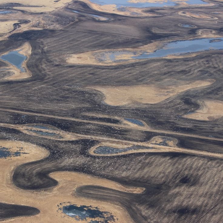
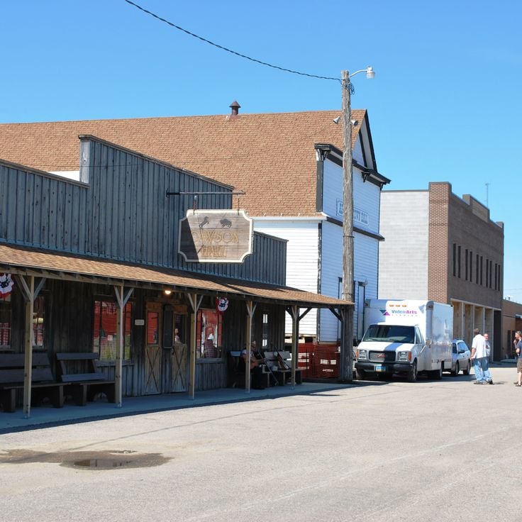
North Dakota is a Great Plains state with a history shaped by trading posts, military forts, and Native American settlements. The region stretches from the Missouri River to the Canadian border, preserving sites that tell stories from the 19th century alongside Cold War relics and natural areas. Visitors find military installations turned into museums, archaeological sites, and parks that protect bison, prairie, and forest.The locations include Theodore Roosevelt National Park with its badlands formations, Fort Union Trading Post from the fur trade era, and Knife River Indian Villages National Historic Site, where earth lodge foundations recall earlier communities. The Enchanted Highway displays large metal sculptures along the road, while Nekoma Missile Site and Ronald Reagan Minuteman Missile Site provide views into the missile defense systems of the 1970s. State parks like Fort Ransom and Icelandic preserve river valleys and woodlands. Museums in Fargo and Minot showcase aviation history. The Center of North America Monument in Rugby marks a geographic midpoint, and Bonanzaville USA displays historical buildings from pioneer times.
North Dakota is a Great Plains state with a history shaped by trading posts, military forts, and Native American settlements. The region stretches from the Missouri River to the Canadian border, preserving sites that tell stories from the 19th century alongside Cold War relics and natural areas. Visitors find military installations turned into museums, archaeological sites, and parks that protect bison, prairie, and forest.The locations include Theodore Roosevelt National Park with its badlands formations, Fort Union Trading Post from the fur trade era, and Knife River Indian Villages National Historic Site, where earth lodge foundations recall earlier communities. The Enchanted Highway displays large metal sculptures along the road, while Nekoma Missile Site and Ronald Reagan Minuteman Missile Site provide views into the missile defense systems of the 1970s. State parks like Fort Ransom and Icelandic preserve river valleys and woodlands. Museums in Fargo and Minot showcase aviation history. The Center of North America Monument in Rugby marks a geographic midpoint, and Bonanzaville USA displays historical buildings from pioneer times.
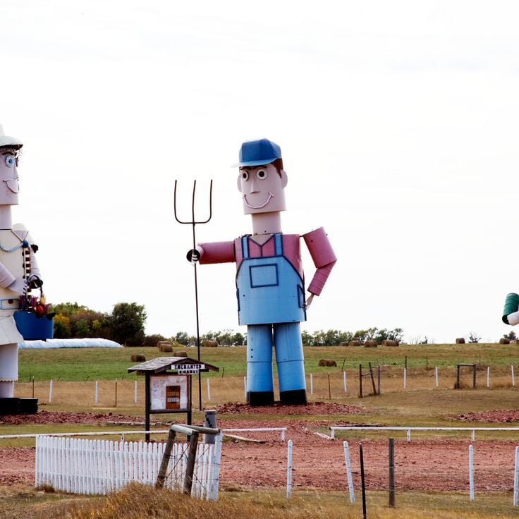
This 32-mile (51-kilometer) route crosses the prairie with seven tall metal sculptures made from old farm equipment and scrap. A local artist built these figures to draw travelers and support the area. The works rise above the flat land and show themes from rural life, including birds, fish and insects at large scale. Visitors drive between small towns and stop at each site to see the pieces up close. The road connects Regent to Interstate 94, passing through open farmland where the sculptures stand alone against the horizon.
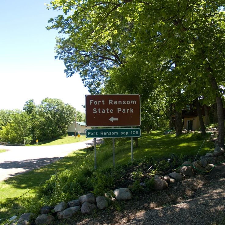
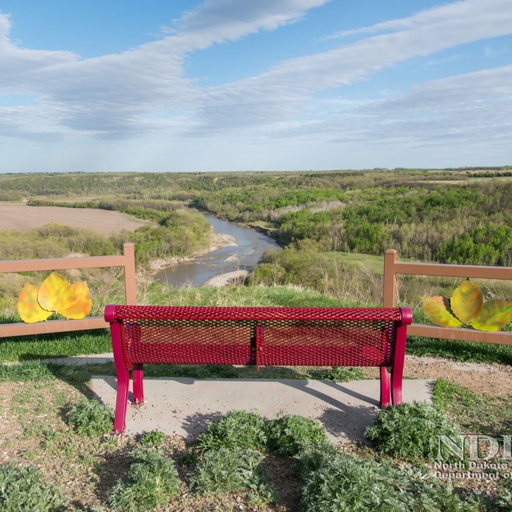
This park covers around 950 acres in the Sheyenne River Valley and preserves a military outpost from 1867. Visitors walk trails through wooded valleys and along the river, camp on simple sites and explore remains of the garrison. Grassland and forest alternate, the valley lies lower than the surrounding plains. In fall the trees turn red and gold. Families use the park for picnics and short walks, anglers cast lines into the river, photographers come for sunrise and sunset.
This gorge sits in Pembina County and runs through a rock formation shaped by erosion over centuries. The terrain shows different layers of stone and offers trails for walking and cycling through wooded slopes. Visitors experience a quiet landscape with views over valleys and riverbeds that belong to the natural environment of North Dakota.
This state park preserves an Icelandic immigration museum, lakeside trails and a reconstructed pioneer house from the 1880s, reflecting the history of early Icelandic settlers in North Dakota who arrived in this area and built new communities while maintaining their heritage and customs.
Nekoma Missile Site is a military complex from the 1970s in Cavalier County that included missile silos and underground command centers built to defend against Soviet attacks during the Cold War. This site demonstrates the defense strategies of that era and stands among the few remaining installations of this kind in North Dakota, serving today as an example of Cold War military architecture.
This nature reserve protects forests, grasslands and wetlands in Benson County and provides habitat for more than 250 bird species and native mammals. Sullys Hill National Game Preserve maintains prairie landscapes in North Dakota that shelter bison, elk and white-tailed deer. Visitors follow trails through different habitats and observe wildlife in their natural surroundings. The preserve sits near Devils Lake and connects wooded areas with open grasslands typical of the region.
This roadside viewpoint displays round rock formations created by mineral deposits millions of years ago. The sphere-shaped stones reach diameters between 10 and 20 feet (3 to 6 meters) and rest scattered across the prairie landscape. Visitors stop at this point to observe the geological structures formed through natural cementation of sediments. The formation belongs to the natural features found in the northern Great Plains region.
This park protects 2,300 hectares (5,600 acres) of original forests along the Missouri River in North Dakota and offers a network of trails through grassland and wooded river bottoms. Cross Ranch State Park preserves natural habitats that show what the landscape looked like before European settlement. Visitors walk through tall grass prairies, explore wooded areas near the water and observe wildlife in one of the state's least altered river landscapes.
This 26-room residence was built in 1883 by the French Marquis de Mores and reflects a time when European aristocrats ventured into the American prairies. The Chateau de Mores State Historic Site stands near Medora and preserves the original furniture and interior arrangements of the late 19th century. Visitors walk through parlors, bedrooms and service quarters that show how a French nobleman lived in North Dakota during the ranching era.
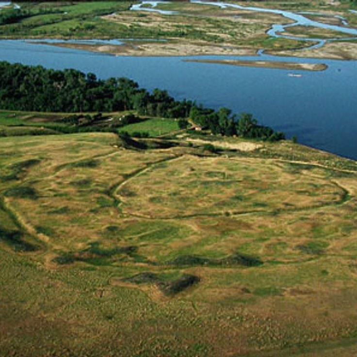
This archaeological site preserves the remains of a 15th-century Mandan settlement with earth lodges and defensive trenches. The village shows two parallel ditches that protected the location, while circular depressions in the ground mark where the dwellings once stood. The Mandan built their homes using wooden frames covered with earth, creating lasting structures. The trenches served as barriers against attacks and helped secure the community. Today visitors can walk through the grounds and see the outlines of the old structures rising gently across the prairie landscape.
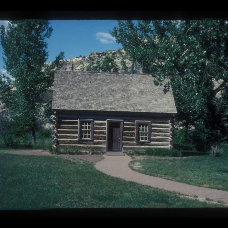
This property held Theodore Roosevelt's ranch from 1884 to 1887, where he spent time after his wife's death. The site sits in rural McKenzie County, surrounded by the Little Missouri River Badlands landscape. The original buildings are gone, but visitors can explore the cabin foundations, fence posts and archaeological remains. Trails lead through the prairie where Roosevelt developed his conservation views, which later shaped American environmental policy.
This trading post from the 1840s shows the life of Métis traders and the organization of fur trade operations in the region. The wooden buildings preserve rooms where traders stored pelts and conducted business with Dakota tribes. Visitors see living quarters, storage areas and tools from the period when fur trade shaped the economy of the northern prairie. The Gingras Trading Post State Historic Site documents the role of Métis people in the border region between American and British territory during the mid-19th century.
This museum displays minerals, rocks and crystals gathered from the northern plains of North America and from distant countries. The collection grew through decades of private work and includes pieces from local quarries as well as international finds. Visitors see samples in different colors and textures, from polished quartz to weathered field stones, illustrating the geological variety of the earth.
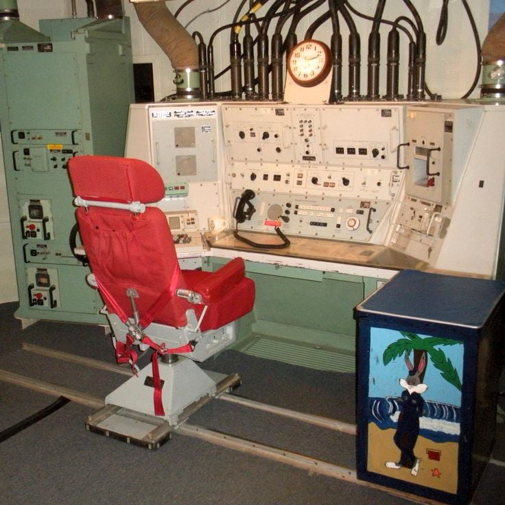
This Cold War military installation near Cooperstown housed intercontinental ballistic missiles in underground silos. The site shows a missile launch silo, a control room with original equipment and protective bunkers. Visitors see computer systems, communication devices and the reinforced concrete structures built several meters below ground level to protect and operate the weapons.
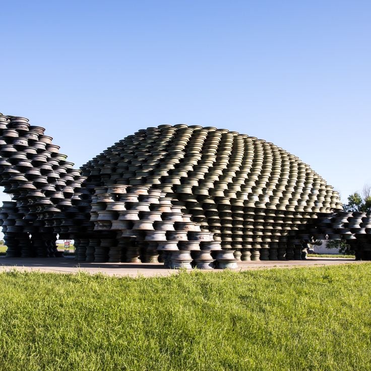
This metal turtle sculpture is built from 2000 car wheel rims and stands as a creative reuse of materials in one of North Dakota's rural areas. The construction reaches about 40 feet (12 meters) in length and 20 feet (6 meters) in height, making it visible from a distance and attracting travelers looking for unusual roadside attractions.
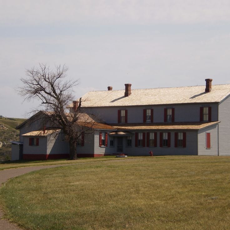
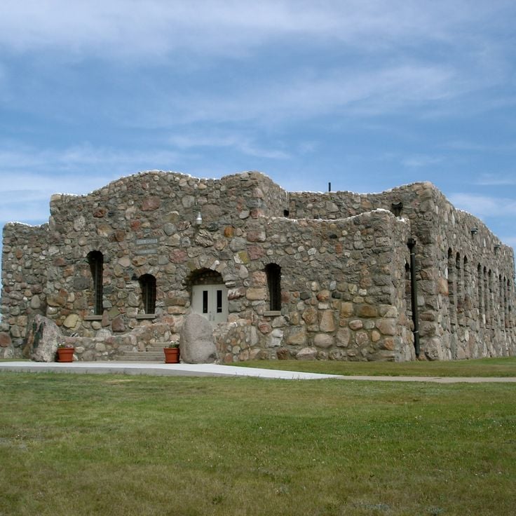
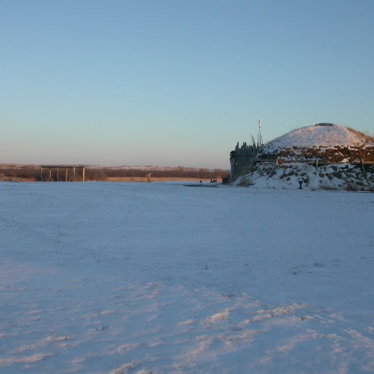
This 19th-century military post stands in Benson County with its original buildings, showing American army history on the prairie. Fort Totten State Historic Site was built during the 1860s and remains one of the best preserved frontier military installations. The brick structures include barracks, officers' quarters and administrative buildings. A museum documents the life of soldiers and relations with Dakota communities. Visitors see weapons, uniforms and everyday items from the Indian Wars period.
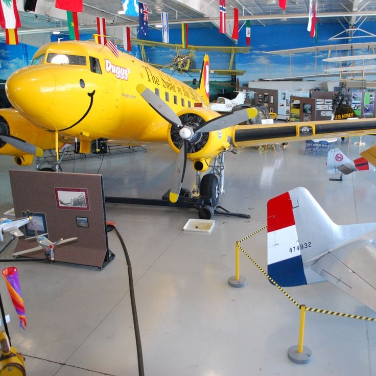
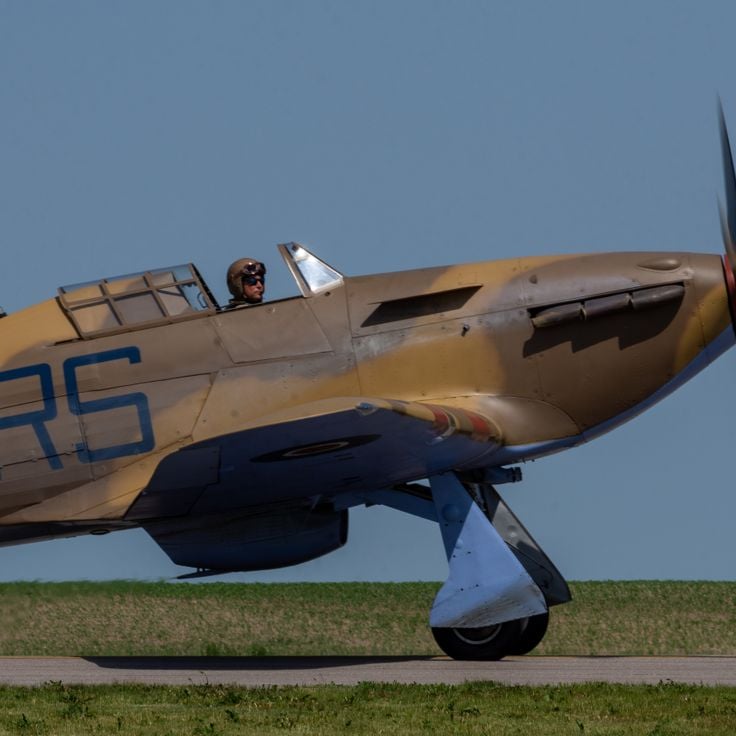
This museum displays more than 90 historical military and civilian aircraft alongside technical equipment, uniforms and documents that trace aviation history. The collection spans machines from different eras and offers insight into how flight developed over time. Visitors see cockpits, engines and personal items from pilots that bring the human side of flying into focus.
This tunnel and bridge once served the rail line connecting extraction fields in the northwest with loading terminals along the Yellowstone River. The route passed through steep slopes and across the water. Today the path runs through the interior of the hill and over the steel structure that spans the river. Walking here, you see the bends of the river, the high banks and the wide plain. The trail links both sides of the valley and follows the old route through the landscape at the edge of North Dakota.
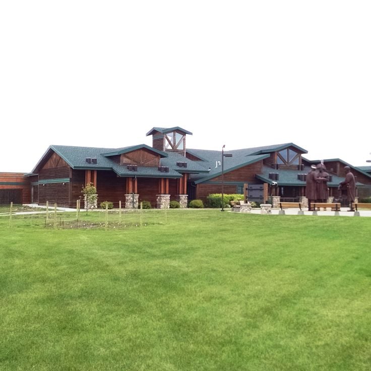
This interactive center explores the journey of Lewis and Clark through North Dakota territory. Visitors find exhibits on the historic expedition routes along the Missouri River and can see a full-size replica keelboat similar to the one used by the explorers in the early 1800s. The presentations connect the story of exploration with the geography of the region and show how the expedition changed understanding of the northern Great Plains.
This museum in Minot preserves North Dakota's aviation history and displays historic aircraft from different eras. The collection includes restored planes, engines and instruments that document how flight developed in the region. Visitors see military aircraft, civilian propeller planes and can walk through hangars where mechanics work on restoring old models. The Dakota Territory Air Museum connects technical details with personal stories of pilots and engineers who flew over the Great Plains.
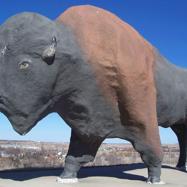
This concrete sculpture in the shape of an American bison stands in Pioneer Park and ranks among the largest animal statues in North America. The figure was created to honor the role of bison in the history of the Great Plains. A walking path circles the statue, offering views that convey the scale of the work. The park sits along the interstate and provides several lookout points. The statue is surrounded by green space and serves as a local landmark.
This park covers nearly 1700 acres and includes walking paths, fishing areas and camping grounds set among low hills and stands of aspen. The landscape follows the shore of Lake Metigoshe, where wooded valleys open toward the water. Visitors walk trails that wind through light forests, where aspen leaves turn gold in autumn. The lake offers fishing and boating, while the surrounding hills provide broad views across the region. Camping areas are placed along the shore and within the woods, allowing overnight guests to experience the quiet of the outdoors.
This site preserves the remains of Hidatsa villages from the 18th and 19th centuries. The settlements consisted of earth lodges, and circular depressions still mark where families lived. Farmers and hunters cultivated corn, beans and squash here while trading along the river. The grounds show how people built their homes and organized daily life. A visitor center displays tools, pottery and other objects from everyday activities. Trails lead through the landscape where hundreds of families once gathered.
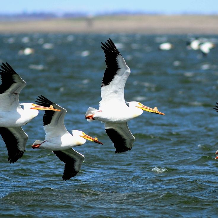
This refuge holds one of the largest pelican colonies in North America, providing habitat for thousands of white pelicans that nest on an island in the lake. Chase Lake National Wildlife Refuge spreads across prairie grasslands and wetlands, where large flocks of birds gather during summer months. Visitors can watch the white birds circle over the water or float on the surface from the shoreline. The area protects grasslands and smaller ponds that serve as resting places for many other bird species.
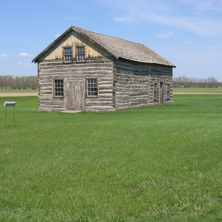
Bonanzaville USA preserves 43 historic buildings from the 1800s that show how early settlers lived in North Dakota. This open-air museum in West Fargo includes a church, a school, and a railway station from the pioneer era. Visitors walk through the streets of a recreated town and see how families, merchants, and railroad workers lived and worked. The collection displays tools, furniture, and everyday objects that document life on the prairies during settlement times.
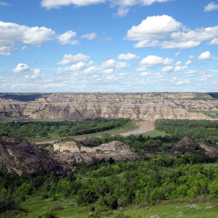
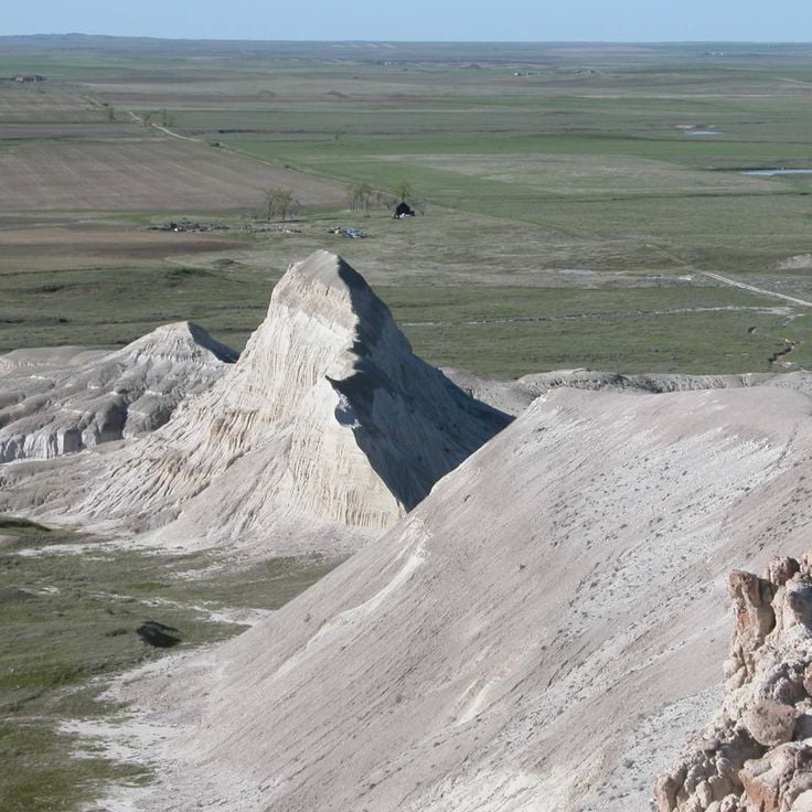
This national park covers the Badlands of western North Dakota and protects a landscape of eroded hills, grasslands, and the Little Missouri River. Bison graze on the prairies, elk move through the valleys, and wild horses roam the open country. Layered rock formations glow in the sunlight, while prairie dogs build their colonies in the soft earth. Hiking trails lead to overlooks above winding river canyons and windswept plateaus, where silence is broken only by distant bird calls.
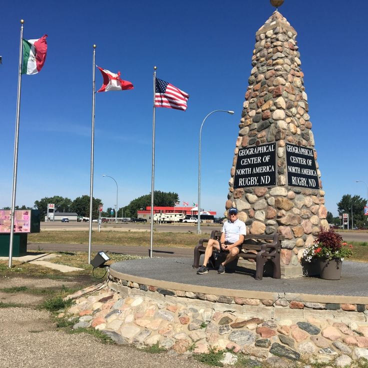
This monument of stone with an obelisk has marked the mathematically calculated geographic center of the North American continent since 1932. A small pavilion of fieldstone surrounds the marker in Rugby. The calculations date from the 19th century and were based on the known extent of North America at that time. The site was later commemorated with this stone. Visitors find a maintained lawn and informational panels about the history of the survey. The center sits near the main road and is visited by travelers passing through the Great Plains.
This park celebrates Nordic culture with a stave church built in the Norwegian tradition, a monument to the state mascot gopher and a plaza where flags from Scandinavian nations fly. The buildings follow original construction styles from Norway, Sweden, Denmark, Finland and Iceland. Visitors see wooden structures with carved details, traditional roofs and interiors that recall historic Nordic settlements. The park shows how immigrants from these regions brought their customs and craftsmanship to North Dakota and made a new home here.
White Butte is the highest point in North Dakota, reaching 3,506 feet (1,069 meters) and composed of pale sandstone that gives the hill its name. The elevation rises from grassland near the South Dakota border. A trail leads from the base to the summit, where views extend across the rolling prairie. The light color of the rock stands out against the surrounding grass, especially in sunlight. The climb takes about an hour, with a steep path that requires no technical skill. A survey marker sits at the top, identifying this spot as the state's highest elevation.
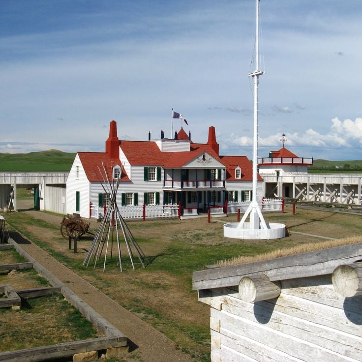
This reconstructed trading post from the 19th century displays palisade walls, bastions and buildings that document the fur trade with indigenous peoples. Fort Union Trading Post National Historic Site preserves the history of an important meeting place between European traders and Plains tribes. Visitors see rooms with furniture and tools from the trading era, walk through the courtyard and learn about the role this place played in the exchange of goods and cultures.
This protected area in northeastern LaMoure County provides habitat for migrating and resident birds. The Kulm Wetland Management District supports conservation programs and includes observation stations and trails through the wetlands. Visitors can watch ducks, geese and wading birds across different seasons. The landscape consists of shallow pools, prairie grasslands and reed zones that make the area an important stopover for traveling bird species.
This 32-mile (51-kilometer) route crosses the prairie with seven tall metal sculptures made from old farm equipment and scrap. A local artist built these figures to draw travelers and support the area. The works rise above the flat land and show themes from rural life, including birds, fish and insects at large scale. Visitors drive between small towns and stop at each site to see the pieces up close. The road connects Regent to Interstate 94, passing through open farmland where the sculptures stand alone against the horizon.
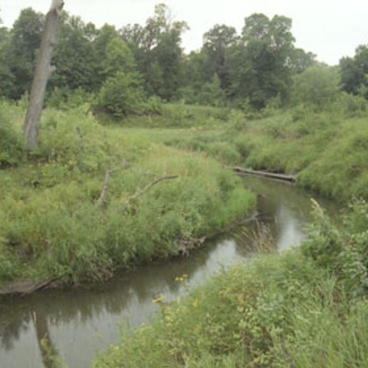
This park covers around 950 acres in the Sheyenne River Valley and preserves a military outpost from 1867. Visitors walk trails through wooded valleys and along the river, camp on simple sites and explore remains of the garrison. Grassland and forest alternate, the valley lies lower than the surrounding plains. In fall the trees turn red and gold. Families use the park for picnics and short walks, anglers cast lines into the river, photographers come for sunrise and sunset.
This gorge sits in Pembina County and runs through a rock formation shaped by erosion over centuries. The terrain shows different layers of stone and offers trails for walking and cycling through wooded slopes. Visitors experience a quiet landscape with views over valleys and riverbeds that belong to the natural environment of North Dakota.
This state park preserves an Icelandic immigration museum, lakeside trails and a reconstructed pioneer house from the 1880s, reflecting the history of early Icelandic settlers in North Dakota who arrived in this area and built new communities while maintaining their heritage and customs.
Nekoma Missile Site is a military complex from the 1970s in Cavalier County that included missile silos and underground command centers built to defend against Soviet attacks during the Cold War. This site demonstrates the defense strategies of that era and stands among the few remaining installations of this kind in North Dakota, serving today as an example of Cold War military architecture.
This nature reserve protects forests, grasslands and wetlands in Benson County and provides habitat for more than 250 bird species and native mammals. Sullys Hill National Game Preserve maintains prairie landscapes in North Dakota that shelter bison, elk and white-tailed deer. Visitors follow trails through different habitats and observe wildlife in their natural surroundings. The preserve sits near Devils Lake and connects wooded areas with open grasslands typical of the region.
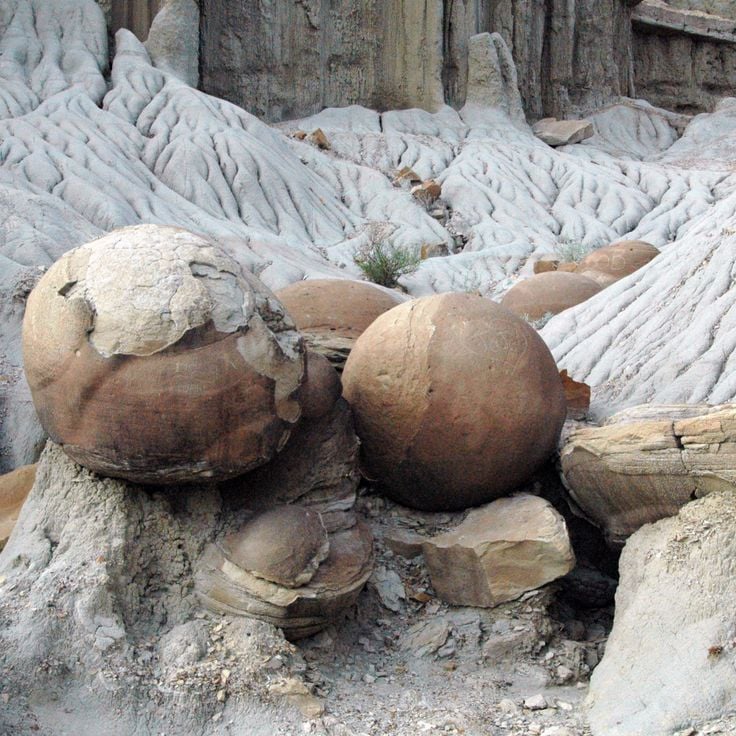
This roadside viewpoint displays round rock formations created by mineral deposits millions of years ago. The sphere-shaped stones reach diameters between 10 and 20 feet (3 to 6 meters) and rest scattered across the prairie landscape. Visitors stop at this point to observe the geological structures formed through natural cementation of sediments. The formation belongs to the natural features found in the northern Great Plains region.
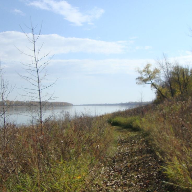
This park protects 2,300 hectares (5,600 acres) of original forests along the Missouri River in North Dakota and offers a network of trails through grassland and wooded river bottoms. Cross Ranch State Park preserves natural habitats that show what the landscape looked like before European settlement. Visitors walk through tall grass prairies, explore wooded areas near the water and observe wildlife in one of the state's least altered river landscapes.
This 26-room residence was built in 1883 by the French Marquis de Mores and reflects a time when European aristocrats ventured into the American prairies. The Chateau de Mores State Historic Site stands near Medora and preserves the original furniture and interior arrangements of the late 19th century. Visitors walk through parlors, bedrooms and service quarters that show how a French nobleman lived in North Dakota during the ranching era.
This archaeological site preserves the remains of a 15th-century Mandan settlement with earth lodges and defensive trenches. The village shows two parallel ditches that protected the location, while circular depressions in the ground mark where the dwellings once stood. The Mandan built their homes using wooden frames covered with earth, creating lasting structures. The trenches served as barriers against attacks and helped secure the community. Today visitors can walk through the grounds and see the outlines of the old structures rising gently across the prairie landscape.
This property held Theodore Roosevelt's ranch from 1884 to 1887, where he spent time after his wife's death. The site sits in rural McKenzie County, surrounded by the Little Missouri River Badlands landscape. The original buildings are gone, but visitors can explore the cabin foundations, fence posts and archaeological remains. Trails lead through the prairie where Roosevelt developed his conservation views, which later shaped American environmental policy.
This trading post from the 1840s shows the life of Métis traders and the organization of fur trade operations in the region. The wooden buildings preserve rooms where traders stored pelts and conducted business with Dakota tribes. Visitors see living quarters, storage areas and tools from the period when fur trade shaped the economy of the northern prairie. The Gingras Trading Post State Historic Site documents the role of Métis people in the border region between American and British territory during the mid-19th century.
This museum displays minerals, rocks and crystals gathered from the northern plains of North America and from distant countries. The collection grew through decades of private work and includes pieces from local quarries as well as international finds. Visitors see samples in different colors and textures, from polished quartz to weathered field stones, illustrating the geological variety of the earth.
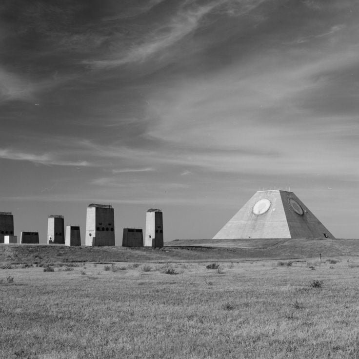
This Cold War military installation near Cooperstown housed intercontinental ballistic missiles in underground silos. The site shows a missile launch silo, a control room with original equipment and protective bunkers. Visitors see computer systems, communication devices and the reinforced concrete structures built several meters below ground level to protect and operate the weapons.
This metal turtle sculpture is built from 2000 car wheel rims and stands as a creative reuse of materials in one of North Dakota's rural areas. The construction reaches about 40 feet (12 meters) in length and 20 feet (6 meters) in height, making it visible from a distance and attracting travelers looking for unusual roadside attractions.
This 19th-century military post stands in Benson County with its original buildings, showing American army history on the prairie. Fort Totten State Historic Site was built during the 1860s and remains one of the best preserved frontier military installations. The brick structures include barracks, officers' quarters and administrative buildings. A museum documents the life of soldiers and relations with Dakota communities. Visitors see weapons, uniforms and everyday items from the Indian Wars period.
This museum displays more than 90 historical military and civilian aircraft alongside technical equipment, uniforms and documents that trace aviation history. The collection spans machines from different eras and offers insight into how flight developed over time. Visitors see cockpits, engines and personal items from pilots that bring the human side of flying into focus.
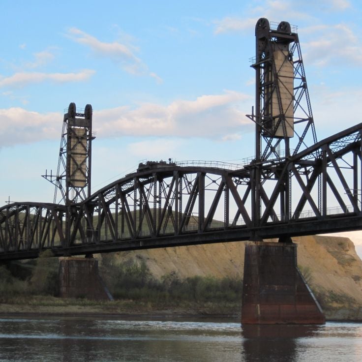
This tunnel and bridge once served the rail line connecting extraction fields in the northwest with loading terminals along the Yellowstone River. The route passed through steep slopes and across the water. Today the path runs through the interior of the hill and over the steel structure that spans the river. Walking here, you see the bends of the river, the high banks and the wide plain. The trail links both sides of the valley and follows the old route through the landscape at the edge of North Dakota.
This interactive center explores the journey of Lewis and Clark through North Dakota territory. Visitors find exhibits on the historic expedition routes along the Missouri River and can see a full-size replica keelboat similar to the one used by the explorers in the early 1800s. The presentations connect the story of exploration with the geography of the region and show how the expedition changed understanding of the northern Great Plains.
This museum in Minot preserves North Dakota's aviation history and displays historic aircraft from different eras. The collection includes restored planes, engines and instruments that document how flight developed in the region. Visitors see military aircraft, civilian propeller planes and can walk through hangars where mechanics work on restoring old models. The Dakota Territory Air Museum connects technical details with personal stories of pilots and engineers who flew over the Great Plains.
This concrete sculpture in the shape of an American bison stands in Pioneer Park and ranks among the largest animal statues in North America. The figure was created to honor the role of bison in the history of the Great Plains. A walking path circles the statue, offering views that convey the scale of the work. The park sits along the interstate and provides several lookout points. The statue is surrounded by green space and serves as a local landmark.
This park covers nearly 1700 acres and includes walking paths, fishing areas and camping grounds set among low hills and stands of aspen. The landscape follows the shore of Lake Metigoshe, where wooded valleys open toward the water. Visitors walk trails that wind through light forests, where aspen leaves turn gold in autumn. The lake offers fishing and boating, while the surrounding hills provide broad views across the region. Camping areas are placed along the shore and within the woods, allowing overnight guests to experience the quiet of the outdoors.
This site preserves the remains of Hidatsa villages from the 18th and 19th centuries. The settlements consisted of earth lodges, and circular depressions still mark where families lived. Farmers and hunters cultivated corn, beans and squash here while trading along the river. The grounds show how people built their homes and organized daily life. A visitor center displays tools, pottery and other objects from everyday activities. Trails lead through the landscape where hundreds of families once gathered.
This refuge holds one of the largest pelican colonies in North America, providing habitat for thousands of white pelicans that nest on an island in the lake. Chase Lake National Wildlife Refuge spreads across prairie grasslands and wetlands, where large flocks of birds gather during summer months. Visitors can watch the white birds circle over the water or float on the surface from the shoreline. The area protects grasslands and smaller ponds that serve as resting places for many other bird species.
Bonanzaville USA preserves 43 historic buildings from the 1800s that show how early settlers lived in North Dakota. This open-air museum in West Fargo includes a church, a school, and a railway station from the pioneer era. Visitors walk through the streets of a recreated town and see how families, merchants, and railroad workers lived and worked. The collection displays tools, furniture, and everyday objects that document life on the prairies during settlement times.
This national park covers the Badlands of western North Dakota and protects a landscape of eroded hills, grasslands, and the Little Missouri River. Bison graze on the prairies, elk move through the valleys, and wild horses roam the open country. Layered rock formations glow in the sunlight, while prairie dogs build their colonies in the soft earth. Hiking trails lead to overlooks above winding river canyons and windswept plateaus, where silence is broken only by distant bird calls.
This monument of stone with an obelisk has marked the mathematically calculated geographic center of the North American continent since 1932. A small pavilion of fieldstone surrounds the marker in Rugby. The calculations date from the 19th century and were based on the known extent of North America at that time. The site was later commemorated with this stone. Visitors find a maintained lawn and informational panels about the history of the survey. The center sits near the main road and is visited by travelers passing through the Great Plains.
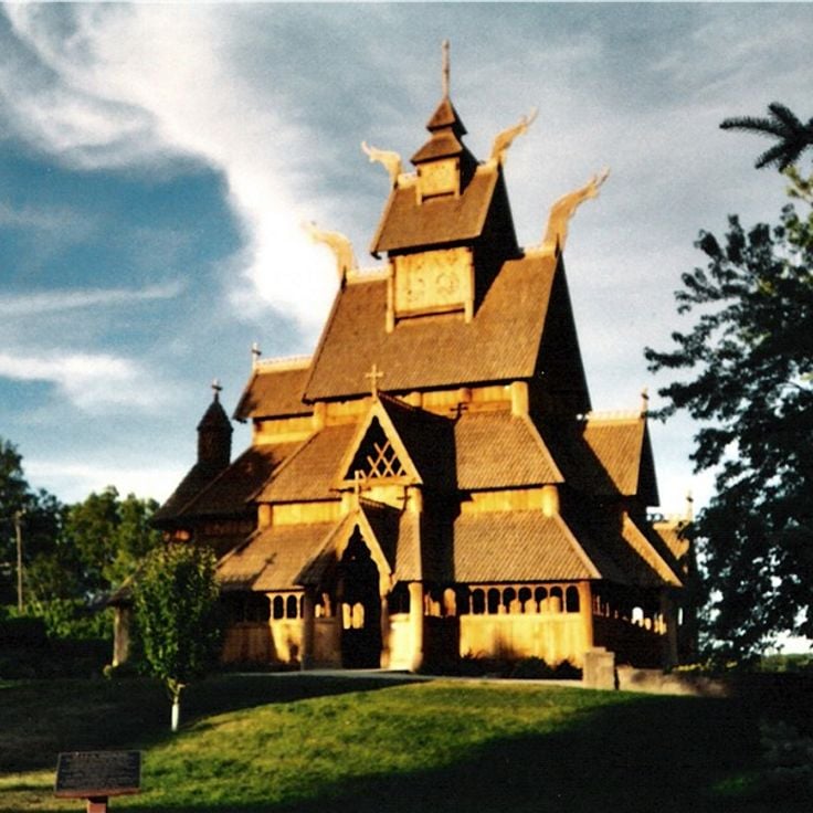
This park celebrates Nordic culture with a stave church built in the Norwegian tradition, a monument to the state mascot gopher and a plaza where flags from Scandinavian nations fly. The buildings follow original construction styles from Norway, Sweden, Denmark, Finland and Iceland. Visitors see wooden structures with carved details, traditional roofs and interiors that recall historic Nordic settlements. The park shows how immigrants from these regions brought their customs and craftsmanship to North Dakota and made a new home here.
White Butte is the highest point in North Dakota, reaching 3,506 feet (1,069 meters) and composed of pale sandstone that gives the hill its name. The elevation rises from grassland near the South Dakota border. A trail leads from the base to the summit, where views extend across the rolling prairie. The light color of the rock stands out against the surrounding grass, especially in sunlight. The climb takes about an hour, with a steep path that requires no technical skill. A survey marker sits at the top, identifying this spot as the state's highest elevation.
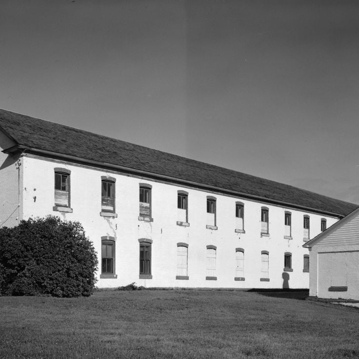
This reconstructed trading post from the 19th century displays palisade walls, bastions and buildings that document the fur trade with indigenous peoples. Fort Union Trading Post National Historic Site preserves the history of an important meeting place between European traders and Plains tribes. Visitors see rooms with furniture and tools from the trading era, walk through the courtyard and learn about the role this place played in the exchange of goods and cultures.
This protected area in northeastern LaMoure County provides habitat for migrating and resident birds. The Kulm Wetland Management District supports conservation programs and includes observation stations and trails through the wetlands. Visitors can watch ducks, geese and wading birds across different seasons. The landscape consists of shallow pools, prairie grasslands and reed zones that make the area an important stopover for traveling bird species.
This 32-mile (51-kilometer) route crosses the prairie with seven tall metal sculptures made from old farm equipment and scrap. A local artist built these figures to draw travelers and support the area. The works rise above the flat land and show themes from rural life, including birds, fish and insects at large scale. Visitors drive between small towns and stop at each site to see the pieces up close. The road connects Regent to Interstate 94, passing through open farmland where the sculptures stand alone against the horizon.
This park covers around 950 acres in the Sheyenne River Valley and preserves a military outpost from 1867. Visitors walk trails through wooded valleys and along the river, camp on simple sites and explore remains of the garrison. Grassland and forest alternate, the valley lies lower than the surrounding plains. In fall the trees turn red and gold. Families use the park for picnics and short walks, anglers cast lines into the river, photographers come for sunrise and sunset.
This gorge sits in Pembina County and runs through a rock formation shaped by erosion over centuries. The terrain shows different layers of stone and offers trails for walking and cycling through wooded slopes. Visitors experience a quiet landscape with views over valleys and riverbeds that belong to the natural environment of North Dakota.
This state park preserves an Icelandic immigration museum, lakeside trails and a reconstructed pioneer house from the 1880s, reflecting the history of early Icelandic settlers in North Dakota who arrived in this area and built new communities while maintaining their heritage and customs.
Nekoma Missile Site is a military complex from the 1970s in Cavalier County that included missile silos and underground command centers built to defend against Soviet attacks during the Cold War. This site demonstrates the defense strategies of that era and stands among the few remaining installations of this kind in North Dakota, serving today as an example of Cold War military architecture.
This nature reserve protects forests, grasslands and wetlands in Benson County and provides habitat for more than 250 bird species and native mammals. Sullys Hill National Game Preserve maintains prairie landscapes in North Dakota that shelter bison, elk and white-tailed deer. Visitors follow trails through different habitats and observe wildlife in their natural surroundings. The preserve sits near Devils Lake and connects wooded areas with open grasslands typical of the region.
This roadside viewpoint displays round rock formations created by mineral deposits millions of years ago. The sphere-shaped stones reach diameters between 10 and 20 feet (3 to 6 meters) and rest scattered across the prairie landscape. Visitors stop at this point to observe the geological structures formed through natural cementation of sediments. The formation belongs to the natural features found in the northern Great Plains region.
This park protects 2,300 hectares (5,600 acres) of original forests along the Missouri River in North Dakota and offers a network of trails through grassland and wooded river bottoms. Cross Ranch State Park preserves natural habitats that show what the landscape looked like before European settlement. Visitors walk through tall grass prairies, explore wooded areas near the water and observe wildlife in one of the state's least altered river landscapes.
This 26-room residence was built in 1883 by the French Marquis de Mores and reflects a time when European aristocrats ventured into the American prairies. The Chateau de Mores State Historic Site stands near Medora and preserves the original furniture and interior arrangements of the late 19th century. Visitors walk through parlors, bedrooms and service quarters that show how a French nobleman lived in North Dakota during the ranching era.
This archaeological site preserves the remains of a 15th-century Mandan settlement with earth lodges and defensive trenches. The village shows two parallel ditches that protected the location, while circular depressions in the ground mark where the dwellings once stood. The Mandan built their homes using wooden frames covered with earth, creating lasting structures. The trenches served as barriers against attacks and helped secure the community. Today visitors can walk through the grounds and see the outlines of the old structures rising gently across the prairie landscape.
This property held Theodore Roosevelt's ranch from 1884 to 1887, where he spent time after his wife's death. The site sits in rural McKenzie County, surrounded by the Little Missouri River Badlands landscape. The original buildings are gone, but visitors can explore the cabin foundations, fence posts and archaeological remains. Trails lead through the prairie where Roosevelt developed his conservation views, which later shaped American environmental policy.
This trading post from the 1840s shows the life of Métis traders and the organization of fur trade operations in the region. The wooden buildings preserve rooms where traders stored pelts and conducted business with Dakota tribes. Visitors see living quarters, storage areas and tools from the period when fur trade shaped the economy of the northern prairie. The Gingras Trading Post State Historic Site documents the role of Métis people in the border region between American and British territory during the mid-19th century.
This museum displays minerals, rocks and crystals gathered from the northern plains of North America and from distant countries. The collection grew through decades of private work and includes pieces from local quarries as well as international finds. Visitors see samples in different colors and textures, from polished quartz to weathered field stones, illustrating the geological variety of the earth.
This Cold War military installation near Cooperstown housed intercontinental ballistic missiles in underground silos. The site shows a missile launch silo, a control room with original equipment and protective bunkers. Visitors see computer systems, communication devices and the reinforced concrete structures built several meters below ground level to protect and operate the weapons.
This metal turtle sculpture is built from 2000 car wheel rims and stands as a creative reuse of materials in one of North Dakota's rural areas. The construction reaches about 40 feet (12 meters) in length and 20 feet (6 meters) in height, making it visible from a distance and attracting travelers looking for unusual roadside attractions.
This 19th-century military post stands in Benson County with its original buildings, showing American army history on the prairie. Fort Totten State Historic Site was built during the 1860s and remains one of the best preserved frontier military installations. The brick structures include barracks, officers' quarters and administrative buildings. A museum documents the life of soldiers and relations with Dakota communities. Visitors see weapons, uniforms and everyday items from the Indian Wars period.
This museum displays more than 90 historical military and civilian aircraft alongside technical equipment, uniforms and documents that trace aviation history. The collection spans machines from different eras and offers insight into how flight developed over time. Visitors see cockpits, engines and personal items from pilots that bring the human side of flying into focus.
This tunnel and bridge once served the rail line connecting extraction fields in the northwest with loading terminals along the Yellowstone River. The route passed through steep slopes and across the water. Today the path runs through the interior of the hill and over the steel structure that spans the river. Walking here, you see the bends of the river, the high banks and the wide plain. The trail links both sides of the valley and follows the old route through the landscape at the edge of North Dakota.
This interactive center explores the journey of Lewis and Clark through North Dakota territory. Visitors find exhibits on the historic expedition routes along the Missouri River and can see a full-size replica keelboat similar to the one used by the explorers in the early 1800s. The presentations connect the story of exploration with the geography of the region and show how the expedition changed understanding of the northern Great Plains.
This museum in Minot preserves North Dakota's aviation history and displays historic aircraft from different eras. The collection includes restored planes, engines and instruments that document how flight developed in the region. Visitors see military aircraft, civilian propeller planes and can walk through hangars where mechanics work on restoring old models. The Dakota Territory Air Museum connects technical details with personal stories of pilots and engineers who flew over the Great Plains.
This concrete sculpture in the shape of an American bison stands in Pioneer Park and ranks among the largest animal statues in North America. The figure was created to honor the role of bison in the history of the Great Plains. A walking path circles the statue, offering views that convey the scale of the work. The park sits along the interstate and provides several lookout points. The statue is surrounded by green space and serves as a local landmark.
This park covers nearly 1700 acres and includes walking paths, fishing areas and camping grounds set among low hills and stands of aspen. The landscape follows the shore of Lake Metigoshe, where wooded valleys open toward the water. Visitors walk trails that wind through light forests, where aspen leaves turn gold in autumn. The lake offers fishing and boating, while the surrounding hills provide broad views across the region. Camping areas are placed along the shore and within the woods, allowing overnight guests to experience the quiet of the outdoors.
This site preserves the remains of Hidatsa villages from the 18th and 19th centuries. The settlements consisted of earth lodges, and circular depressions still mark where families lived. Farmers and hunters cultivated corn, beans and squash here while trading along the river. The grounds show how people built their homes and organized daily life. A visitor center displays tools, pottery and other objects from everyday activities. Trails lead through the landscape where hundreds of families once gathered.
This refuge holds one of the largest pelican colonies in North America, providing habitat for thousands of white pelicans that nest on an island in the lake. Chase Lake National Wildlife Refuge spreads across prairie grasslands and wetlands, where large flocks of birds gather during summer months. Visitors can watch the white birds circle over the water or float on the surface from the shoreline. The area protects grasslands and smaller ponds that serve as resting places for many other bird species.
Bonanzaville USA preserves 43 historic buildings from the 1800s that show how early settlers lived in North Dakota. This open-air museum in West Fargo includes a church, a school, and a railway station from the pioneer era. Visitors walk through the streets of a recreated town and see how families, merchants, and railroad workers lived and worked. The collection displays tools, furniture, and everyday objects that document life on the prairies during settlement times.
This national park covers the Badlands of western North Dakota and protects a landscape of eroded hills, grasslands, and the Little Missouri River. Bison graze on the prairies, elk move through the valleys, and wild horses roam the open country. Layered rock formations glow in the sunlight, while prairie dogs build their colonies in the soft earth. Hiking trails lead to overlooks above winding river canyons and windswept plateaus, where silence is broken only by distant bird calls.
This monument of stone with an obelisk has marked the mathematically calculated geographic center of the North American continent since 1932. A small pavilion of fieldstone surrounds the marker in Rugby. The calculations date from the 19th century and were based on the known extent of North America at that time. The site was later commemorated with this stone. Visitors find a maintained lawn and informational panels about the history of the survey. The center sits near the main road and is visited by travelers passing through the Great Plains.
This park celebrates Nordic culture with a stave church built in the Norwegian tradition, a monument to the state mascot gopher and a plaza where flags from Scandinavian nations fly. The buildings follow original construction styles from Norway, Sweden, Denmark, Finland and Iceland. Visitors see wooden structures with carved details, traditional roofs and interiors that recall historic Nordic settlements. The park shows how immigrants from these regions brought their customs and craftsmanship to North Dakota and made a new home here.
White Butte is the highest point in North Dakota, reaching 3,506 feet (1,069 meters) and composed of pale sandstone that gives the hill its name. The elevation rises from grassland near the South Dakota border. A trail leads from the base to the summit, where views extend across the rolling prairie. The light color of the rock stands out against the surrounding grass, especially in sunlight. The climb takes about an hour, with a steep path that requires no technical skill. A survey marker sits at the top, identifying this spot as the state's highest elevation.
This reconstructed trading post from the 19th century displays palisade walls, bastions and buildings that document the fur trade with indigenous peoples. Fort Union Trading Post National Historic Site preserves the history of an important meeting place between European traders and Plains tribes. Visitors see rooms with furniture and tools from the trading era, walk through the courtyard and learn about the role this place played in the exchange of goods and cultures.
This protected area in northeastern LaMoure County provides habitat for migrating and resident birds. The Kulm Wetland Management District supports conservation programs and includes observation stations and trails through the wetlands. Visitors can watch ducks, geese and wading birds across different seasons. The landscape consists of shallow pools, prairie grasslands and reed zones that make the area an important stopover for traveling bird species.