White Butte

Log in to your account

AroundUs is a community-driven map of interesting places, built by curious explorers like you. It grows with every review, story, and photo you share.
Connect to save your favorite spots, contribute locations, and create personalized routes.
Continue with Google
Continue with Apple
Continue with X
Continue with Facebook
Continue with email
By continuing, you accept our Terms and Conditions and our Privacy Policy
Create an account
Add to collection
Map
Suggest a change
Share

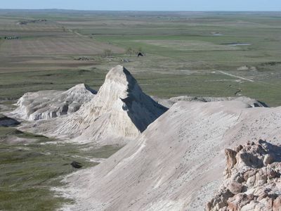
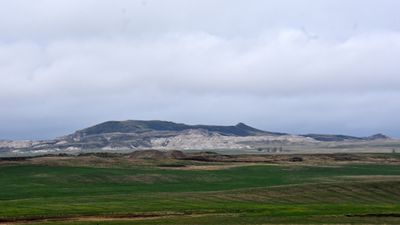
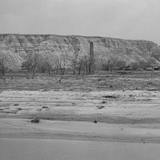
White Butte, Mountain peak in Slope County, United States.

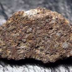
White Butte is the highest point in North Dakota, rising about 1,070 meters (3,510 feet) above the surrounding prairie. The exposed layers of sandstone and older rock at the summit reveal the geological story of this part of the Great Plains.

The butte formed over millions of years as erosion wore away softer layers, leaving behind the more resistant rock that remains today. The rock layers date back to the Oligocene and show how dramatically the landscape shifted over geological time.

The summit draws hikers seeking solitude and a connection to the land, with visitors recording their names and reflections in a logbook left at the top. This simple practice shows how personal and meaningful the place is to those who make the climb.

The route to the summit crosses private property, so stay on the marked trail and watch for cattle gates along the way. Wear sturdy footwear since the ground is uneven and weather can change quickly on the exposed hillside.

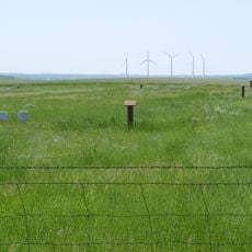
What makes the site special is its complete isolation from other peaks, with no other significant mountains nearby for many miles. This solitude creates a striking landmark that stands out across the otherwise flat prairie.

Location: Slope County

Elevation above the sea: 1,069 m

GPS coordinates: 46.38668,-103.30240

Latest update: December 6, 2025 16:02

Photos
Natural and historical sites in North Dakota

North Dakota is a Great Plains state with a history shaped by trading posts, military forts, and Native American settlements. The region stretches from the Missouri River to the Canadian border, preserving sites that tell stories from the 19th century alongside Cold War relics and natural areas....

Around this place
Enchanted Highway
United States of America

Enchanted Highway

57.9 km
United States of America

Medora Musical

61.6 km
Elkhorn Ranch
United States of America

Elkhorn Ranch

97.4 km
Theodore Roosevelt's Maltese Cross Cabin
United States of America

Theodore Roosevelt's Maltese Cross Cabin

61.4 km
Chateau de Mores
United States of America

Chateau de Mores

61 km
Assumption Abbey
United States of America

Assumption Abbey

93.6 km
Richardton meteorite
United States of America

Richardton meteorite

83.4 km
Fort Dilts
United States of America

Fort Dilts

38.4 km
De Mores Packing Plant Ruins
United States of America

De Mores Packing Plant Ruins

61.4 km
Peaceful Valley Ranch
United States of America

Peaceful Valley Ranch

65.5 km
Von Hoffman House
United States of America

Von Hoffman House

61 km
Dickinson Museum Center
United States of America

Dickinson Museum Center

69.1 km
Saints Peter and Paul Church
United States of America

Saints Peter and Paul Church

75.4 km
St. Mary's Catholic Church
United States of America

St. Mary's Catholic Church

61.1 km
Billings County Courthouse
United States of America

Billings County Courthouse

60.9 km
Mystic Theatre
United States of America

Mystic Theatre

48.7 km
Initial Rock
United States of America

Initial Rock

47.6 km
St. Peter's Catholic Church
United States of America

St. Peter's Catholic Church

95.3 km
Golden Valley Norwegian Lutheran Church
United States of America

Golden Valley Norwegian Lutheran Church

62.4 km
Dickinson Public Library
United States of America

Dickinson Public Library

67.9 km
Hettinger County Courthouse
United States of America

Hettinger County Courthouse

74.8 km
Stark County Courthouse
United States of America

Stark County Courthouse

67.9 km
Cedar Creek Bridge
United States of America

Cedar Creek Bridge

90.9 km
Original Slope County Courthouse
United States of America

Original Slope County Courthouse

10.7 km
Golden Valley County Courthouse
United States of America

Golden Valley County Courthouse

79.4 km
Wibaux Commercial Historic District
United States of America

Wibaux Commercial Historic District

95 km
Adams County Courthouse
United States of America

Adams County Courthouse

67 km
Peace Valley Evangelical Church and Cemetery
United States of America

Peace Valley Evangelical Church and Cemetery

66 km
Show the full map
Reviews

Visited this place? Tap the stars to rate it and share your experience / photos with the community! Try now! You can cancel it anytime.

« White Butte - Mountain peak in Slope County, United States » is provided by Around Us (aroundus.com). Images and texts are derived from Wikimedia project under a Creative Commons license. You are allowed to copy, distribute, and modify copies of this page, under the conditions set by the license, as long as this note is clearly visible.

Discover hidden gems everywhere you go!

From secret cafés to breathtaking viewpoints, skip the crowded tourist spots and find places that match your style. Our app makes it easy with voice search, smart filtering, route optimization, and insider tips from travelers worldwide. Download now for the complete mobile experience.

Around Us App Screenshot

A unique approach to discovering new places

Le Figaro

All the places worth exploring

France Info

A tailor-made excursion in just a few clicks

20 Minutes