Fort Dilts

Log in to your account

AroundUs is a community-driven map of interesting places, built by curious explorers like you. It grows with every review, story, and photo you share.
Connect to save your favorite spots, contribute locations, and create personalized routes.
Continue with Google
Continue with Apple
Continue with X
Continue with Facebook
Continue with email
By continuing, you accept our Terms and Conditions and our Privacy Policy
Create an account
Add to collection
Map
Suggest a change
Share

Fort Dilts, Military fort and historic site in Rhame, North Dakota.

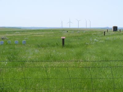
Fort Dilts is a historic site near Rhame preserving the remains of an original sod fortification with a circular layout measuring about 300 feet across. The grounds display visible wagon ruts, grave markers, and interpretive information that help visitors understand the physical layout and construction of the compound.

The fort was built by miners and soldiers in September 1864 during armed conflict with Hunkpapa Sioux warriors. This construction represents a critical moment in the history of American expansion and settlement in the northern Great Plains.

The site tells the story of how settlers and Native Americans shared and competed for this land during a transformative period. What remains visible reflects the daily reality of those tense and difficult times.

The site is located about 8 miles northwest of Rhame and offers free access to visitors. Interpretive signs are positioned throughout to guide your understanding of the remains and their historical context.

The original sod walls survive at their original height of about 6.5 feet in places, making this one of the more intact examples of such frontier construction. This preservation allows visitors to see the actual defensive structure built by those who occupied the site over 150 years ago.

Location: Rhame

GPS coordinates: 46.27869,-103.77623

Latest update: December 9, 2025 20:20

Photos
Around this place
Enchanted Highway
United States of America

Enchanted Highway

95.6 km
United States of America

Medora Musical

72.9 km
Elkhorn Ranch
United States of America

Elkhorn Ranch

107 km
Theodore Roosevelt's Maltese Cross Cabin
United States of America

Theodore Roosevelt's Maltese Cross Cabin

73.6 km
Chateau de Mores
United States of America

Chateau de Mores

72.8 km
Medicine Rocks State Park
United States of America

Medicine Rocks State Park

59.6 km
Bowman-Haley Dam
United States of America

Bowman-Haley Dam

52.5 km
De Mores Packing Plant Ruins
United States of America

De Mores Packing Plant Ruins

73.5 km
Peaceful Valley Ranch
United States of America

Peaceful Valley Ranch

78.5 km
Von Hoffman House
United States of America

Von Hoffman House

73.3 km
Dickinson Museum Center
United States of America

Dickinson Museum Center

102.3 km
Saints Peter and Paul Church
United States of America

Saints Peter and Paul Church

105.4 km
St. Mary's Catholic Church
United States of America

St. Mary's Catholic Church

73.4 km
Carter County Museum
United States of America

Carter County Museum

73.5 km
Billings County Courthouse
United States of America

Billings County Courthouse

73.2 km
Mystic Theatre
United States of America

Mystic Theatre

11.4 km
Initial Rock
United States of America

Initial Rock

65.2 km
St. Peter's Catholic Church
United States of America

St. Peter's Catholic Church

85 km
Golden Valley Norwegian Lutheran Church
United States of America

Golden Valley Norwegian Lutheran Church

77.9 km
Dickinson Public Library
United States of America

Dickinson Public Library

101.2 km
Stark County Courthouse
United States of America

Stark County Courthouse

101.4 km
Original Slope County Courthouse
United States of America

Original Slope County Courthouse

41.6 km
Golden Valley County Courthouse
United States of America

Golden Valley County Courthouse

72.8 km
Wibaux Commercial Historic District
United States of America

Wibaux Commercial Historic District

84.8 km
Adams County Courthouse
United States of America

Adams County Courthouse

93.3 km
Cottonwood Creek Bridge
United States of America

Cottonwood Creek Bridge

80.2 km
Peace Valley Evangelical Church and Cemetery
United States of America

Peace Valley Evangelical Church and Cemetery

78.6 km
Three V Crossing
United States of America

Three V Crossing

31 km
Show the full map
Reviews

Visited this place? Tap the stars to rate it and share your experience / photos with the community! Try now! You can cancel it anytime.

« Fort Dilts - Military fort and historic site in Rhame, North Dakota » is provided by Around Us (aroundus.com). Images and texts are derived from Wikimedia project under a Creative Commons license. You are allowed to copy, distribute, and modify copies of this page, under the conditions set by the license, as long as this note is clearly visible.

Discover hidden gems everywhere you go!

From secret cafés to breathtaking viewpoints, skip the crowded tourist spots and find places that match your style. Our app makes it easy with voice search, smart filtering, route optimization, and insider tips from travelers worldwide. Download now for the complete mobile experience.

Around Us App Screenshot

A unique approach to discovering new places

Le Figaro

All the places worth exploring

France Info

A tailor-made excursion in just a few clicks

20 Minutes