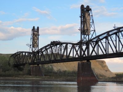
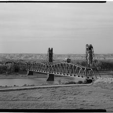
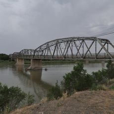
Fairview Lift Bridge, Railway bridge in McKenzie County, United States
The Fairview Lift Bridge extends 1,320 feet across the Yellowstone River with four through-truss spans and four girder-truss spans, reaching heights of 108 feet.
Built in 1913 by American Bridge Company from Gary, Indiana, the bridge required 4.5 million pounds of steel and cost approximately 500,000 dollars to construct.
The bridge represents an engineering milestone in North Dakota, featuring a lift span mechanism designed to accommodate steamboat traffic with an 80-foot clearance.
Currently closed to vehicles and trains, the structure functions as a pedestrian walkway with free admission and accessibility features for visitors with mobility requirements.
The bridge contains a three-cylinder kerosene engine on its lift span and 343 cubic yards of concrete counterweights connected through an elaborate cable system.
Location: North Dakota
GPS coordinates: 47.92889,-103.96528
Latest update: March 13, 2025 03:40
North Dakota is a Great Plains state with a history shaped by trading posts, military forts, and Native American settlements. The region stretches from the Missouri River to the Canadian border, preserving sites that tell stories from the 19th century alongside Cold War relics and natural areas. Visitors find military installations turned into museums, archaeological sites, and parks that protect bison, prairie, and forest.The locations include Theodore Roosevelt National Park with its badlands formations, Fort Union Trading Post from the fur trade era, and Knife River Indian Villages National Historic Site, where earth lodge foundations recall earlier communities. The Enchanted Highway displays large metal sculptures along the road, while Nekoma Missile Site and Ronald Reagan Minuteman Missile Site provide views into the missile defense systems of the 1970s. State parks like Fort Ransom and Icelandic preserve river valleys and woodlands. Museums in Fargo and Minot showcase aviation history. The Center of North America Monument in Rugby marks a geographic midpoint, and Bonanzaville USA displays historical buildings from pioneer times.
Bakken formation
92 km
Elkhorn Ranch
81.6 km
Makoshika State Park
110.8 km
Fort Buford
6.9 km
Four Bears Bridge
104.8 km
Snowden Bridge
12.6 km
Missouri-Yellowstone Confluence Interpretive Center
6.5 km
Crow Flies High State Recreation Area
106 km
Alkabo School
104.5 km
St. Peter's Catholic Church
106.2 km
Rocky Valley Lutheran Church
110.6 km
Merrill Avenue Historic District
107.6 km
Charles Krug House
107.6 km
Sacred Heart Church
107.4 km
James Memorial Library
35.4 km
Peoples' Congregational Church
27.9 km
Bell Street Bridge
107.8 km
Wibaux Commercial Historic District
106.2 km
Old U.S. Post Office
35.1 km
Glendive City Water Filtration Plant
107.7 km
Ray Opera House
75.3 km
Northern Pacific Railroad Settling Tanks
107.6 km
Glendive Dinosaur & Fossil Museum
104.8 km
Blackstock Residence
107.5 km
Fort Union Trading Post National Historic Site
9.6 km
Fort Buford State Historic Site
7 km
Elkhorn Ranch State Historic Site
79.5 km
River Bend Overlook
56.6 kmReviews
Visited this place? Tap the stars to rate it and share your experience / photos with the community! Try now! You can cancel it anytime.
Discover hidden gems everywhere you go!
From secret cafés to breathtaking viewpoints, skip the crowded tourist spots and find places that match your style. Our app makes it easy with voice search, smart filtering, route optimization, and insider tips from travelers worldwide. Download now for the complete mobile experience.
A unique approach to discovering new places❞
— Le Figaro
All the places worth exploring❞
— France Info
A tailor-made excursion in just a few clicks❞
— 20 Minutes