Bakken formation

Log in to your account

AroundUs is a community-driven map of interesting places, built by curious explorers like you. It grows with every review, story, and photo you share.
Connect to save your favorite spots, contribute locations, and create personalized routes.
Continue with Google
Continue with Apple
Continue with X
Continue with Facebook
Continue with email
By continuing, you accept our Terms and Conditions and our Privacy Policy
Create an account
Add to collection
Map
Suggest a change
Share

Bakken formation, Geological formation in Montana and North Dakota, United States.

The Bakken lies buried deep beneath Montana, North Dakota, Saskatchewan, and Manitoba, forming layers of shale and dolomite that stretch across the northern Great Plains. These rock strata remain invisible to visitors, located roughly two miles below the surface where they have rested for millions of years.

A farmer named Henry Bakken owned land near Tioga where geologist J.W. Nordquist first documented and described this rock formation in 1953. Oil extraction from these buried layers only became possible decades later when new drilling methods were developed.

The formation's oil production transformed North Dakota into the second largest petroleum-producing state, reshaping local communities and economic structures.

This formation exists entirely underground and cannot be accessed or viewed directly by ordinary visitors. Surface features such as drilling rigs or pumping equipment sometimes mark locations where oil companies operate above the buried layers.

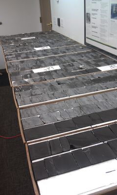
The rock layers formed roughly 360 million years ago when a shallow sea covered this region and organic materials settled on the seabed. These ancient deposits transformed over time into the petroleum now extracted from deep within these buried strata.

Location: Montana

Location: North Dakota

Location: Saskatchewan

Location: Manitoba

GPS coordinates: 48.39290,-102.93990

Latest update: December 13, 2025 16:47

Photos
Around this place
United States of America

91st Missile Wing LGM-30 Minuteman Missile Launch Sites

99.6 km
Fort Buford
United States of America

Fort Buford

90.8 km
Four Bears Bridge
United States of America

Four Bears Bridge

53.9 km
Snowden Bridge
United States of America

Snowden Bridge

96.3 km
Missouri-Yellowstone Confluence Interpretive Center
United States of America

Missouri-Yellowstone Confluence Interpretive Center

90.1 km
Fairview Lift Bridge
United States of America

Fairview Lift Bridge

92 km
Des Lacs National Wildlife Refuge
United States of America

Des Lacs National Wildlife Refuge

79.8 km
Ambrose–Torquay Border Crossing
Canada

Ambrose–Torquay Border Crossing

78.6 km
Crow Flies High State Recreation Area
United States of America

Crow Flies High State Recreation Area

54.2 km
Great Northern Railway Underpass
United States of America

Great Northern Railway Underpass

41.5 km
Alkabo School
United States of America

Alkabo School

87.3 km
United States of America

Lostwood Wilderness

46.1 km
Portal State Bank
United States of America

Portal State Bank

73 km
James Memorial Library
United States of America

James Memorial Library

57.4 km
Renville County Courthouse
United States of America

Renville County Courthouse

113.2 km
Niels Nielsen Fourteen-Side Barn Farm
United States of America

Niels Nielsen Fourteen-Side Barn Farm

48.9 km
Divide County Courthouse
United States of America

Divide County Courthouse

63.7 km
Old U.S. Post Office
United States of America

Old U.S. Post Office

57.7 km
Ray Opera House
United States of America

Ray Opera House

17.6 km
Mountrail County Courthouse
United States of America

Mountrail County Courthouse

41.4 km
Wabek Consolidated School
United States of America

Wabek Consolidated School

86.9 km
Van Hook State Wildlife Management Area
United States of America

Van Hook State Wildlife Management Area

67.5 km
Fort Union Trading Post National Historic Site
United States of America

Fort Union Trading Post National Historic Site

92.7 km
First English Free Lutheran Church (Lostwood)
United States of America

First English Free Lutheran Church (Lostwood)

39.3 km
Paul Broste Rock Museum
United States of America

Paul Broste Rock Museum

76.9 km
Fort Buford State Historic Site
United States of America

Fort Buford State Historic Site

90.7 km
Columbus Theatre
United States of America

Columbus Theatre

58.1 km
River Bend Overlook
United States of America

River Bend Overlook

93.2 km
Show the full map
Reviews

Visited this place? Tap the stars to rate it and share your experience / photos with the community! Try now! You can cancel it anytime.

« Bakken formation - Geological formation in Montana and North Dakota, United States » is provided by Around Us (aroundus.com). Images and texts are derived from Wikimedia project under a Creative Commons license. You are allowed to copy, distribute, and modify copies of this page, under the conditions set by the license, as long as this note is clearly visible.

Discover hidden gems everywhere you go!

From secret cafés to breathtaking viewpoints, skip the crowded tourist spots and find places that match your style. Our app makes it easy with voice search, smart filtering, route optimization, and insider tips from travelers worldwide. Download now for the complete mobile experience.

Around Us App Screenshot

A unique approach to discovering new places

Le Figaro

All the places worth exploring

France Info

A tailor-made excursion in just a few clicks

20 Minutes