Crow Flies High State Recreation Area

Log in to your account

AroundUs is a community-driven map of interesting places, built by curious explorers like you. It grows with every review, story, and photo you share.
Connect to save your favorite spots, contribute locations, and create personalized routes.
By continuing, you accept our Terms and Conditions and our Privacy Policy

Crow Flies High State Recreation Area

Add to collection
Map
Suggest a change
Share

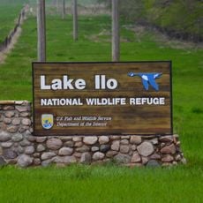
Crow Flies High State Recreation Area, Historic site and recreation area near New Town, North Dakota
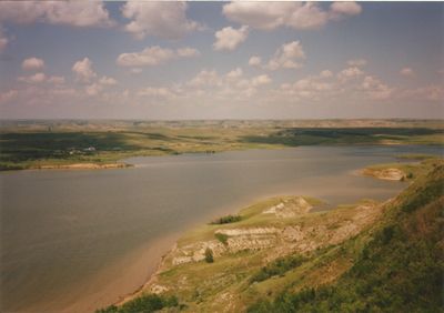
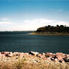
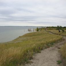
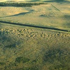
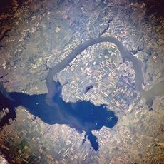
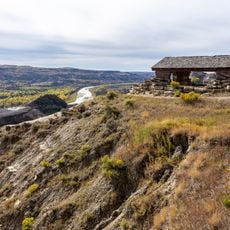
Crow Flies High State Recreation Area spans 247 acres at an elevation of 2,087 feet, offering views of Lake Sakakawea and Four Bears Bridge.

The National Park Service managed this location from 1917 until 1956 when ownership transferred to the North Dakota Parks and Recreation Department.

The name honors Hidatsa Indian chief Crow Flies High, with the site located within the boundaries of Fort Berthold Indian Reservation.

Visitors access the area via Highway 23, with free admission and designated areas for hiking and sightseeing, but no overnight facilities.

During periods of low water in Lake Sakakawea, visitors can observe the remnants of Sanish, a submerged town beneath the reservoir.

Location: North Dakota

GPS coordinates: 47.98250,-102.54600

Latest update: March 9, 2025 23:56

Around this place
Show the full map
Bakken formation
United States of America

Bakken formation

54.2 km
Scandinavian Heritage Park
United States of America

Scandinavian Heritage Park

96.7 km
Maysa Arena
United States of America

Maysa Arena

94.1 km
Four Bears Bridge
United States of America

Four Bears Bridge

1.2 km
Lake Sakakawea State Park
United States of America

Lake Sakakawea State Park

96.5 km
Fort Stevenson State Park
United States of America

Fort Stevenson State Park

94.8 km
Lake Ilo National Wildlife Refuge
United States of America

Lake Ilo National Wildlife Refuge

72.7 km
Great Northern Railway Underpass
United States of America

Great Northern Railway Underpass

39.3 km
Lynch Quarry Site
United States of America

Lynch Quarry Site

70.3 km
Taube Museum of Art
United States of America

Taube Museum of Art

97.3 km
Lostwood Wilderness
United States of America

Lostwood Wilderness

74.6 km
Old Main (Minot State University)
United States of America

Old Main (Minot State University)

97.1 km
James Memorial Library
United States of America

James Memorial Library

82.3 km
Minot Carnegie Library
United States of America

Minot Carnegie Library

97.4 km
Bruce M. Van Sickle Federal Building and U.S. Courthouse
United States of America

Bruce M. Van Sickle Federal Building and U.S. Courthouse

97.2 km
Old U.S. Post Office
United States of America

Old U.S. Post Office

82.3 km
Ray Opera House
United States of America

Ray Opera House

61.2 km
Mountrail County Courthouse
United States of America

Mountrail County Courthouse

39.4 km
Union National Bank and Annex
United States of America

Union National Bank and Annex

97.4 km
Tufveson House
United States of America

Tufveson House

96.9 km
Wabek Consolidated School
United States of America

Wabek Consolidated School

43.8 km
Andrew Carr, Sr., House
United States of America

Andrew Carr, Sr., House

96.8 km
Van Hook State Wildlife Management Area
United States of America

Van Hook State Wildlife Management Area

18.3 km
First English Free Lutheran Church (Lostwood)
United States of America

First English Free Lutheran Church (Lostwood)

55.7 km
Scandinavian Heritage Association
United States of America

Scandinavian Heritage Association

96.8 km
Paul Broste Rock Museum
United States of America

Paul Broste Rock Museum

31 km
River Bend Overlook
United States of America

River Bend Overlook

74.9 km
Cannonball Concretions Pullout
United States of America

Cannonball Concretions Pullout

72.8 km
Show the full map

Reviews

Visited this place? Tap the stars to rate it and share your experience / photos with the community! Try now! You can cancel it anytime.

« Crow Flies High State Recreation Area - Historic site and recreation area near New Town, North Dakota » is provided by Around Us (aroundus.com). Images and texts are derived from Wikimedia project under a Creative Commons license. You are allowed to copy, distribute, and modify copies of this page, under the conditions set by the license, as long as this note is clearly visible.

Discover hidden gems everywhere you go!

From secret cafés to breathtaking viewpoints, skip the crowded tourist spots and find places that match your style. Our app makes it easy with voice search, smart filtering, route optimization, and insider tips from travelers worldwide. Download now for the complete mobile experience.

Around Us App Screenshot

A unique approach to discovering new places

Le Figaro

All the places worth exploring

France Info

A tailor-made excursion in just a few clicks

20 Minutes