Enable Location

We need your location to show you interesting places around you

Discover nearby places

Find interesting locations and hidden gems around you

Precise directions

Get accurate directions and distances to places

Your location is never shared with other users. It's only used when you tap the location button.

Four Bears Bridge

Log in to your account

Start exploring — it's free

Trusted by 61,364 travelers worldwide

Continue with Google
Continue with Apple
or

We will send you a code to connect

By continuing, you accept our Terms and Conditions and our Privacy Policy

Check your inbox

We've sent a pincode in your inbox. Please enter the code below.

Four Bears Bridge

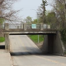
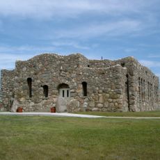
Four Bears Bridge, Road bridge in New Town, United States

Description

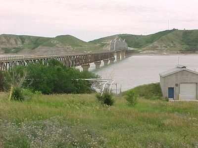
The Four Bears Bridge is a road crossing spanning nearly 2 kilometers (1 mile) across the Missouri River, linking New Town with communities to the south. The structure uses arches between piers and follows the natural contours of the surrounding landscape.

History

Construction of this bridge took place between 2003 and 2005, replacing an earlier structure from 1934 that had to be relocated when the Garrison Dam created a reservoir. The rising water made the old crossing unusable.

Culture

The bridge displays medallions honoring the Mandan, Hidatsa, and Arikara tribes and nineteen of their leaders. These emblems serve as visible recognition of the indigenous peoples whose lands surround the crossing.

Practical

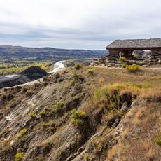
The bridge carries Highway 23 traffic safely between the two communities and accommodates pedestrian walkers. Visitors can use observation points along the crossing to look out over the lake and surrounding terrain.

Did you know?

The arches between the piers are intentionally designed to mirror the shape of nearby hills, creating a subtle connection between the bridge and its surroundings. This thoughtful design allows the crossing to blend naturally with the landscape.

Location
GPS coordinates
47.97970,-102.56200
Latest update
December 12, 2025 09:05

AroundUs brings together thousands of curated places, local tips, and hidden gems, enriched daily by 60,000 contributors worldwide. Discover all places nearby (North Dakota).

Around this place
Bakken formation
Canada

Bakken formation

53.9 km
Scandinavian Heritage Park
United States of America

Scandinavian Heritage Park

97.9 km
Maysa Arena
United States of America

Maysa Arena

95.3 km
Lake Sakakawea State Park
United States of America

Lake Sakakawea State Park

97.3 km
Fort Stevenson State Park
United States of America

Fort Stevenson State Park

95.8 km
Lake Ilo National Wildlife Refuge
United States of America

Lake Ilo National Wildlife Refuge

72.2 km
Crow Flies High State Recreation Area
United States of America

Crow Flies High State Recreation Area

1.2 km
Great Northern Railway Underpass
United States of America

Great Northern Railway Underpass

39.9 km
Lynch Quarry Site
United States of America

Lynch Quarry Site

69.9 km
Taube Museum of Art
United States of America

Taube Museum of Art

98.6 km
United States of America

Lostwood Wilderness

75.1 km
Old Main (Minot State University)
United States of America

Old Main (Minot State University)

98.3 km
James Memorial Library
United States of America

James Memorial Library

81.2 km
Minot Carnegie Library
United States of America

Minot Carnegie Library

98.7 km
Bruce M. Van Sickle Federal Building and U.S. Courthouse
United States of America

Bruce M. Van Sickle Federal Building and U.S. Courthouse

98.5 km
Old U.S. Post Office
United States of America

Old U.S. Post Office

81.3 km
Ray Opera House
United States of America

Ray Opera House

60.6 km
Mountrail County Courthouse
United States of America

Mountrail County Courthouse

40.1 km
Union National Bank and Annex
United States of America

Union National Bank and Annex

98.6 km
Tufveson House
United States of America

Tufveson House

98.1 km
Wabek Consolidated School
United States of America

Wabek Consolidated School

45 km
Andrew Carr, Sr., House
United States of America

Andrew Carr, Sr., House

98.1 km
Van Hook State Wildlife Management Area
United States of America

Van Hook State Wildlife Management Area

19.4 km
First English Free Lutheran Church (Lostwood)
United States of America

First English Free Lutheran Church (Lostwood)

56.2 km
Scandinavian Heritage Association
United States of America

Scandinavian Heritage Association

98 km
Paul Broste Rock Museum
United States of America

Paul Broste Rock Museum

32.1 km
River Bend Overlook
United States of America

River Bend Overlook

73.7 km
Cannonball Concretions Pullout
United States of America

Cannonball Concretions Pullout

71.7 km
Show the full map
« Four Bears Bridge - Road bridge in New Town, United States » is provided by Around Us (aroundus.com). Images and texts are derived from Wikimedia project under a Creative Commons license. You are allowed to copy, distribute, and modify copies of this page, under the conditions set by the license, as long as this note is clearly visible.

Discover hidden gems everywhere you go!

From secret cafés to breathtaking viewpoints, skip the crowded tourist spots and find places that match your style. Our app makes it easy with voice search, smart filtering, route optimization, and insider tips from travelers worldwide. Download now for the complete mobile experience.

Around Us App Screenshot

A unique approach to discovering new places

Le Figaro

All the places worth exploring

France Info

A tailor-made excursion in just a few clicks

20 Minutes

Around Us
Travel Guide & Maps
Download

Send to your phone

QR Code
1

Open the camera app on your mobile.

2

Point at the QR code with your camera. A notification will appear.

3

Tap the notification to open the link.