Enable Location

We need your location to show you interesting places around you

Discover nearby places

Find interesting locations and hidden gems around you

Precise directions

Get accurate directions and distances to places

Your location is never shared with other users. It's only used when you tap the location button.

Log in to your account

Start exploring — it's free

Trusted by 65,307 travelers worldwide

Continue with Google
Continue with Apple
or

We will send you a code to connect

By continuing, you accept our Terms and Conditions and our Privacy Policy

Check your inbox

We've sent a pincode in your inbox. Please enter the code below.

Lake Zahl National Wildlife Refuge
Discussion Reviews Photo
1.2k Popularity

Lake Zahl National Wildlife Refuge, National Wildlife Refuge in Williams County, North Dakota

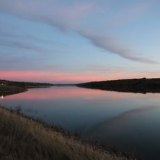
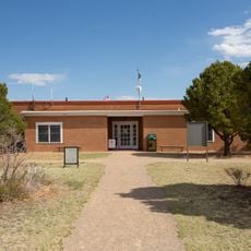
Lake Zahl National Wildlife Refuge is a protected area in Williams County, North Dakota, comprising wetlands and prairie grasslands. The landscape features open water areas and natural grassland expanses that provide habitat for waterfowl and other wildlife.

The refuge was established in 1939 to create breeding grounds for migratory birds in the region. Its creation followed growing recognition of wetlands' importance as wildlife habitat.

The refuge sits within the Prairie Pothole Region, which produces fifty percent of North America's breeding waterfowl population through its network of wetlands.

The refuge is located roughly 50 kilometers north of Williston and accessible via Highway 85. Visitors should be prepared for open terrain and variable weather conditions, so appropriate gear is recommended.

The refuge operates through partnership with local farmers and ranchers who actively contribute to wildlife management. This collaboration demonstrates how private landowners and conservation efforts can work together effectively.

The community of curious travelers

AroundUs brings together thousands of curated places, local tips, and hidden gems, enriched daily by 60,000 contributors worldwide.

Start exploring
Location
Inception
1939
GPS coordinates
48.56440,-103.66200
Latest update
December 14, 2025 18:41
Around this place
Bakken formation
Canada

Bakken formation

56.6 km
Fort Buford
United States of America

Fort Buford

69.1 km
Four Bears Bridge
United States of America

Four Bears Bridge

104.3 km
Snowden Bridge
United States of America

Snowden Bridge

70.6 km
Missouri-Yellowstone Confluence Interpretive Center
United States of America

Missouri-Yellowstone Confluence Interpretive Center

68.9 km
Fairview Lift Bridge
United States of America

Fairview Lift Bridge

74.2 km
Des Lacs National Wildlife Refuge
United States of America

Des Lacs National Wildlife Refuge

119.1 km
Ambrose–Torquay Border Crossing
Canada

Ambrose–Torquay Border Crossing

50.1 km
Crow Flies High State Recreation Area
United States of America

Crow Flies High State Recreation Area

105 km
Trossachs
Canada

Trossachs

126.5 km
Great Northern Railway Underpass
United States of America

Great Northern Railway Underpass

97.8 km
Alkabo School
United States of America

Alkabo School

37.4 km
United States of America

Lostwood Wilderness

89.7 km
Portal State Bank
United States of America

Portal State Bank

94.8 km
Rocky Valley Lutheran Church
United States of America

Rocky Valley Lutheran Church

64 km
Daniels County Courthouse
United States of America

Daniels County Courthouse

131.7 km
James Memorial Library
United States of America

James Memorial Library

46.2 km
Peoples' Congregational Church
United States of America

Peoples' Congregational Church

101.5 km
Niels Nielsen Fourteen-Side Barn Farm
United States of America

Niels Nielsen Fourteen-Side Barn Farm

59.6 km
Divide County Courthouse
United States of America

Divide County Courthouse

47.5 km
Old U.S. Post Office
United States of America

Old U.S. Post Office

46.5 km
Ray Opera House
United States of America

Ray Opera House

44 km
Mountrail County Courthouse
United States of America

Mountrail County Courthouse

97.7 km
Van Hook State Wildlife Management Area
United States of America

Van Hook State Wildlife Management Area

121.1 km
Fort Union Trading Post National Historic Site
United States of America

Fort Union Trading Post National Historic Site

68.9 km
First English Free Lutheran Church (Lostwood)
United States of America

First English Free Lutheran Church (Lostwood)

91.9 km
Fort Buford State Historic Site
United States of America

Fort Buford State Historic Site

68.9 km
Columbus Theatre
United States of America

Columbus Theatre

75 km
Show the full map
Reviews
Share your experience

No review yet

Discussions
Start a discussion...

No discussion yet

« Lake Zahl National Wildlife Refuge - National Wildlife Refuge in Williams County, North Dakota » is provided by Around Us (aroundus.com). Images and texts are derived from Wikimedia project under a Creative Commons license. You are allowed to copy, distribute, and modify copies of this page, under the conditions set by the license, as long as this note is clearly visible.

Discover hidden gems everywhere you go!

From secret cafés to breathtaking viewpoints, skip the crowded tourist spots and find places that match your style. Our app makes it easy with voice search, smart filtering, route optimization, and insider tips from travelers worldwide. Download now for the complete mobile experience.

Around Us App Screenshot

A unique approach to discovering new places

Le Figaro

All the places worth exploring

France Info

A tailor-made excursion in just a few clicks

20 Minutes

Around Us
Travel Guide & Maps
Download

Send to your phone

QR Code
1

Open the camera app on your mobile.

2

Point at the QR code with your camera. A notification will appear.

3

Tap the notification to open the link.