Enable Location

We need your location to show you interesting places around you

Discover nearby places

Find interesting locations and hidden gems around you

Precise directions

Get accurate directions and distances to places

Your location is never shared with other users. It's only used when you tap the location button.

Missouri-Yellowstone Confluence Interpretive Center

Log in to your account

Start exploring — it's free

Trusted by 61,910 travelers worldwide

Continue with Google
Continue with Apple
or

We will send you a code to connect

By continuing, you accept our Terms and Conditions and our Privacy Policy

Check your inbox

We've sent a pincode in your inbox. Please enter the code below.

Missouri-Yellowstone Confluence Interpretive Center

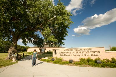
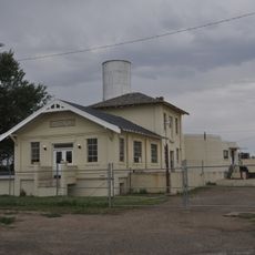
Missouri-Yellowstone Confluence Interpretive Center, History museum at Missouri-Yellowstone rivers confluence near Williston, United States.

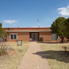
The Missouri-Yellowstone Confluence Interpretive Center is a history museum located where two major American rivers meet near Williston. Its approximately 2,000-square-foot exhibition space presents displays about regional transportation development and the area's natural resources.

The center documents the 1805 Lewis and Clark expedition, which traveled through this area and mapped the confluence of two major rivers. This journey marked a crucial milestone in exploring North American waterways.

The rotunda displays three large murals that incorporate journal entries and paintings by Colonel Philippe Régis de Trobriand from the 1860s frontier period. These artistic works convey impressions of life in the distant regions of that era.

The best time to visit is during the warmer months when the center operates daily with extended hours. Winter visits are possible but with reduced opening times, so plan ahead if traveling during that season.

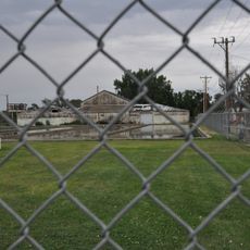
A distinctive feature is the visibility of the exact point where the Missouri and Yellowstone Rivers meet from the center. Visitors can observe this natural phenomenon directly and watch where the two rivers flow together.

The community of curious travelers

AroundUs brings together thousands of curated places, local tips, and hidden gems, enriched daily by 60,000 contributors worldwide.

Start exploring
Location
Address
15349 39th Ln NW, Williston, ND 58801
GPS coordinates
47.98500,-103.98900
Latest update
December 14, 2025 11:24
Around this place
Bakken formation
Canada

Bakken formation

90.1 km
Elkhorn Ranch
United States of America

Elkhorn Ranch

88.1 km
Fort Buford
United States of America

Fort Buford

908 m
Four Bears Bridge
United States of America

Four Bears Bridge

106.3 km
Snowden Bridge
United States of America

Snowden Bridge

8.1 km
Fairview Lift Bridge
United States of America

Fairview Lift Bridge

6.5 km
Crow Flies High State Recreation Area
United States of America

Crow Flies High State Recreation Area

107.5 km
Alkabo School
United States of America

Alkabo School

98.4 km
St. Peter's Catholic Church
United States of America

St. Peter's Catholic Church

112.1 km
Rocky Valley Lutheran Church
United States of America

Rocky Valley Lutheran Church

104.1 km
Merrill Avenue Historic District
United States of America

Merrill Avenue Historic District

112 km
Charles Krug House
United States of America

Charles Krug House

112.1 km
Sacred Heart Church
United States of America

Sacred Heart Church

111.8 km
James Memorial Library
United States of America

James Memorial Library

32.8 km
Peoples' Congregational Church
United States of America

Peoples' Congregational Church

32.7 km
Bell Street Bridge
United States of America

Bell Street Bridge

112.2 km
Wibaux Commercial Historic District
United States of America

Wibaux Commercial Historic District

112.2 km
Old U.S. Post Office
United States of America

Old U.S. Post Office

32.5 km
Ray Opera House
United States of America

Ray Opera House

73 km
Glendive City Water Filtration Plant
United States of America

Glendive City Water Filtration Plant

112.1 km
Northern Pacific Railroad Settling Tanks
United States of America

Northern Pacific Railroad Settling Tanks

112 km
Glendive Dinosaur & Fossil Museum
United States of America

Glendive Dinosaur & Fossil Museum

109.3 km
Blackstock Residence
United States of America

Blackstock Residence

112 km
Fort Union Trading Post National Historic Site
United States of America

Fort Union Trading Post National Historic Site

4.2 km
Fort Buford State Historic Site
United States of America

Fort Buford State Historic Site

900 m
Elkhorn Ranch State Historic Site
United States of America

Elkhorn Ranch State Historic Site

86 km
River Bend Overlook
United States of America

River Bend Overlook

62 km
Cannonball Concretions Pullout
United States of America

Cannonball Concretions Pullout

65.4 km
Show the full map
« Missouri-Yellowstone Confluence Interpretive Center - History museum at Missouri-Yellowstone rivers confluence near Williston, United States » is provided by Around Us (aroundus.com). Images and texts are derived from Wikimedia project under a Creative Commons license. You are allowed to copy, distribute, and modify copies of this page, under the conditions set by the license, as long as this note is clearly visible.

Discover hidden gems everywhere you go!

From secret cafés to breathtaking viewpoints, skip the crowded tourist spots and find places that match your style. Our app makes it easy with voice search, smart filtering, route optimization, and insider tips from travelers worldwide. Download now for the complete mobile experience.

Around Us App Screenshot

A unique approach to discovering new places

Le Figaro

All the places worth exploring

France Info

A tailor-made excursion in just a few clicks

20 Minutes

Around Us
Travel Guide & Maps
Download

Send to your phone

QR Code
1

Open the camera app on your mobile.

2

Point at the QR code with your camera. A notification will appear.

3

Tap the notification to open the link.