Lansdale Silk Hosiery Compy-Interstate Hosiery Mills, Inc.

Log in to your account

AroundUs is a community-driven map of interesting places, built by curious explorers like you. It grows with every review, story, and photo you share.
Connect to save your favorite spots, contribute locations, and create personalized routes.
Continue with Google
Continue with Apple
Continue with X
Continue with Facebook
Continue with email
By continuing, you accept our Terms and Conditions and our Privacy Policy
Create an account

Lansdale Silk Hosiery Compy-Interstate Hosiery Mills, Inc.

Add to collection
Map
Suggest a change
Share

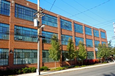
Lansdale Silk Hosiery Compy-Interstate Hosiery Mills, Inc., Historic textile mill in Lansdale, United States.

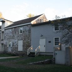
The Lansdale Silk Hosiery Compy-Interstate Hosiery Mills is an industrial complex with multiple connected buildings of varying heights and construction materials. The ensemble features distinctive brick and stone structures that reflect different periods of expansion and development.

The complex was built starting in the 1920s and expanded through the following decades to meet growing demand for women's hosiery products. Successive construction phases reflected the mill's growing success and importance to the regional economy.

The mill was a major employer that shaped daily life for generations of local workers and their families. The site reflects how factories defined community identity and economic well-being in industrial America.

The mill complex is situated in downtown Lansdale and visible from the street, with its industrial architecture clearly marking the area. Visitors can walk around the exterior to appreciate the scale and arrangement of the different buildings that made up this production facility.

The site was added to the National Register of Historic Places in 2004, officially recognizing its architectural and economic importance to the region. This designation helps preserve the complex as a tangible record of how manufacturing shaped the area's development.

Location: Pennsylvania

Inception: 1922

GPS coordinates: 40.23920,-75.28170

Latest update: December 14, 2025 17:40

Photos
Around this place
Lindenwold Castle
United States of America

Lindenwold Castle

11.5 km
Graeme Park
United States of America

Graeme Park

11.5 km
Evansburg State Park
United States of America

Evansburg State Park

8.2 km
Edward Morgan Log House
United States of America

Edward Morgan Log House

2.7 km
Power Line Trail
United States of America

Power Line Trail

11.6 km
Peter Wentz Homestead
United States of America

Peter Wentz Homestead

6.3 km
Dawesfield
United States of America

Dawesfield

10 km
Old Norriton Presbyterian Church
United States of America

Old Norriton Presbyterian Church

11.9 km
Knapp Farm
United States of America

Knapp Farm

3.1 km
Upper Dublin Friends Meeting House
United States of America

Upper Dublin Friends Meeting House

11.8 km
Gwynedd Hall
United States of America

Gwynedd Hall

5.1 km
Pine Valley Covered Bridge
United States of America

Pine Valley Covered Bridge

10.9 km
Warren Z. Cole House
United States of America

Warren Z. Cole House

9.3 km
Henry Schmieder Arboretum
United States of America

Henry Schmieder Arboretum

12.4 km
Klein Meetinghouse
United States of America

Klein Meetinghouse

9.9 km
Isaac Kulp Farm
United States of America

Isaac Kulp Farm

3.6 km
Bridge in Franconia Township
United States of America

Bridge in Franconia Township

7.3 km
Bridge in Hatfield Township
United States of America

Bridge in Hatfield Township

5 km
Anthony Morris House
United States of America

Anthony Morris House

9.4 km
Chalfont Historic District
United States of America

Chalfont Historic District

8.3 km
Dielman Kolb Homestead
United States of America

Dielman Kolb Homestead

10.3 km
Jacob Kastner Loghouse
United States of America

Jacob Kastner Loghouse

8.8 km
Morgan James Homestead
United States of America

Morgan James Homestead

10.1 km
Knipe–Johnson Farm
United States of America

Knipe–Johnson Farm

3.6 km
Horsham–Montgomery Bridge
United States of America

Horsham–Montgomery Bridge

7.6 km
Knipe-Moore-Rupp Farm
United States of America

Knipe-Moore-Rupp Farm

2.9 km
Keefe-Mumbower Mill
United States of America

Keefe-Mumbower Mill

5.8 km
Oak Park Historic District
United States of America

Oak Park Historic District

2.1 km
Show the full map
Reviews

Visited this place? Tap the stars to rate it and share your experience / photos with the community! Try now! You can cancel it anytime.

« Lansdale Silk Hosiery Compy-Interstate Hosiery Mills, Inc. - Historic textile mill in Lansdale, United States » is provided by Around Us (aroundus.com). Images and texts are derived from Wikimedia project under a Creative Commons license. You are allowed to copy, distribute, and modify copies of this page, under the conditions set by the license, as long as this note is clearly visible.

Discover hidden gems everywhere you go!

From secret cafés to breathtaking viewpoints, skip the crowded tourist spots and find places that match your style. Our app makes it easy with voice search, smart filtering, route optimization, and insider tips from travelers worldwide. Download now for the complete mobile experience.

Around Us App Screenshot

A unique approach to discovering new places

Le Figaro

All the places worth exploring

France Info

A tailor-made excursion in just a few clicks

20 Minutes