Enable Location

We need your location to show you interesting places around you

Discover nearby places

Find interesting locations and hidden gems around you

Precise directions

Get accurate directions and distances to places

Your location is never shared with other users. It's only used when you tap the location button.

Lehigh Valley Railroad Bridge

Log in to your account

Start exploring — it's free

Trusted by 61,993 travelers worldwide

Continue with Google
Continue with Apple
or

We will send you a code to connect

By continuing, you accept our Terms and Conditions and our Privacy Policy

Check your inbox

We've sent a pincode in your inbox. Please enter the code below.

Lehigh Valley Railroad Bridge

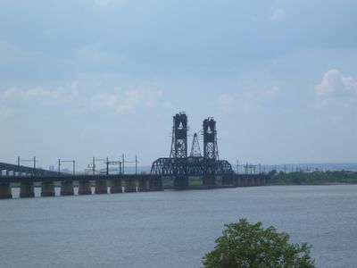
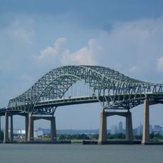
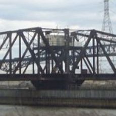
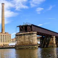
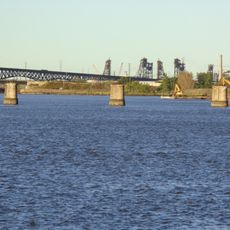
Lehigh Valley Railroad Bridge, Railway vertical lift bridge in Newark, United States.

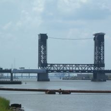
The Lehigh Valley Railroad Bridge is a steel vertical-lift bridge that spans Newark Bay and connects two large freight rail yards on opposite sides. Its mechanical lifting system allows the span to rise when ships need to pass beneath, while the structure itself sits on massive stone and concrete supports.

This bridge was built between 1928 and 1930 to replace an earlier wooden structure that was destroyed in 1913. The original wooden bridge was rebuilt in just twelve days after that fire, reflecting how critical this crossing was for commerce.

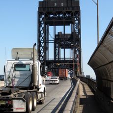
The bridge connects two significant rail freight yards and serves as a visible symbol of how railroads remain important for moving goods across this region. Passing trains are part of the daily rhythm for workers and residents in nearby areas.

The bridge itself is not open to public walking, as this is an active private rail facility with restricted access. Views are best from nearby shoreline areas or by boat from the bay, where you can see the structure and watch trains cross.

The lift mechanism rarely operates today because few modern ships are tall enough to require the bridge to raise. Yet this mechanical system remains intact and functional, a holdover from an earlier era of busy harbor traffic.

The community of curious travelers

AroundUs brings together thousands of curated places, local tips, and hidden gems, enriched daily by 60,000 contributors worldwide.

Start exploring
Inception
1930
Official opening
1930
GPS coordinates
40.69905,-74.11957
Latest update
December 12, 2025 09:03
Around this place
Sports Illustrated Stadium
United States of America

Sports Illustrated Stadium

4.9 km
Pulaski Skyway
United States of America

Pulaski Skyway

4.9 km
Roosevelt Stadium
United States of America

Roosevelt Stadium

1.5 km
Newark Bay Bridge
United States of America

Newark Bay Bridge

429 m
Lincoln Park
United States of America

Lincoln Park

4.3 km
Port Jersey
United States of America

Port Jersey

5 km
Newark Riverfront Park
United States of America

Newark Riverfront Park

4.5 km
United States of America

Newark water crisis

4.9 km
Jackson Street Bridge
United States of America

Jackson Street Bridge

4.9 km
Lincoln Highway Hackensack River Bridge
United States of America

Lincoln Highway Hackensack River Bridge

3.6 km
Saint Patrick's Roman Catholic Church
United States of America

Saint Patrick's Roman Catholic Church

4.3 km
Point-No-Point Bridge
United States of America

Point-No-Point Bridge

4.7 km
Lincoln Highway Passaic River Bridge
United States of America

Lincoln Highway Passaic River Bridge

3.7 km
Afro-American Historical and Cultural Society Museum
United States of America

Afro-American Historical and Cultural Society Museum

2.4 km
Jersey City YMCA
United States of America

Jersey City YMCA

4.7 km
United States of America

Lincoln the Mystic

4.5 km
Riverbank Park
United States of America

Riverbank Park

4.6 km
PD Draw
United States of America

PD Draw

2.7 km
St. Stephan's Church
United States of America

St. Stephan's Church

4.4 km
Fairmount Apartments
United States of America

Fairmount Apartments

4.8 km
St. Joseph Cathedral
United States of America

St. Joseph Cathedral

3.9 km
Bayonne Public Library
United States of America

Bayonne Public Library

3.1 km
Hackensack Drawbridge
United States of America

Hackensack Drawbridge

2.6 km
First Reformed Dutch Church of Bergen Neck
United States of America

First Reformed Dutch Church of Bergen Neck

2.9 km
Bayonne Truck House No. 1
United States of America

Bayonne Truck House No. 1

2.4 km
Statue of Mary McLeod Bethune
United States of America

Statue of Mary McLeod Bethune

2.8 km
Newark Metropolitan Airport Buildings
United States of America

Newark Metropolitan Airport Buildings

3.7 km
Essex County Correctional Facility
United States of America

Essex County Correctional Facility

2.5 km
Show the full map
« Lehigh Valley Railroad Bridge - Railway vertical lift bridge in Newark, United States » is provided by Around Us (aroundus.com). Images and texts are derived from Wikimedia project under a Creative Commons license. You are allowed to copy, distribute, and modify copies of this page, under the conditions set by the license, as long as this note is clearly visible.

Discover hidden gems everywhere you go!

From secret cafés to breathtaking viewpoints, skip the crowded tourist spots and find places that match your style. Our app makes it easy with voice search, smart filtering, route optimization, and insider tips from travelers worldwide. Download now for the complete mobile experience.

Around Us App Screenshot

A unique approach to discovering new places

Le Figaro

All the places worth exploring

France Info

A tailor-made excursion in just a few clicks

20 Minutes

Around Us
Travel Guide & Maps
Download

Send to your phone

QR Code
1

Open the camera app on your mobile.

2

Point at the QR code with your camera. A notification will appear.

3

Tap the notification to open the link.